
7 Incredible Walks on the Pembrokeshire Coastal Path

Blue Lagoon
Pembrokeshire National Park is a walkers delight.
Surrounded by the sea on three sides, it has 186-miles of beautiful unspoiled coastline lined with arguably some of the finest coastal path in the entire world.
Hidden amongst the national parks encaptivating coastline are some of the most incredible beaches in the UK, alongside costal scenery which will leave you lost for words.
Unfortunately, not everyone has the time, nor stamina to walk all 186 miles of the costal path. Fortunately, I cycled the majority of the Pembrokeshire coastal path back in 2019, so to save you the deliberation of trying to narrow the choices down I have picked out 7 of my favourite sections.
If I was going to select two favourites from the list they would be Porthgain to Blue Lagoon and Bosherton lily ponds to Barafundle.
I’m not going to claim these are the best walks in Pembrokeshire as everyone has subjective views. I will claim that these seven walks encompass some of the finest coastal views and visit some of most spectacular coastal features that the national park has to offer. I can guarantee that no matter which walk you select you wont be disappointed, and if by some chance you are, you need to have your eye sight checked.
As the Pembrokeshire costal path is unbroken, all of these walks can be extended by continuing along the coastline. In fact you could even combine two or more of these walks create one terrific day out. So fill up a backpack, slap on the sun cream, and don’t forget to bring a towel.
I hope you find the information on these pages useful. If you have any questions, comments or issues with the post please feel free to let me know in the comments below.
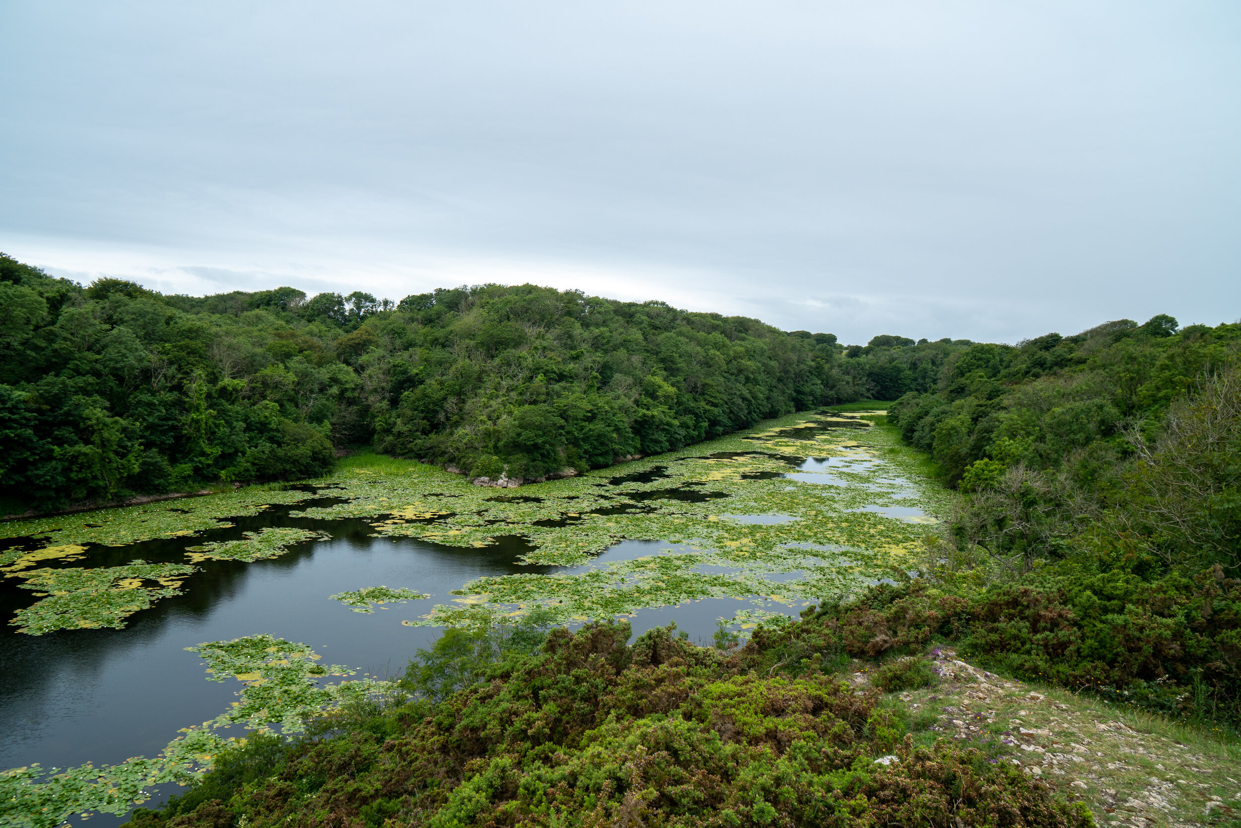
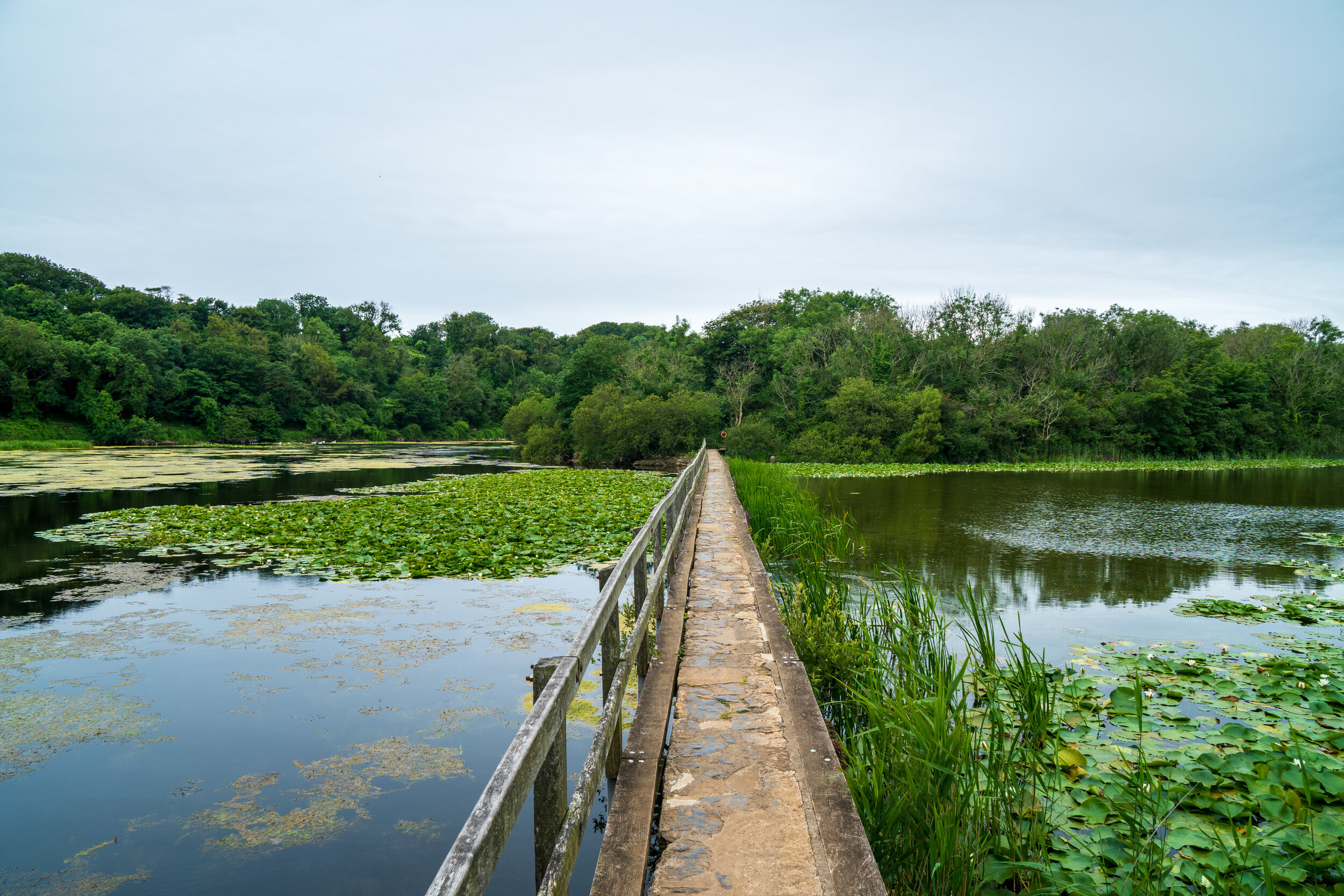
Bosherston Lily ponds, Broadhaven South, and Barafundle Bay
One of my favourite walks on the peninsula, its one which encompasses two of Pembrokeshire finest beautiful golden sanded beaches, dramatic coastal cliffs and enchanting walk through the magical Bosherston lily ponds.


Barafundle bay with Broadhaven South in the background
The Route
A large national trust car park can be found in Bosherton village, where there are also toilets, a country pub, and a small café. Alternatively you can begin this walk from Stackpole Quay. This walk can be complete in either a clockwise or Anti clockwise direction.
From the car park take the one-mile walk through the lovely Bosherton Lily ponds. The man-made lakes are famous for their spectacular display of waterlilies and their resident otters and make for a tranquil way to access the beach. Once at Broadhaven south head eastwards and follow the dramatic limestone cliffs towards Barafundle bay. You’ll dip in an out of the headlands as the cliffs plunge almost vertically into the sea below .
After around 2km you should reach Barafundle bay. With its golden sands and crystal clear waters backed by sand dunes and pine trees, its easy to see why Barafundle is constantly voted as one of the best beaches not only in Britain but also Europe.
From Barafundle continue eastwards to Stackpole Quay, a quaint little harbour tucked away between two headlands. Here you’ll find another national trust car park with a café and toilets. From Stackpole Quay cut through through Stackpole park until you reach eight arch bridge. Cross the bridge and follow the shores of the lily pond back to the car park.


Porthgain to Blue Lagoon
A real cracker of an out and back walk on Pembrokeshire north Coast, which was rated by The Guardian as one of the Top 10 UK walks back in 2010. The relatively flat route follows the dramatic coastal cliffs as its passes hidden beaches on the way to the magnificent Blue Lagoon.


Blue Lagoon,
The hike can be started at either Porthgain harbour or from the shoreline of Abereiddi beach. My recommendation would be to park at Porthgain (SA62 5BN), as you can have a swim at the mid point of your hike in Blue Lagoon and celebrate with a pint alongside fish and chips at The Sloop.
The Route
The route is very easy to follow, from Porthgain harbour climb up past the old brick works onto the cliff path, continue westwards passing the remains of another granite quarry as the path hugs the cliff top.
You will eventually pass by beautiful Traeth Llyfn. Translated from Welsh to ‘Smooth beach’ this is a real hidden gem on the northern coast of Pembrokeshire. The sandy beach is backed by towering cliffs which can be accessed by a steep metal staircase cut into the cliff face. From here its only a short walk onto Blue Lagoon.
Pembrokeshire's Blue lagoon is abandoned slate quarry, filled with turquoise water on the north coast of the coastal path. Shut down in 1910, the seaward wall of the quarry was blasted open by fisherman in order to flood the mine and provide refuge for their boats.
The spectacular nature and location of Blue lagoon has resulted in it being chosen as a stop on the Red Bull cliff diving series in 2012, 2013 & 2016. The events saw the world's best divers leap from a man-made platform, suspended 27 metres above the quarry.
The diving board has since been taken down but if you are feeling brave enough you can leap from the several platforms, ranging from 2 to 10m, on the far side of the quarry. Don’t worry about hitting the bottom, the water is over 25m deep.
There are also public toilets located in Aberreiddi car park.
From Blue Lagoon simply retrace your steps back along the coastal path to Porthgain and celebrate with a well earned pint alongside some fish an chips.

Traeth Llyfn


Porthgain Harbour

Church Door Cove to Manorbier
A very scenic and varied walk which is rich in history and passes some of the geological wonders of the Pembrokeshire coastline.


Shrinkle Haven (Centre) and Church door cove (right)
The Route
Free parking is available either at Manorbier YHA, postcode SA70 7TT, or 500m further along the road, situated on the cliff top adjacent to the coastal path. Alternatively you can begin this walk from Manorbier.
The first stop is the magnificent Church door cove, aceee to the beach is via a short walk down the steep concrete and metal steps (140 in total) which drop down onto the bay.
This is one of Pembrokeshire many geological wonders scattered across it’s rugged coastline. The cove is an amphitheatre-shaped bowl with a magnificent door shaped arch which has been cut into the towering cliffs by the forces of the ocean. At mid to high tide the beach becomes cut off and consists of mainly large boulders, but as the tide drops away a beautiful, sheltered stretch of sand is revealed.
Next door to Church Cove are the golden sands of Shrinkle Haven beach. Unfortunately the steps leading down to the beach have been fenced off. However, the bay is accessible at low tide via Church door cove by either walking around the thin limestone headland or scrambling through a narrow and slippery cave. Be extremely careful if undertaking this trip as this beach will quickly get cut off, and you’ll either have to swim back around or wait 8-10 hours for the tide to retreat.
From Shrinkle Haven follow the coastal path westwards towards Manorbier Beach. On route you will pass the Neolithic burial chamber known as King’s Quoit which was built over 11,500 years ago.
Continue to follow the coastal path until you drop back down onto the shore of Manorbier. This beach is popular with surfers and is overlooked by a 11th century Norman castle. From the shoreline pass the castle and up through the quaint seaside village before circling back around re-join the costal path.
You can extend this walk by either encompassing the Lydstep headland or carrying along the coastline past Manorbier to Freshwater East.

Church door cove
Marloes Peninsula
Explore a beautiful heathland peninsula and stop by the majestical Marloes Sands, another hidden gem of a beach nestled on the very western edge of Pembrokeshire, offering an abundance of wildlife alongside incredible views of the surrounding coastline.


The Route
Parking is available at Marloes Sands car park, near the Runwayskiln cafe, for £5 a day. From here you can access the beach is via half a mile walk along a well-maintained path.
Again you can walk this circular route in a clockwise or anti clockwise fashion. I would recommend walking it in an anti clockwise fashion as you can finish your walk at the highlight of the walk, Marloes Sands.
On route you’ll walk around Wooltack point which will give you terrific views over towards Skomer Island, a world renowned wildlife paradise which is famous for its puffins. You also walk along a spectacular cliff top coastal path which offers the possibility of spotting a wide range of wildlife from grey seals to dolphins.
The highlight of the walk however has to be Marloes Sands. This one mile beach is backed by jagged sandstone cliffs and is divided into into smaller, more secluded bays by the dramatic rock formations which protrude from its golden shores.
Popular with surfers, on Wednesdays and Saturdays in September and October the National Trust arrange guided walks with a ranger to see the seal pups. The beach has also featured in the Hollywood film Snow White and the Huntsman and at low tide, you can see the remains of a wrecked ship sticking out of the sand.
If you’re planning on spending time on its shoreline check out the tide times to make sure you’ve plenty of beach to play on and that you don’t get cut off by the incoming tide.


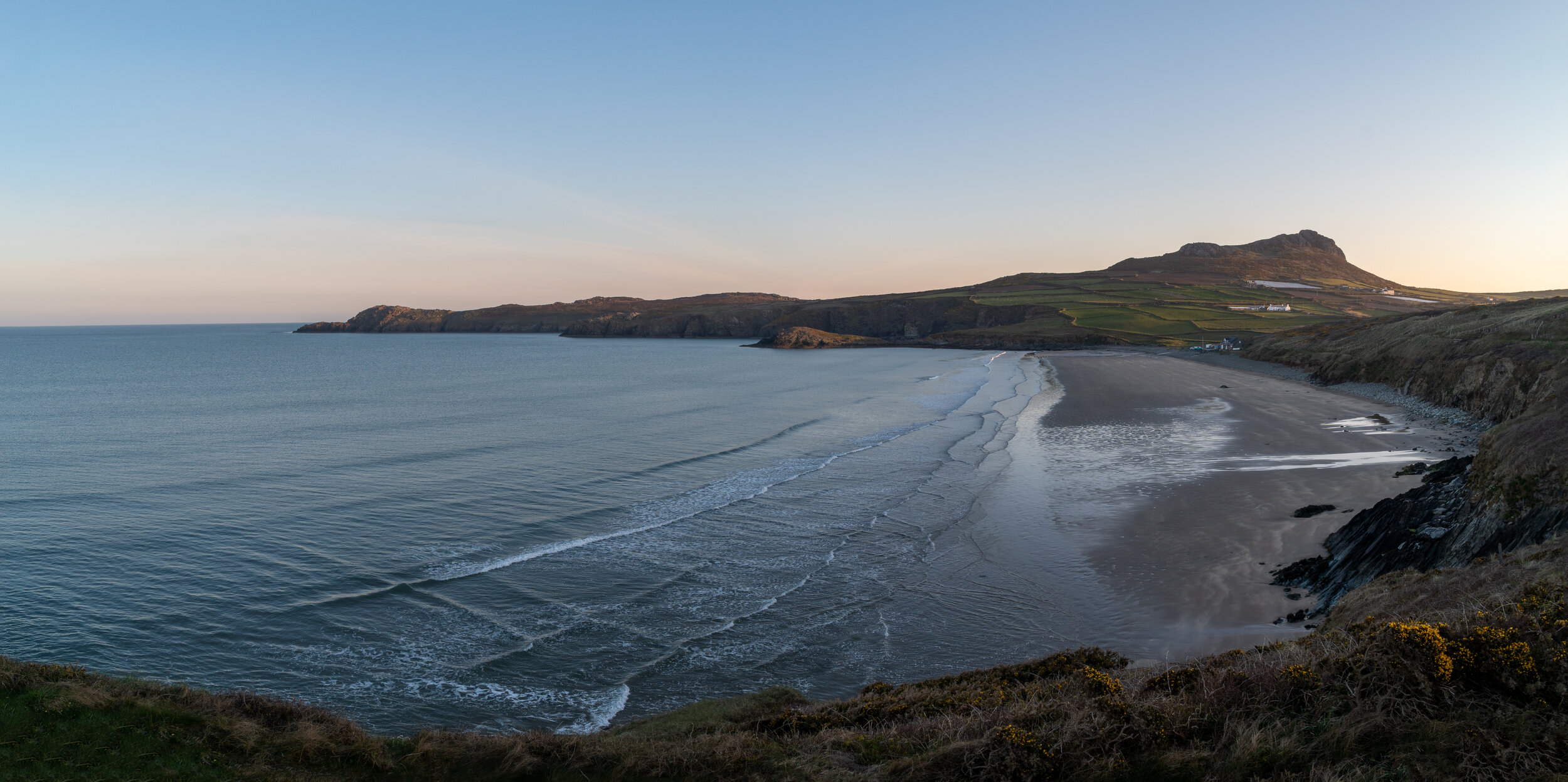
St Davids Head
A golden sanded beach alongside panoramic coastal views from one of the highest points in Pembrokeshire, what more could you ask for?


The view from Carn llidi
The route
Parking is available in Whitesands Car park, (SA62 6PS) for £5 a day. There is only space for 60 vehicles which tends to fill up quickly in the busy summer months. If no spaces are available you can catch the Celtic Coaster shuttle bus from the Oriel Y Parc in St Davids during the summer.
Again I would recommend tackling this walk in an anti-clockwise direction, tackling the craggy peak of Carn Llidi first. The route to the summit isn’t difficult and is well signposted. From Whitesands Bay car park head back up the road and bear left, following the path which rises gently through Porthmawr Farm and up to the small summit.

The view from Carn llidi looking towards Ramsey Island

Looking North east up the northern Pembrokeshire Coast
The 181m hill is rich in history with two burial chambers located on the southwest slopes alongside an old WWII radar station on its summit. You will also be treated to terrific views westwards towards Ramsey Island and northwards towards Strumble Head; on clear evenings you can also get a glimpse of the Wicklow Mountains in Ireland.
From the summit drop back down then loop around the summit to re-join the northern section of the Pembrokeshire costal path.
Pass around St Davids Head, then the sheltered Porthmelgan Beach following the path south back south towards the award-winning Whitesands beach.
Whitesands is extremely popular with families due to its easy access and a wide range of facilities including lifeguards, toilets and a cafe. However, when the swell picks up the beach is renowned for being one of the best surfing spots on the Pembrokeshire coast with people of all ages and abilities flocking here to catch a few waves.

Green Bridge of Wales to St Govan’s Chapel
A magnificent 12km out and back costal walk which skirts around one of the most dramatic sections of the Pembrokeshire costal path whilst passing by several incredible coastal features. Picture the Jurassic coast but with with far less people.


The Route
This route can be started at either the Green Bridge of Wales or St Govan’s Chapel (postcode SA71 5DR). Both car parks are free and are situated less than 100m from the costal path.
If you start at the green bridge of Wales, you have to (legally) drive 2.5km through a MOD military firing range. Unfortunately, as I have found out on two occasions, this road can be closed off during certain times for training exercises. St Govans Chapel is also located on the edge of the firing range and the cliff path can also be closed off in certain circumstances. This will be clearly indicated as there is a barrier and manned booth which will have a red flashing light on the top if the section of the coastal path is closed.
To avoid a wasted trip, you can check that the road through the firing range is open to the public by calling the Pembroke Visitor Centre (+44 01437 776499) or Castlemartin Firing Range (+44 01646 662367).
The route is very flat and follows a well maintained footpath which hugs the steep cliffs which plunge directly into the coast. On route you will pass such costal wonders as the Green Bridge of Wales, Elgug Stacks, the Cauldron and Huntsman’s leap.
The walk will take a lot longer than you expect as you will want to explore and photograph every small headland and cove. Also keep an eye out for seals who often linger on the rocks below.

The Green Bridge of Wales, Like Durdle door but far less people.


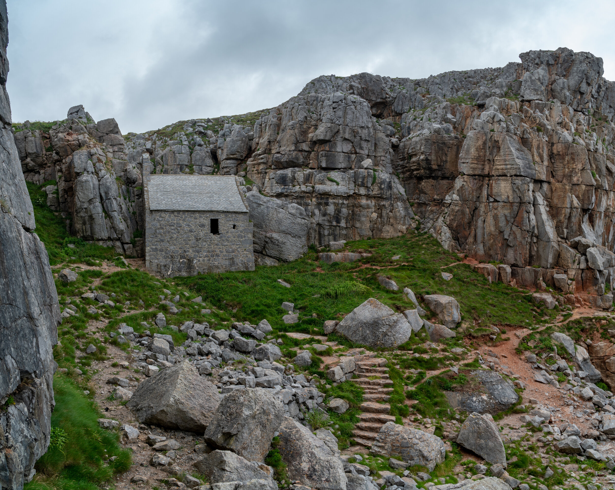
The end point of the hike is St Govan’s Chapel, a tiny stone building carved into the limestone cliffs of the Pembrokeshire Coast. Dating back to 13th Century the chapel was built to honour the hermit St Govan who lived here alone here during the 6th century.
The history of St. Govan is shrouded in mystery. He was believed to fleeing from some pesky Irish pirates when the cliffside allegedly morphed into a secret cave for him to hide in. After successfully evading his captors, Govan chose to set up a monastic hermitage in the cove and remained there for the rest of his life.
However I prefer to believe that he was forced to self isolate there after the 6th century Welsh Coronavirus outbreak started and Mark Drakeford imposed strict restrictions,
The chapel is reached by descending 52 stone steps, polished smooth by the feet of generations of visitors. After passing through the wonderfully atmospheric chapel you are able to head down and marvel at the structure from the rocks below.
To return to the starting point simply retrace your steps back along the coastal path.
For those short on time or energy you can an drive to both the Green Bridge / Elgug stacks and St Govan’s chapel and visit them separately. Both can be reached within 5 minutes of their retrospective car parks.

Strumble Head
Another magnificent circular coastal walk on the North Pembrokeshire coastline. This route passes over the the Garn Fawr iron age hill fort and stops by the impressive Strumble head lighthouse.


Strumble lighthouse
The Route
Free parking is available to the east of the Garn Fawr Hill fort in a small car park (nearest postcode is SA64 0JJ).
From here the route can be tackled in a clockwise or anti-clockwise direction, Clockwise will see you explore the Iron age hill fort and trig point at Garn Fawr first which offers panoramic view back over the northern Pembrokeshire peninsula and up the Ceredigion coastline.
From here the path drops steeply down to the coastal path where it then follows a mixture of footpaths and bridleways as well as some quiet roads. You will also need to negotiate several gates, stiles and some stepping stones over a ford. Take care with children and dogs as the sections of the path run alongside some steep cliffs.
If you didn’t want to tackle the whole route, I would definitely make the gentle 5 minute walk to the summit of Garn Fawr from the free car park to the east of its summit. Once you've taken in the views you can then make the short drive down to the lighthouse car park which is situated right in the costal cliffs it protect ships from.

Looking south-east towards St Davids head from Garn Fawr

Strumble head from Garn Fawr
I hope you found this blog post useful, If you did (or didn’t) let me know in the comments below.
If you did find it helpful, I’d appreciate you giving it a share or giving me a follow on social media, every bit of support goes a long way.
You can find more Welsh hiking inspiration in the following blogs
For more travel, & photography inspiration around Wales check out my in-depth guides to each of my favourite regions below.
