
Whiteford Lighthouse and nature reserve walk guide

A delightful low level walk on the Northwest tip of the Gower Peninsula, which takes in a beautiful nature reserve a sweeping beach alongside an iconic lighthouse.
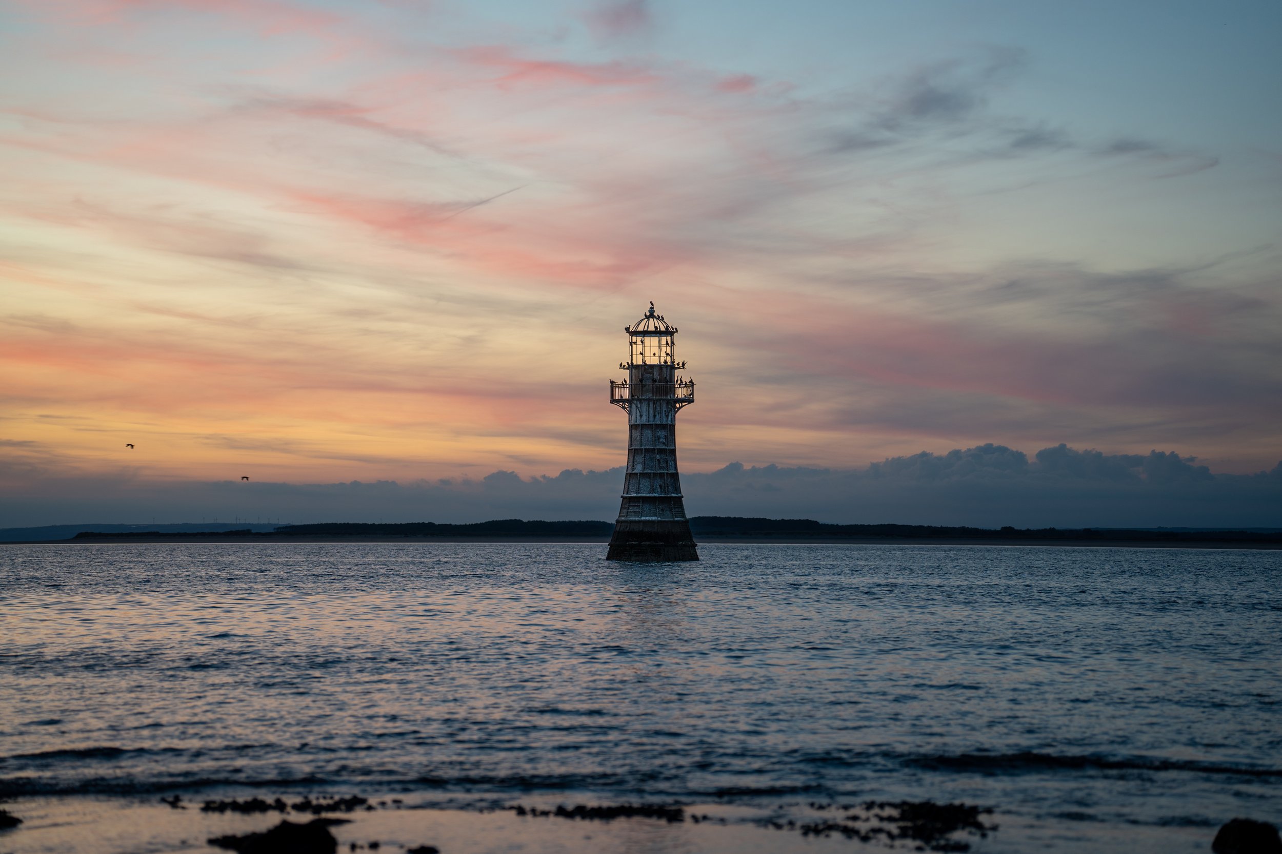
Alongside being a haven for wildlife, including wild horses, at low tide you will be able to access Whiteford lighthouse. The 13m decommissioned lighthouse was built in 1865 and is the only wave-swept cast-iron lighthouse left in Britain.
This walk is mostly level and is a great choice for families. Save this one for a good day and you wont regret it.
Walk Details
Difficulty: Easy / Moderate
Type: Loop
Distance: 8.5km
Ascent: 80m
Surface: Mostly sand and hard coastal path
Duration: 2.5-4 hours
Things to note before departing
Check the tide times, and aim to arrive at the Lighthouse before low tide.
Because the base of the lighthouse is situated half a mile into the Loughor estuary, it is not always accessible, even at low tide.
Trust me I have found out the hard way when i tried to photograph the milky way here and ended up having to wade waist deep into the estuary in my pants at midnight.
You want to aim to head down for low tide on a spring tide (when the the tides are at their biggest). This way you will be guaranteed to be able to reach the base of the lighthouse
Check the tide times available here and aim to get down there around an hour before low tide. The walk to the lighthouse will take at least an hour so factor this into your hike before your start.
Finally as you have to cross an unstable causeway, I’d recommend wearing some suitable walking shoes or stable trainers which you don’t mind getting a little wet and sandy. Again i have found out the hard way by trashing a pair of vans.

a Brief history of Whiteford Lighthouse
The current lighthouse was completed in 1865 to a design by John Bowen, replacing an earlier wooden-pile beacon from 1854. It was commissioned by the Llanelli Harbour and Burry Navigation Commissioners to mark the shifting shoals of Whiteford Point.
Its shell comprises 105 tapered cast-iron plates bolted together, rising from a foundation of 88 timber piles driven into glacial moraine. It was automated in 1919 and finally deactivated in 1926 (with a brief relighting in the 1980s), the tower now stands as both a Grade II* listed building and a Scheduled Ancient Monument under the care of Carmarthenshire County Council.
Where is Whiteford lighthouse located?
Whiteford Lighthouse stands in the the Loughor Estuary on the north-west coast of the Gower Peninsula in South Wales.
Visible from both the Gower shore, Burry Port, and Llanelli, It is located around half a mile offshore from Whiteford Point and marks the shifting shoals at the estuary’s mouth.
It can be accessed on foot at low tide from the village of Llanmadoc (post code SA3 1DB)

Where to park for Whiteford Lighthouse
Parking is available in a farmers field between the villages of Cwm Ivy and Llanmaddoc (SA3 1DE). Parking is free but there is an honesty box so please donate where you can.
To reach the car park drive through the village until you reach the church of St Madoc, which sits at a fork in the road. Take a right down the hill and the car park will be in a field on your next right.
If the car park is closed your alternative option is to find appropriate roadside parking in the village of Llanmaddoc. Please be considerate of residents if doing so.
The route
From car park take a right and follow the road down to Cwm Ivy coffee shop. Stay left and pass alongside the houses, through the wooden kissing and metal swing gates down the hill.
Once at the bottom of the hill take a right before the path begins to climb gently again, through the wooden swing gate just in front of burrows cottage.
Follow the path to the left through the woods past the ‘former military firing range sign’ through the sand dunes and down onto Whiteford beach. Upon reaching the shoreline of Whiteford sands you have two options to reach the lighthouse.
Follow the arcing hightide line for two miles around to the tip of the peninsula before cutting across the causeway to the lighthouse
B-line directly across the vast expanse of wet sand straight towards the lighthouse.
I would recommend following the high tide line despite option 2 being quicker as your feet will get soaked from all the standing water which has been left by the retreating tide.
Having made this mistake before I can lay testament to this, trashing a pair of trainers in the process.
No matter watch option you take the final section of your walk will involve crossing a rocky causeway to reach the base of your lighthouse. Although this section isn’t difficult, the rocks can be unstable and you might have to navigate the odd rockpool.
Once at the base, take the time to enjoy it but by weary of the incoming tide.

The Return
To complete the walk, I would recommend looping around the other side of the peninsula or heading back through Whiteford burrows to the start point. The route is equally as beautiful and there is a chance of seeing some of the wild horses which graze the Gowers common ground.
Finish your walk off the right way by stopping for a pint and bite to eat in the Britannia Inn in Llanmaddoc on the way home.
Photographing Whiteford Lighthouse at Sunset
Whiteford lighthouse is a great place to watch the sunset, especially for photographers. During certain times of year you can actually snap the sun setting behind the lighthouse.
The lighthouse is also a haven for sea birds, with their silhouettes adding to the image
You can also photograph the milky way here, however that requires extensive planning and lots of conditions to line up. (Clear night, Tides, No moon). It can aslo be very dangerous as i found out first hand.
If you do head for sunset, pack a headtorch and let someone know where you are going.
-
Know and plan the Route: Use proper hiking app (I use and recommend OS Maps) and have the route downloaded for offline use
Check the Weather: Always check the weather forecast before e you leave. I use Met Office
Check Tide Times: Use an app or local tide tables for the Loughor Estuary.
Start Early or Late: Aim for when low tide falls mid-morning or late afternoon.
Pack an windbreaker or waterproof: Gower winds are brisk—layers and a windproof jacket are a must.
Stay on Firm Sand: Avoid channels and soft flats.
Leave No Trace: The dune ecosystem is fragile
-
Appropriate footwear: They should offer grip, stability and be comfortable. my recommendation would be the Adidas Terrex Free Hiker 2 GTX
A quality hiking backpack: I use the Deuter Speedlight Pro 25
Waterproof Jacket: I wear the Columbia Ampli-Dry II
Extra layers
GPS device with the route downloaded: I use OS Maps
Powerbank and charging cable
Headtorch (If hiking around sunrise or sunset)
Plenty of fluids and snacks
-
A car is the most practical choice which offers the most freedom allowing you to go were you want, when you want.
I would recommend booking your car rental through discovercars.com. They search both international and local operators for the best deal.
Swansea bus station is located just in front of the quadrant shopping centre in in the centre of the city. From here you can catch numerous buses to, and around the Gower.
There are adventure buses which run multiple times a day and stop by all of the major sights including Three Cliffs Bay (Bus 117) and Rhossili (Bus 118). A full bus timetable can be found here.
-
This depends on your budget, what’s available, and what type of property and experience you are looking for.
My first suggestion would be the village of Mumbles.
This is quintessential, vibrant seaside village is the gateway to the Gower and alongside having a a beautiful coastline, is full of fantastic places to eat and drink.
The village has great public transport links and some of my favourite spots, including Bracelet and Langland bay, are also within a short walking distance.
If you like camping then its hard to look further than Three Cliffs Bay Holiday park. This looks over the beach and has the best pitch views on the Peninsula.
If you’re into surfing then check out Hillend holiday park. This is located 200m behind the dunes at Llanegnnith, which is the best beach on the peninsula for surfing.
Aside from that there’s a huge amount of campsites, hotels, B&B’s, and unique stays dotted all around the peninsula, so the choice is yours.
Alternatively you can stay in the City of Swansea. This will have a far wider range of accommodation options alongside a more ‘exciting’ food and drink scene. The peninsula is easily accessible from the city, with Rhossili being a 45-60 minute drive.
Help support what I do
I hope you found this blog post useful, If you did (or didn’t) let me know in the comments below.
I created and I run this website in order to help inform, amaze, inspire people (for free) to get outside and explore the adventurous side of the UK. Although I do run some google ads, I have limited them in order to make your experience on this website far more enjoyable.
If you’d like to support this website, you can use the affiliate links below to book your accommodation or transport. These come at no extra cost to you but help keep this site running.
If you are feeling generous you can also buy me a coffee to say thank you, and give me a follow on social media.
Book your car using Discover Cars
Book your hotel using Expedia
Thank you, and if you have any questions leave them in the comments below.
Gower Blogs
You can find more inspiration for your trip to the Gower in the following blogs
Wales blogs
You can find more Welsh hiking inspiration in the following blogs
For more travel, & photography inspiration around Wales check out my in-depth guides to each of my favourite regions below.