
7 of the best apps for hiking

Love or hate them, smartphones are a huge part of everyday life.
The majority of people own them and they are a piece of technology which people have become increasingly reliant upon, especially in the great outdoors.
I will admit, that despite being a huge fan of physical maps, I much prefer using my phone for navigation. Its compact size and features make it much easier to use and store than a map.
However navigation isn’t the only thing I use for my phone for when in the outdoors.
In this blog I list the seven apps I am constantly using either to plan my hikes or when I am in the outdoors.
At a glance
OS Maps
Maps.Me
Windy
What 3 Words
Met Office
OS Locate
Mountain Forecast Viewer

OS Maps
Platforms: iOS, Android
Price: Basic Free, Premium £28.99 per year
Ordnance Survey is the national mapping agency for Great Britain and produces the most detailed leisure maps.
The premium service costs £28.99 for the year and offers the following.
Access to all 607 OS maps covering all of Great Britain
the ability to download routes to use for offline use
GPS Tracker
You can print off to scale paper maps as back up
The website and app work quickly and seamlessly so you can plan a route on your computer and instantly access it on your phone
A view finder feature which allows you to identity landmarks using your phones camera
There are serval other hiking apps out there, but in my eyes, their app is the best premium mapping service for the UK and the one I use for planning and following routes.

Maps.Me
Platforms: iOS, Android
Price: Basic Free, Premium £49.99 per year
This is my favourite app on the list and one I recommended everyone has.
Maps.Me is a free offline mapping service which you can use all over the world.
Once you have the app, you can download certain regions with countries (the free service is limited to 10, but you can delete and re-add maps as you move around).
Once downloaded, the app gives you offline access to the map for that area, showcasing shops, restaurants, place of interest, key landmarks, and most importantly mountain peaks and hiking trails.
I use this for two main functions.
The first is hiking on the fly.
Not only does the map showcase all of the hiking trails in the area you have downloaded, but it also shows contour lines, mountain peaks, topographical features, and viewpoints.
This allows me to scan the map for nearby trails and places of interest then plot the shortest and quickest route to get there.
whilst planning it will showcase, distance, elevation gain, and give you an estimated hiking time which I have found to be pretty spot on.
The hiking functionality is very basic and quite clunky. It only allows you to plot from A to B and include only three places in between.
Planning longer hikes with multiple stops can be difficult and you often have to rejig the places in-between to create a loop.
The GPS is spot on and I have never had an issue with finding myself off the trail. You can also bookmark and save places so you can easily find them again.
I will also say that some of the trails can often be quite rogue, so use your best judgement and dont aimlessly follow a route without constantly assessing it and your own ability.

The second thing I use it for is navigating by car when I dont have any signal.
When I get down from a hike I want to know the best route to my next destination, be that home, my accommodation, or a place to get food.
The car parks of mountainous areas (especially in the UK) are often lacking in signal, so google maps doesn’t work. Rather than just driving instinctively in a random direction until I get signal, I will use maps.me to navigate until I get signal to use Google maps.
One thing I have noticed is the expected journey duration when driving is always a lot shorter than what it should be, so I always take this with a pinch of salt.

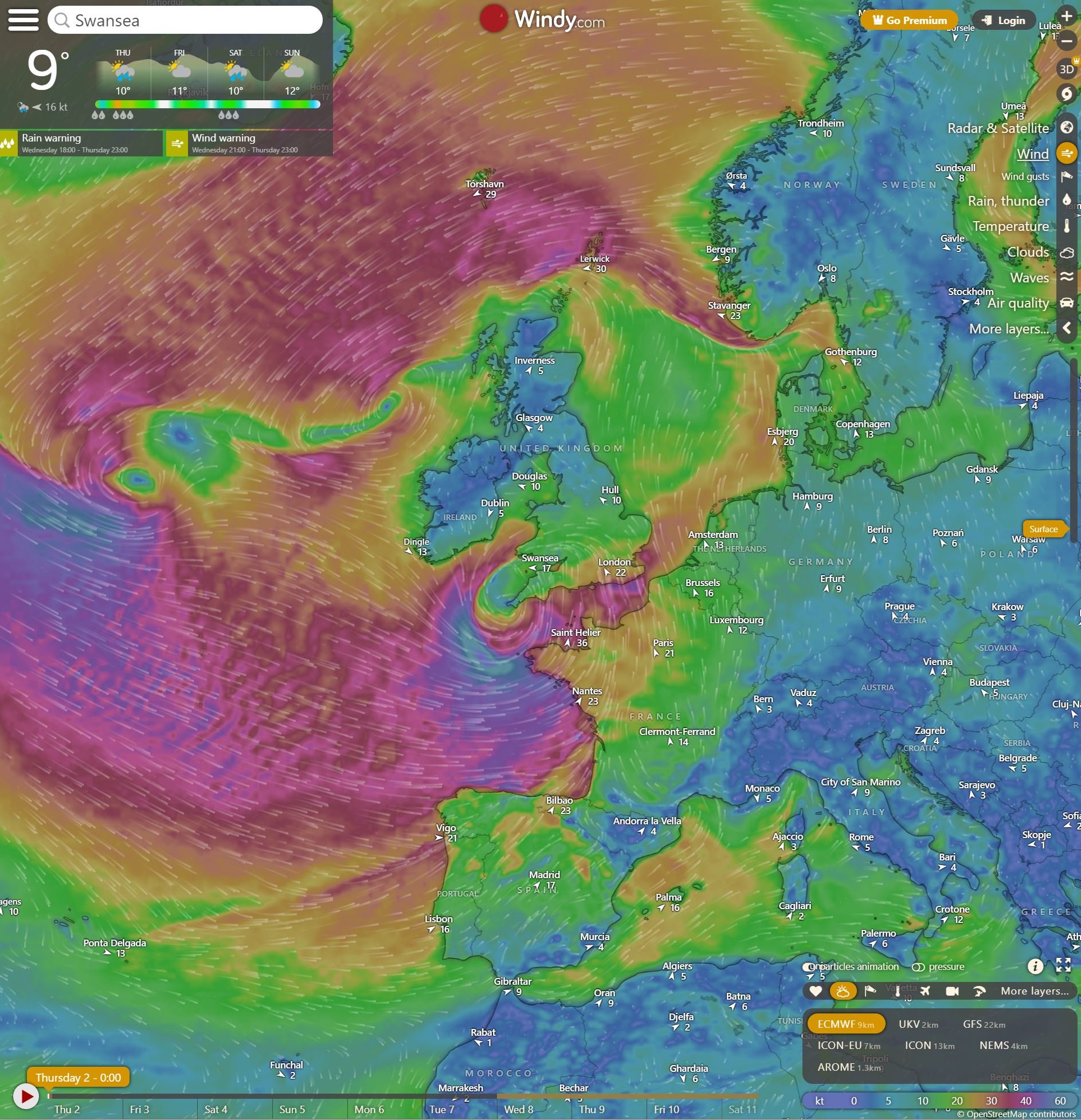
Windy
Platforms: iOS, Android
Price: Free
This is an awesome free app for weather forecast visualization.
I predominantly use its to find out the wind speed and direction. The colour chart makes its extremely easy to use and understand.
I not only use it for hiking, but also surfing, cycling and for when I want o fly my drone.
Alongside wind it also offers a 7 day forecast for waves, temperature, clouds and rain.
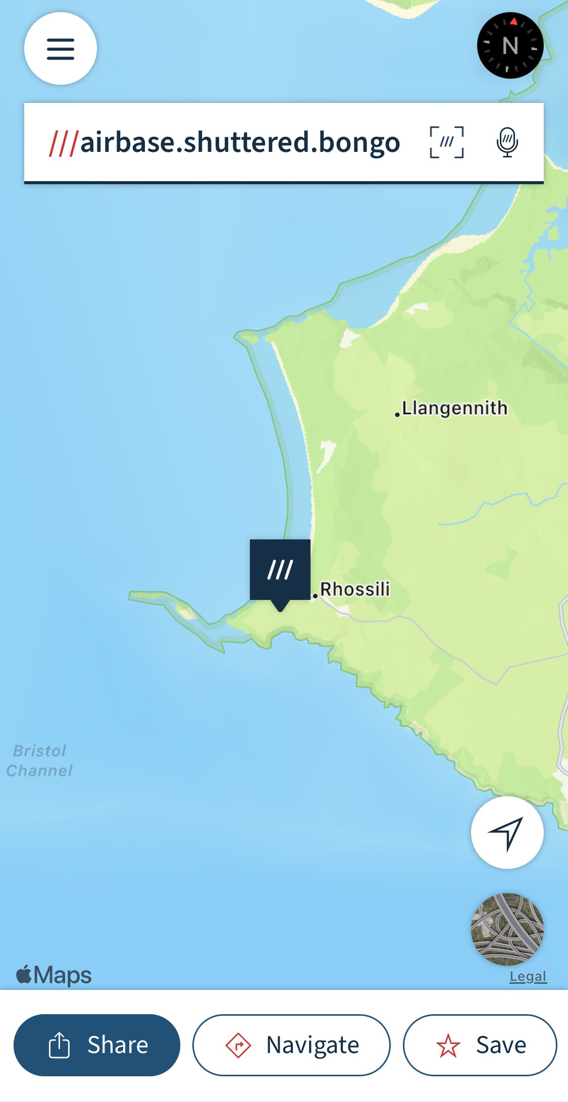
What 3 Words
Platforms: iOS, Android
Price: Free
This is an app divided the world into 3m squares and given each square a unique combination of three words.
I use this app for finding and sharing the exact location of car parks and certain topographic features such as waterfalls.
It features heavily on my blog posts as sometime a google maps location will just lead you to a very broad area.
It’s also there in case of emergencies, as three words are far easier to say and share than GPS co-ordinates.
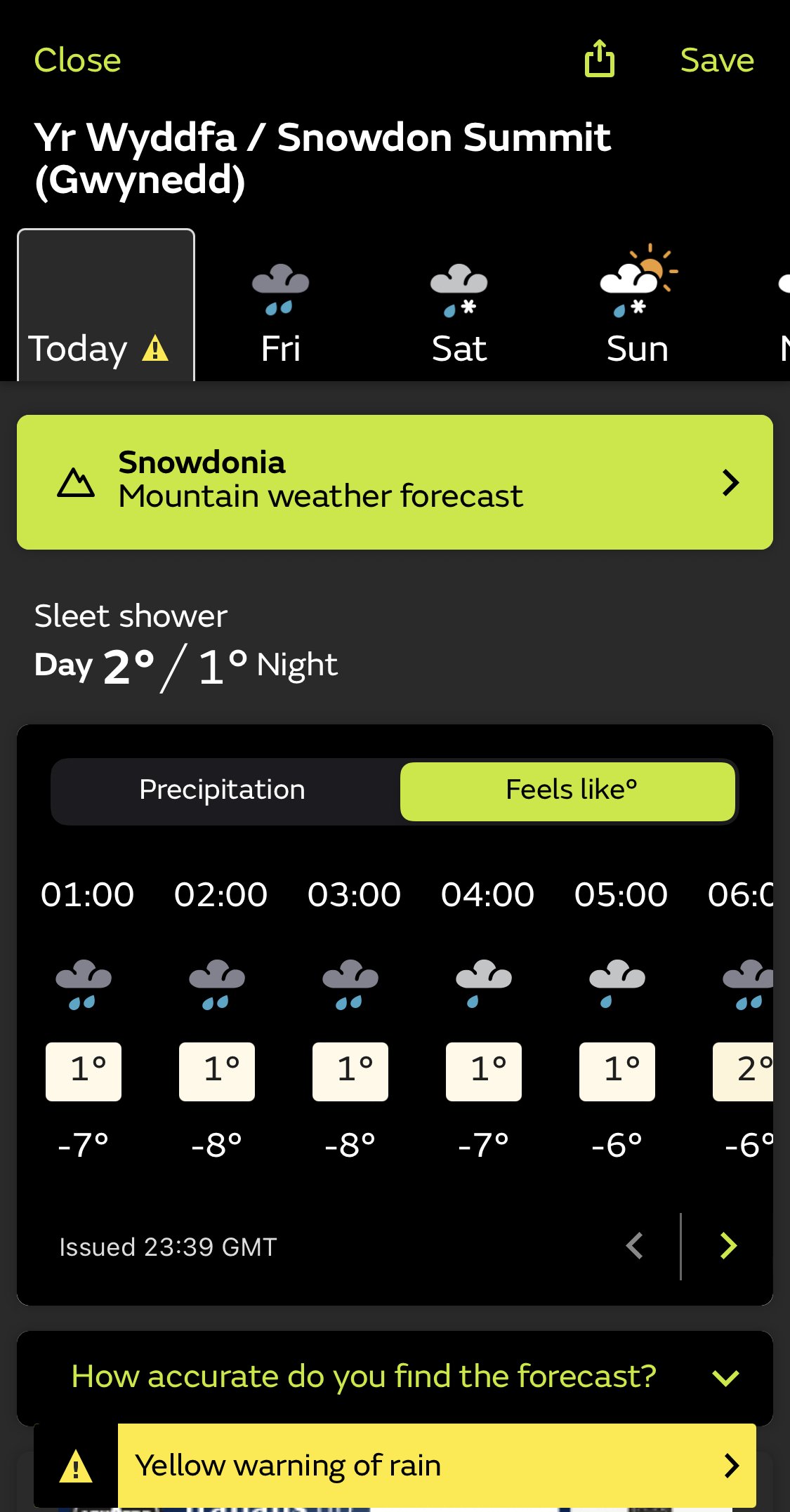
Met Office
Platforms: iOS, Android
Price: Free
Now I always take weather forecasts with a pinch of salt and tend to cross check them over multiple sites. However the Met office is the one I rely on most for outdoor and mountain weather forecasts.
The Met Office (Meteorological Office) is the United Kingdom's national weather service and the weather app gives you the accurate global weather forecasts, from 1 hour to 7 days ahead.
its easy to read and understand and gives you the ability to search the weather forecast for the summit of a mountain,
It will also show you ‘Feels like’ temperature, visibility, alongside giving you sunrise and sunset time.
I will always cross check this forecast with that of the Mountain Weather Information Service (MWIS) which is the next on my list.
Mountain Forecast Viewer
Platforms: Android unavailable on iOS
Price: Free
The Mountain Weather Information Service (MWIS) provides short term weather forecasts to aid mountain safety for the 10 mountainous regions across the UK.
Their forecasts contain detailed and accessible information which is very easy to read and understand.
The forecasts are largely in the form of warnings and they use wording that indicates the impact of the weather on the user.
Unfortunately their app is only available on android. If you are an Apple user would recommend bookmarking their website and using it as the information is priceless

OS Locate
Platforms: iOS, Android
Price: Free
A awesome emergency app which I am yet to use but i will always have on my phone.
OS Locate is a fast and highly accurate means of pinpointing your exact location on the map, anywhere in Great Britain.
The App does not require a mobile signal to function – the inbuilt GPS system can be relied upon, even in the most remote areas. The app converts GPS location readings from your mobile phone to Ordnance Survey National Grid references or Lat/Long, enabling you to determine precisely where you are on an Ordnance Survey map.
Unfortunately OS are phasing this app out and will build it into their OS Maps app. if you have it downloaded it will still remain useable so get it before its gone.

So there we have it, the 7 apps I use in the outdoors and ones I recommend you download and use.
Remember to use your best judgement, never be solely reliant on your mobile phone, and always carry a powerbank and charging cable.
Did you find the blog useful? Let me know your thoughts in the comments below.
If you did find the blog helpful, I’d appreciate you giving it a share or giving me a follow on social media, every bit of support goes a long way.
For more hiking inspiration check out my other guides below
For some Welsh travel inspiration check out my in-depth guides to each of my favourite Welsh regions below.

Find me on Instagram


