
Moel Siabod Hike Guide | Snowdonia National Park
Moel Siabod might not be the tallest mountain in Snowdonia, but it more than makes up for it with the views.
Standing at 872m, this solitary peak offers one of the best panoramas in the National Park. On a clear day, you can see 13 of the 14 Welsh 3,000s, including a front row view of Snowdon.
This 10km hike packs in everything, a solid climb, optional light scrambling, and even a pass by historic slate mines, all without the crowds you will find on the more popular routes. If you are looking for a quieter but equally rewarding day in the mountains, this is a great choice.
Key information
Summits: Moel Siabod (872m)
Route Length : 6 Miles / 9.2 Km
Hike Duration: 3.5 to 5 hours
Elevation Gain: 738m
Route Difficulty: Moderate
Parking & Start point:Bryn-Glo B & B, Pont Cyfyng

Where to park for Moel Siabod?
Free Parking is available in the car park next to Bryn Glow B&B. There’s space for around 25 cars and it usually fills up quickly so get there early to snag a space. If the car park is full you will have to source a legal alternative location in one of the lay-bys on the side of the A5.
Is Moel Siabod an easy hike?
Moel Siabod is not a technical climb, but it is still a proper mountain day. The route includes around 800m of elevation gain and a short section of light scrambling near the summit.
If you have a good level of fitness and some mountain experience, you should not find it overly difficult. However, it is not a beginner-friendly walk and should not be underestimated, especially in poor weather.
How long does it take to climb Moel Siabod?
Most people complete the hike in between 3.5 and 5.5 hours.
Your time will depend on your fitness, pace, and how long you spend at the summit taking in the views. On a clear day, it is well worth slowing down to enjoy the panorama.
Are there toilets on the route?
There are no toilets at the start point or anywhere along the route.
The nearest facilities are at the Moel Siabod Café, located roughly one mile north of the main car park. It is a great spot to stop before or after your hike for food, drinks, and a proper bathroom break.
Do you need scrambling experience?
The Daear Ddu ridge includes a short section of light scrambling near the summit.
It is nothing compared to routes like Crib Goch, but you will need to use your hands and be comfortable on rocky terrain. In dry conditions, most people with basic mountain experience will be fine.
In wet or windy weather, this section can feel much more exposed, so extra care is needed.
Is Moel Siabod worth it?
Absolutely.
Despite being lower than many surrounding peaks, Moel Siabod offers one of the best viewpoints in Snowdonia. Its isolated position gives you uninterrupted views in every direction, including a full panorama of the Snowdon massif.
If you want big mountain views without the crowds, this is one of the best hikes in the area.
What to take
Even on a clear day, this is still a mountain environment. Make sure you bring:
Waterproof jacket
Warm layers
Map or GPS route downloaded
Plenty of food and water
Good hiking boots with grip
Conditions can change quickly, so it is always better to be overprepared than underprepared.

The Route
From the car park, cross the road and head up the A5. After passing the impressive Cyfyng waterfall turn left and crossover the stone footbridge. After around 300m the road will fork, turn right over the cattle grid and follow the path as it climbs steeply up past Rhos farm.
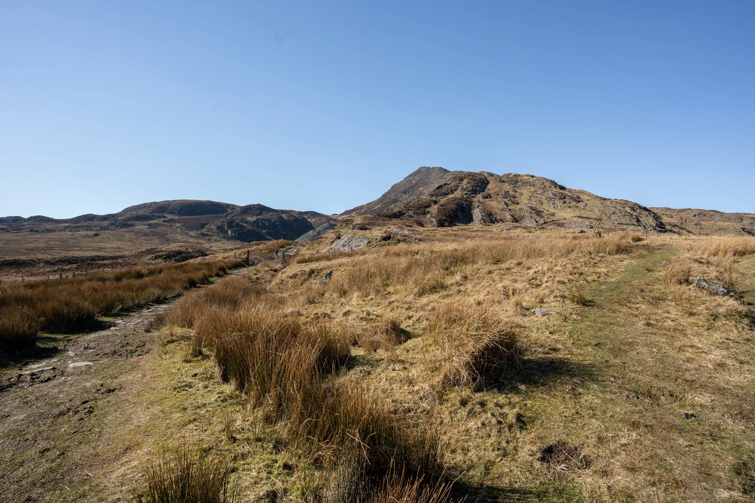
After passing the farm and over a second stile, Moel Siabod will come into view. After half a kilometre following a rocky path, the route will fork.
If you head left it will take you through the slate quarries and up the Daear Ddu Ridge to the summit (clockwise route) , proceeding straight ahead will take you straight up the crest of the mountain (anticlockwise route).

As i’d recommend tackling this in a clockwise fashion, head left and follow the path as it passes a reservoir into the abandoned Moel Siabod slate quarry.
Shut down in 1884, the complex comprises a series of ruined buildings and trackways, a large quarry (now flooded) and extensive slate spoil heaps. The areas is wonderfully tranquil so take some time to poke your head around and explore its ruins.
If you branch off to the left of the path shortly before the flooded quarry, you will be able to find two former quarry buildings with slate roofs which remain partly intact. They offer a terrific views back towards Pony Cyfyng and in more recent times have become a bit of an Instagram hotspot.


Once down the ridge, you will have to navigate by the boggy marshland which passes by Llyn-y-Foel. Depending on the time of year and the prior weather you may have to make a few detours to avoid the overly saturated areas.
Daear Ddu Ridge is apparently classed as a grade 1 scramble, however I feel that grading is very generous. You can easily pick your way up the ridge, carefully following the more well trodden route.
For those who are seeking a little more excitement and exposure, you can make the ascent more difficult by choosing to scramble and climb directly up the spine of the ridge.
After half a mile you will eventually emerge onto the summit of Moel Siabod
The English translation for Moel Siabod is “Bare mountain” and it’s clear to see why.
Beneath the trig pillar lies a wide rocky outcrop covered in large boulders. It’s similar to the Glyderau and can be a little underfoot tricky to navigate, especially in the wind and rain.
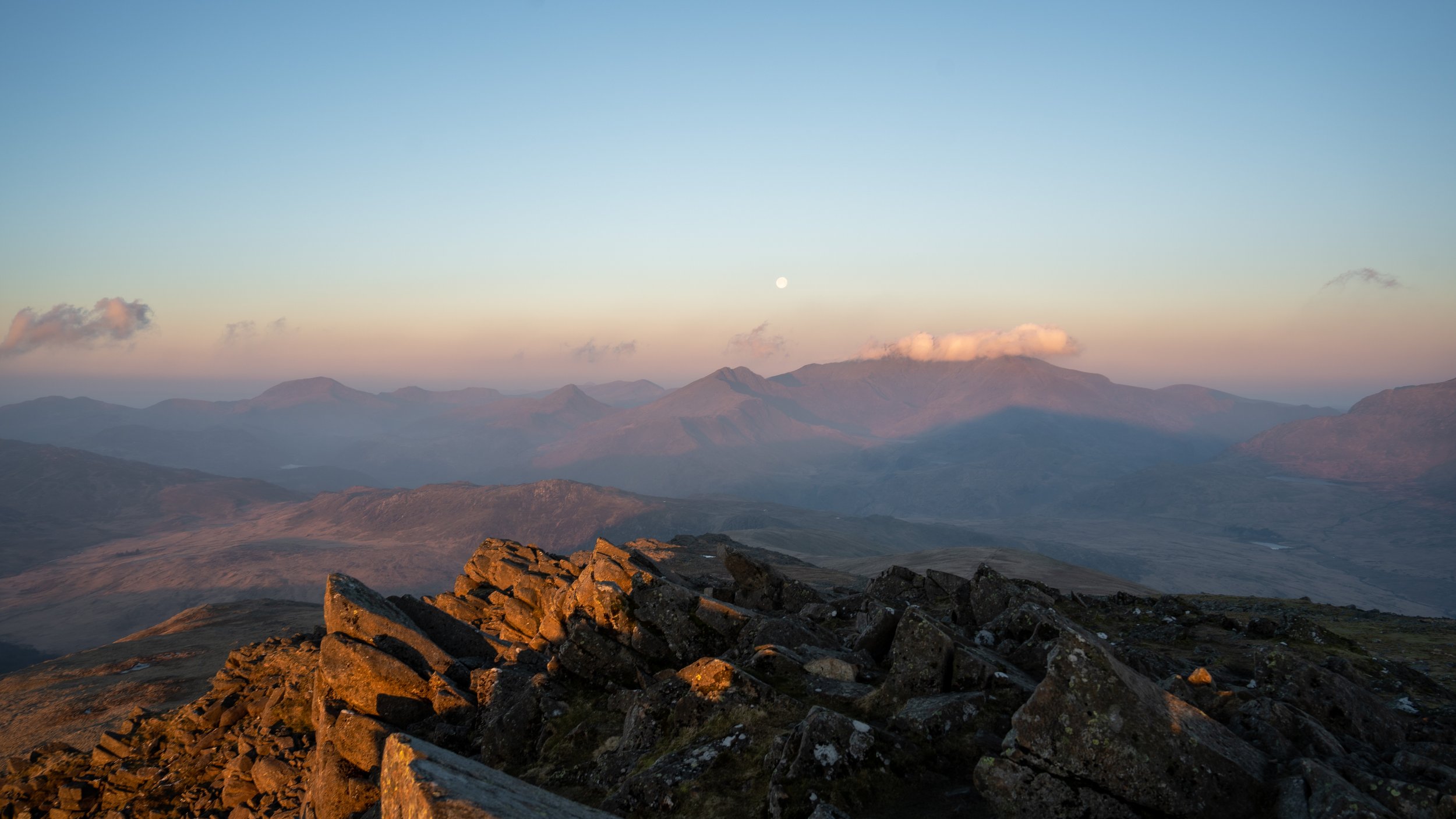
The summit itself is marked by a trig point, from which you have majestical 360 degree panoramic views across the national park


Looking north you have the Snowdon massif, the Glyderau, and Carneddau with the indistinguishable sharks fin shaped Tryfan clearly noticeable between them. Looking east you have the Llyn peninsula and Ceridigion bay and to the south you can see the Rhinogs and the mighty Cadair Idris.
Once you have taken in the stupendous views its time to make your descent. Head east, past the circular stone wall shelter which lies slightly off the summit.
You can either follow the long flat rocky ridge-line north east east for around 800m before scrambling your way down to the main path.
Or if you want an easier route, head left and follow the path off the ridge as it moves from rock onto grass and weaves around the side of the mountain. Cross over a wooden style and follow the wide grassy path as heads north east. After a couple of hundred meters the route will descend down the rocky eastern face of the mountain.
The path is quite steep and fluctuates between grass, rock, and scree. On occasions you may have to use your hands, but I wouldn’t class it as scrambling.
Once at the bottom, cross over the wooden stile, rejoin the initial path and retrace your steps back past Rhos Farm to your car.


Looking back towards Snowdon on the descent
Final thoughts
Moel siabod took me by surprise. Not only were the views from its summit majestical and some of the best in the national park, but the variety of the terrain and features throughout the walk alongside the lack of people made it a hike to remember.
It’s a hike which is worthy of your time and one you should look to tackle if you are in the national park for a few days. I tackled it an anticlockwise fashion as I was short on time and wanted to get to the summit for sunset, however if I was to do it again I was complete it clockwise fashion which i have outlined in the blog so I could scramble up the Daear Ddu ridge.
Having wildcamped on the summit it’s a great place to watch both the sunset and sunrise. I’d also recommend Stopping by Moel Siabod café once you finish the hike to replenish all those calories you have burnt.
HELP SUPPORT MY WEBSITE
I created and I run this website in order to help inform, amaze, inspire people (for free) to get outside and explore the adventurous side of the UK and beyond.
If you’d like to support this website, you can use the affiliate links below to book your accommodation or transport. These come at no extra cost to you, but help keep this site running.
Book your car using Discover Cars
Book your accommodation using Booking.com
If you are feeling generous you can also buy me a coffee to say thank you, and give me a follow-on social media.
Thank you, and if you have any questions, leave them in the comments below or drop me an email.
You can find more Snowdonia and North Wales inspiration in the following blogs
The must-visit photography spots in Snowdonia National Park
The best places to watch the sunrise in Snowdonia National Park
The 10 best places to watch the sunset in Snowdonia National Park & North Wales
Hike Guides
For more Welsh travel inspiration check out my in-depth guides to each of my favourite Welsh regions below.

Find me on Instagram


