
Central Brecon Beacons circuit hike guide
The monster 20km loop summits south Wales two highest peaks; Corn Du (873m), Pen-Y-Fan (886) and encompasses everything which is great about the central Beacons, including panoramic vistas, wonderful waterfalls, sweeping glacial ridgelines, and even the visit wreckage of a WWII plane.
Alongside a circuit of the Llyn -y-fan’s, this is arguably the best day hike in the Brecon Beacons national park. So if you are coming to tackle one big hike in the central Brecon beacons, make sure it is this one.
Key information
Summits: Pen- y-Fan (886m), Corn Du (873m), Cribyn (795m), Fan-y-Big (717m)
Route Length : 13 miles / 20 km
Hike Duration: 6 to 9 hours
Elevation Gain: 830m / 2,725 ft
Route Difficulty: Very hard
Technical elements - Some steep climbs but no scrambling
Parking & Start point: Blaen y Glyn Uchaf Car Park
Where to park
Parking is available in at either the upper (Uchaf) or the lower (Isaf) Blaen y Glyn car parks located between the Pontsticill and Talybont reservoirs. Alternatively you can park at the Neuadd car park in the Taf Fechan forest (Postcode CF48 2UT) which is the start point for the Pen-y-fan horse shoe.
Both car parks are free but are accessed by down narrow single track roads alongside reservoirs. At times this can feel like you’re heading into the middle of nowhere but trust the postcodes and you will eventually reach the car parks.
Things to note before starting this walk
This is difficult hike which will take between 6-9 hours. I would recommend picking a dry and clear day, starting nice and early, and packing plenty of a food and water.
There are no toilets or facilities on this route or at the car parks.
You can complete this hike in either direction. For the best views head in an anti-clockwise heading up the Blaen-y-glyn waterfalls first
You can take a dip in the Blaen-y-glyn waterfalls so it would be worth leaving some swimwear and a towel in the car and having a post hike dip once you finish.
The South Wales mountain weather can be fickle and can quickly take a turn for the worse. I’d recommend a a waterproof coat, and packing a few extra layers.
The Route
This route is a loop and can be completed in either direction. I’d recommend tackling anti- clockwise, heading up past the Blaen-y- glyn waterfalls first then hiking along the ridgeline towards Pen-y-fan.
This way you get the trickiest section out the way first and you’ll walk along the ridgeline towards the spectacular views of the highest peaks in central Beacons.
Blaen-y-Glyn Waterfalls
From the Upper Car park head down into the forest towards the waterfalls.
The path will quickly fork, the left hand route is well maintained and easy to follow, leading you around then down to the river.
The right hand path goes off trail, passing one of the bigger more impressive waterfalls. It isn’t the easiest to follow and goes over some steep and uneven ground so it may not be suitable for everyone.
Both trails end up at the impressive Blaen y Glyn waterfall (see below) So it doesn’t matter which one you take.

The Blaen-y-Glyn Waterfall
After stopping for photos, cross the wooden footbridge to the eastern side of the river and follow the right hand river bank upstream.
The path is quite narrow and can get boggy underfoot, however it is very easy to follow. On route you’ll pass several other smaller cascades with plunge pools which would be perfect for a refreshing dip. After 1.3km you’ll reach a wooden stile and a fence which extends up the valley.
Wellington Bomber War memorial
Cross the style, turn right follow the steep path that leads up the mountain alongside the fence. After 1.3km you’ll reach a stone cairn, follow the path up and along ridgeline for a further 1km until the war memorial comes into view below you.
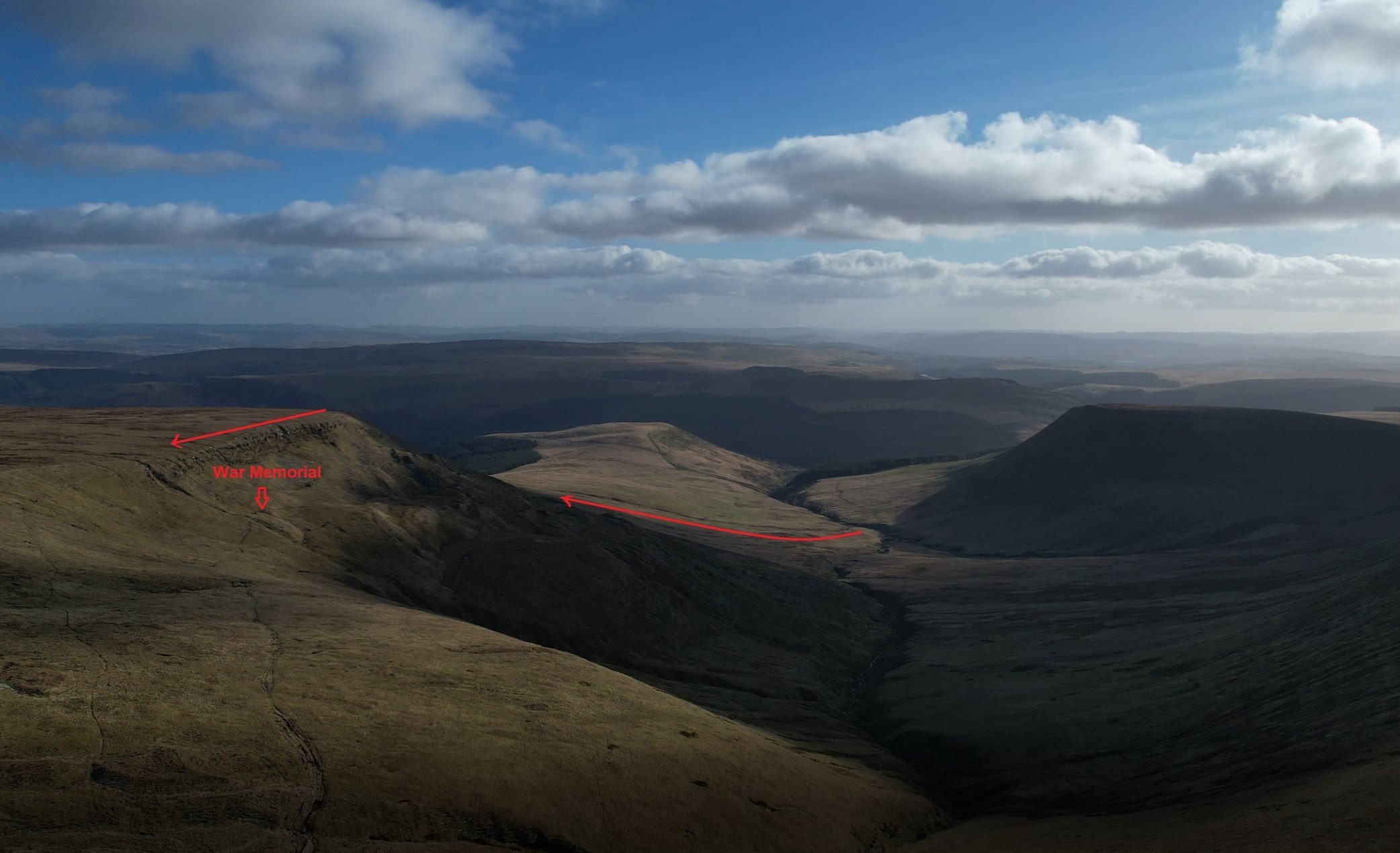
Option 2: The route up and over the ridge
30m beneath the ridge lies a stone obelisk and two piles of wreckage which mark the crash site of the Word War Two Wellington Bomber. The plane crashed into the mountainside under poor weather conditions in July 1942, killing all five of its Canadian crew members.

A panorama of the valley from on top of the ridge

The view of the memorial and Pen-y-fan from the ridge

The stone memorial
The good news is that difficult part of the hike is now out of the way and from here you will be treated to (hopefully) spectacular views.
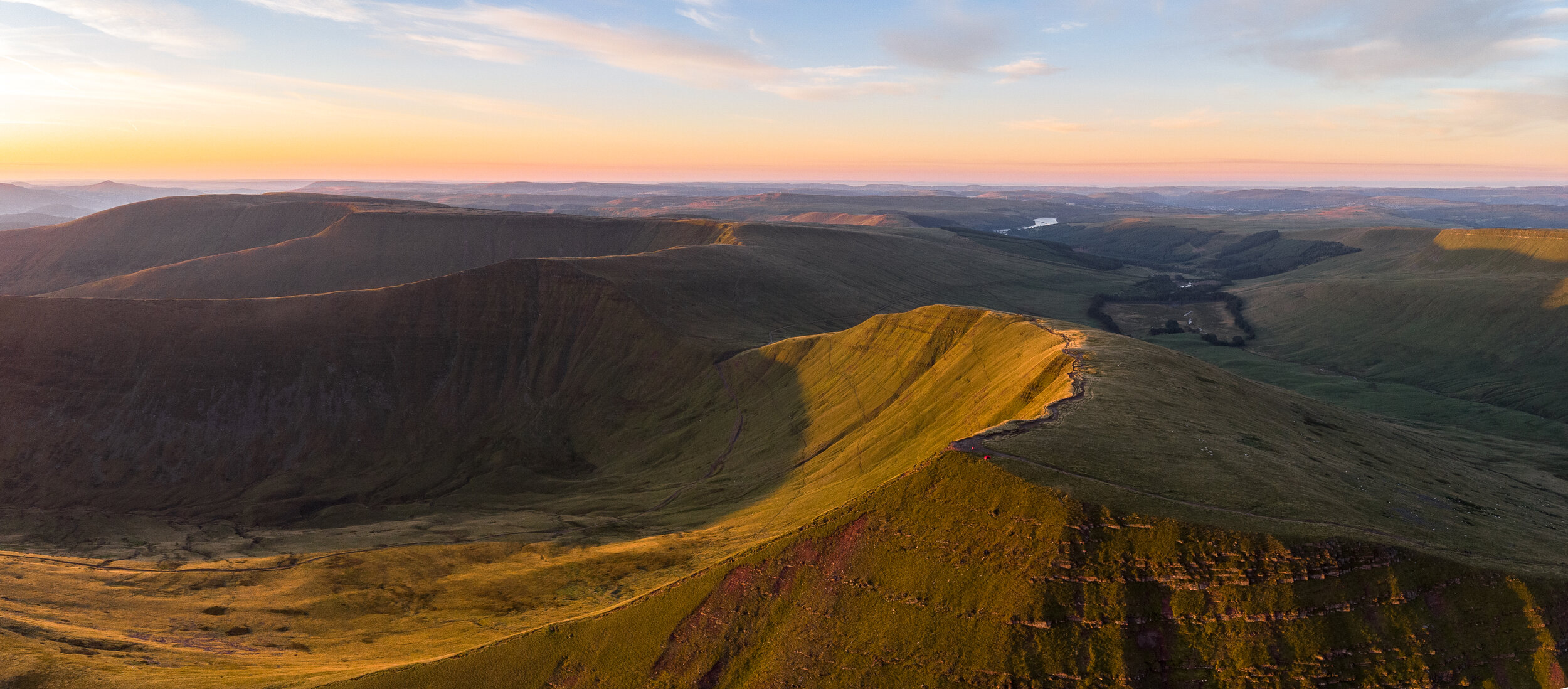
From the memorial follow the distinct path northwards, after around 700m you’ll eventually reach a saddle where several paths meet. Work your way onto the north side of the saddle and turn left following the Bwlch y Ddwyallt ridge as it curves westwards towards the peaks of Pen-y-fan

The view from Bwlch y Ddwyallt
Bwlch y Ddwyallt
Curved glacial escarpments drop sharply beneath you and lead out towards the mighty peaks of Pen-y-Fan, Corn Du and Cribyn. There’s more layers than a Viennetta and you could argue that these views are some of the best in the Brecon Beacons.
Even though I have done this walk before I couldn’t help but be astonished by the insane mountain views you get when you come up and over the saddle. Take you time and enjoy it as the views are magnificent.

Craig Cwareli
Follow the ribbon like ridgeline weaves its way westwards for just under a kilometre, before heading southwards towards Craig Cwareli. Although you may not have thought it was possible, the views continue to get better and you will find yourself stopping very couple of 100m to take a photo.

Fan-y-Big
After 2 miles of ridge walking you’ll reach the 717m high, hilariously named Fan-y-big. Although the mountain isn’t the highest and the views aren’t quite as dramatic as those from Pen-y-fan or Cribyn, the peak is still impressive in its own right.
The summit is marked by a large stone slab which resembles a diving board. Its a perfect peak to escape the crowds and grab a rather daredevil like photo.
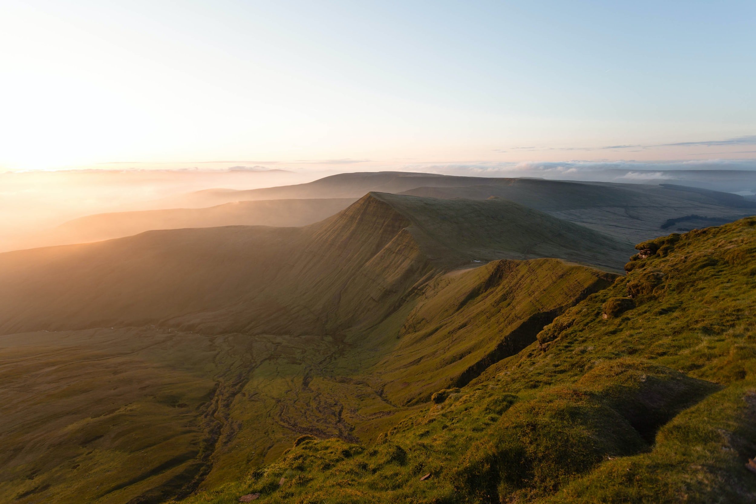
Cribyn
From Fan -y-Big , descend the very steep slope down to the gap, a bridleway which cuts through the saddle. There’s no rest here, as you head straight back up the other side. The path is savagely steep but is broken into three distinct climbs before levelling off.
After just over a kilometre you will reach the summit and the reward would be incredible views towards Pen-y-fan and back across the central beacons, see below for proof.
I’d recommend taking the time to stop here if you can as there will be a fraction of the crowds on the summit compared to Pen-y-fan.

Looking back towards the layers of the central beacons
Pen-y-Fan
From Cribyn drop straight down to the saddle before ascending the steepest and last climb up the hike up to Pen-y-fan.
I have a love hate relationship with this peak. I love its accessibility and the sensational views it lays claim too, but on the other hand its always busy, no matter the time of year or day.
Whatever my thoughts, you can’t argue that the views eastwards back towards Cribyn aren’t some of the most impressive in the national park. Take the time to enjoy them before heading south-eastwards towards the twin peak of Corn Du.


Corn Du
Corn Du is the neighbouring twin peak of Pen y Fan and the second highest peak in South Wales at 873 m.
The summit is very similar to that of Pen y Fan: flat and anvil-shaped and marked by a well structured Bronze Age cairn.
You can either go up and over the summit or skirt round to its left, skipping it altogether. Although the views so match that of its twin, its still worthy of the short climb to its summit,.
looking at Corn du from Pen-y-fan
The view from Corn Diu looking west
Returning to your car
From Corn du pass by the saddle. ignoring the motorway down to your left and continuing straight on. Once up on the ridge of Craig-Gwaun-Taf, follow it south for for 3km until you see a steep path to you left leading down to the Lower Neuadd Reservoir.
Drop down to the reservoir, pass its base then turn right, following the path down towards the Taf Fechan car park. Upon reaching a metal swing gate the path will fork.
Follow the grassy/ gravel path up to the left for 2.7km as it swings around the mountainside, then drops onto the road before heading back towards the Blaen-y-glyn waterfalls.
Looking back at Corn Du, Pen-yfan and cribyn from Craig-Gwaun-Taf

The steep path down to Lower Neuadd Reservoir
Help support my website
There we go, a guide to the Pen y Fan Six challenge. Let me know in the comments if you want to give it a go, if you have any questions and if have completed it, what your time was.
I created and run this website in order to help inform, amaze, inspire people (for free) to get outside and explore the adventurous side of the UK.
Although I do run some google ads, I have limited them in order to make your experience on this website far more enjoyable.
If you’d like to support this website, you can use the affiliate links below to book your accommodation or transport. These come at no extra cost to you, but help keep this site running.
Book your vehicle using Discover Cars
Book your accommodation using Booking.com and Sykes Cottages
If you are feeling generous you can also Buy me a Coffee to say thank you, and give me a follow on social media.
Thank you, and if you have any questions, leave them in the comments below or drop me an email!
For more hiking inspiration check out my other guides to the Brecon Beacons below.
Central Brecon Beacons
Western Brecon Beacons
Waterfall Country
Eastern Brecon Beacons

Find me on Instagram


