
Cwm Llwch Horseshoe hike Guide - the Best Route up Pen y Fan

Standing at 886 m (2,907 ft), Pen y Fan is the highest peak in Bannau Brycheiniog (Brecon Beacons) National Park, and hiking it is a must-do experience when visiting South Wales.
If you’re looking for the most scenic and rewarding way to reach the summit, the Cwm Llwch Horseshoe is hard to beat.
This circular route begins on the quieter northern side of the Brecon Beacons, guiding you through a sheltered valley, past waterfalls and the glacial Cwm Llwch lake, before climbing along dramatic ridgelines to summit both Corn Du and Pen y Fan.
Unlike the busier paths from Storey Arms or Pont ar Daf, the Cwm Llwch Horseshoe offers a far more peaceful ascent — perfect if you want to escape the crowds. It’s also an excellent choice for an afternoon hike, with the chance to time your descent for a spectacular Brecon Beacons sunset.
Key Hike Info
Hike Type: Loop
Difficulty: Moderate
Distance: 11km
Elevation Gain: 700m
Estimated Time: 3-5 hours
Terrain: Stony path, Grass, and gravel
Start Point and Parking: Cwm Gwdi National Trust or Nant Cwm Llwch Car Park
where to park?
I would recommend parking ta Cwm Gwdi and completing this loop anti clockwise. This way you start with the short section of road walking.
Limited paid parking is available in Cwm Gwdi National Trust (strangely this isn’t listed on Google). Again, it fills up quickly on weekends so arrive early or in the afternoon.
Additional parking is available at Nant Cwm Llwch Car Park in a rocky and grassy farmers field, again it can fill up quickly on weekends. You can also camp here for £5 per person
The roads to both car parks are single track and very narrow so take care driving them.
What should I wear to hike Pen y fan?
This will be dependant on the weather conditions and season you are hiking in, alongside your own physiology.
Always check the weather forecast for mountain you are hiking. I would recommend using the on the Met Office website and MWIS playing close attention to the following things:
Feels like temperature at the summit
Chance of Rain
Visibility/ Chance of cloud free peaks
Wind speed
These four things will dictate what you wear and carry. While it is only a short hike, it will be colder and windier at the top than at the car park, so it’s better to carry extra layers/waterproofs just in case.
Essentials
Grippy and stable footwear: I recommend Walking boots from Adidas, My favourite being the Freehiker 2 GTX
Layering system: 2-4 layers for your top half
Base layer (T-shirt)
Mid layer (Fleece or hoodie)
Outer shell (Wind breaker or waterproof)
Fourth layer in winter (Insulated jacket)
A Hiking/ Navigation app with the route downloaded for offline use: I use and recommend OS Maps
Other things
Fluid + snacks
Backpack to carry your spare layers, water, and snacks
Gloves, beanie, and face buff
Head torch (If heading up at sunrise or sunset)
Powerbank and charging cable
Hiking Poles
Microspikes (in winter)

The route
Starting from the Cwm Gwdi car park, walk back down down the driveway to the road and turn left. Follow the quiet lanes for around 2.3km always until you reach a cattle gate marking the start of the Cwm Llwch valley.
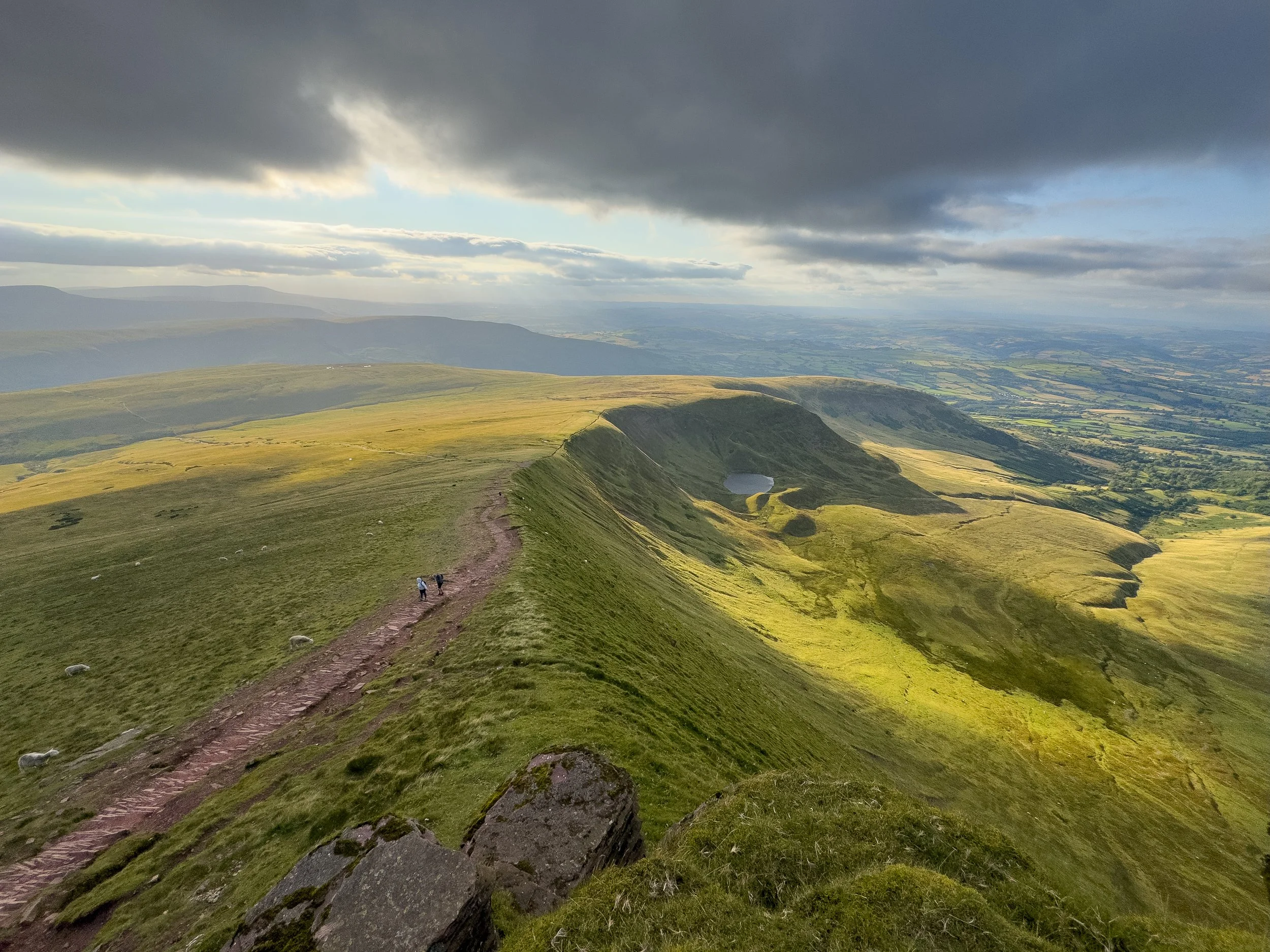
Beyond the gate, a stony track runs beside the Nant Cwm Llwch stream; the path climbs gently through fields and past farm buildings. Pass to the right of a cottage and cross a stile, and you’ll emerge onto open hillside where the path steepens and heads into the glacial valley.
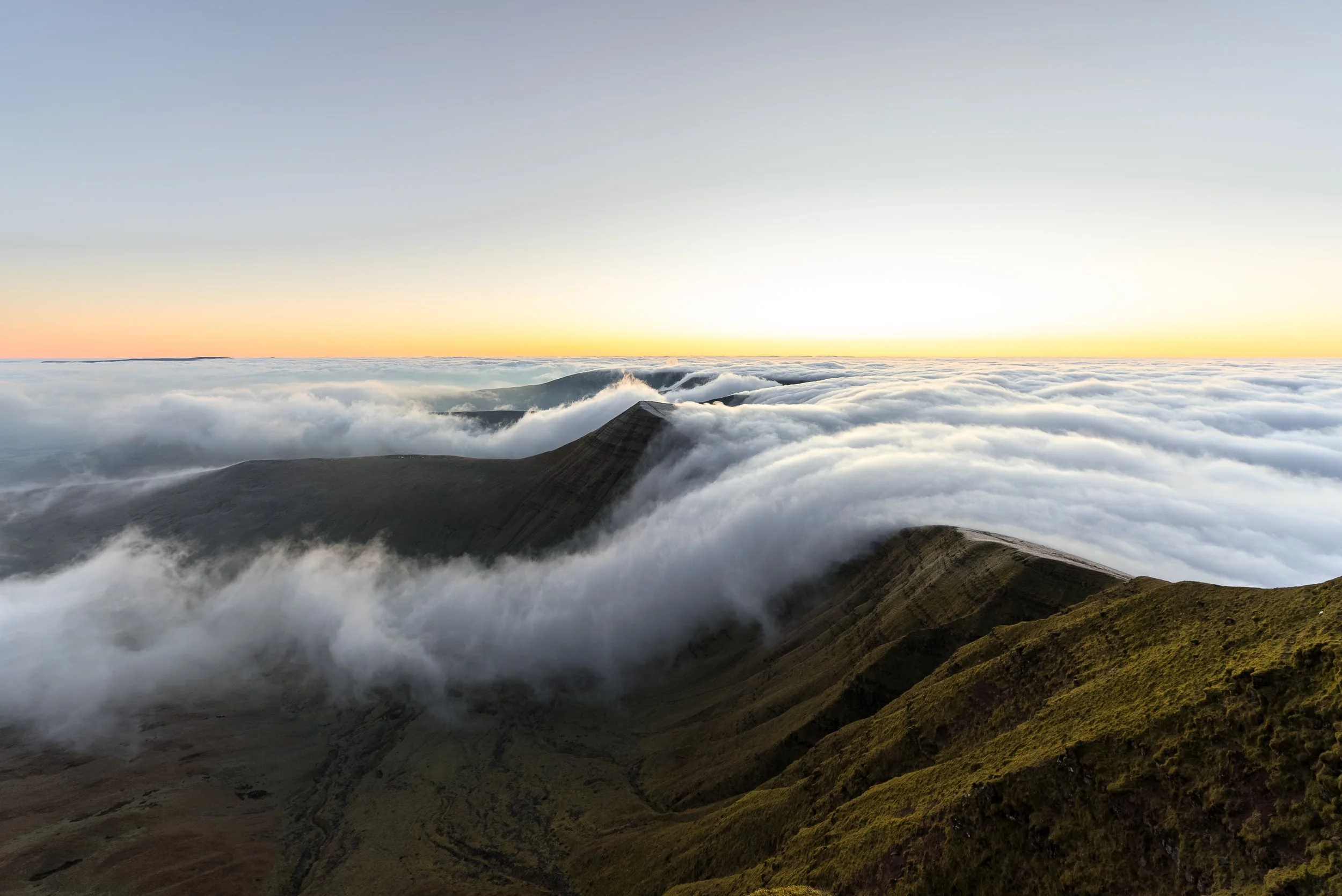
After a short, flatter section, climb up to the glacial lake of Llyn Cwm Llwch and continue steeply to a saddle marked by the Tommy Jones memorial obelisk. Take a moment here to catch your breath and enjoy the views across the western Beacons. From the obelisk, a final steep ascent leads to the summit of Corn Du, where you can look back over the valley and the lake below.


The view looking north west from Corn Du, the Cwm Llwch valley is to the right
After summiting Corn Du, drop down to the saddle and then make the short final climb to the summit of Pen y Fan.
Pause here to soak in the views, the panorama across the Brecon Beacons is spectacular, especially looking east towards Cribyn and the weaving ridgelines of the central peaks.
For the descent, follow the northern ridgeline down and along Cefn Cwm Llwch. Theintial section from Pen y Fan is steep and rocky, but it soon levels out onto a broad grassy ridge.
When descending the wide ridge,tTake your time to turn around and admire the view; you’ll see the sheer north face of Cribyn and sweeping vistas of both the eastern and western Beacons.
The well‑defined path continues north, skirting the crest of the hill, and eventually dropping down more steeply back towards Cwm Gwdi, You’ll pass over a style and through a gate before you get back to the car park.


Pen y Fan FAQ’s
When is the best time to hike Pen y Fan?
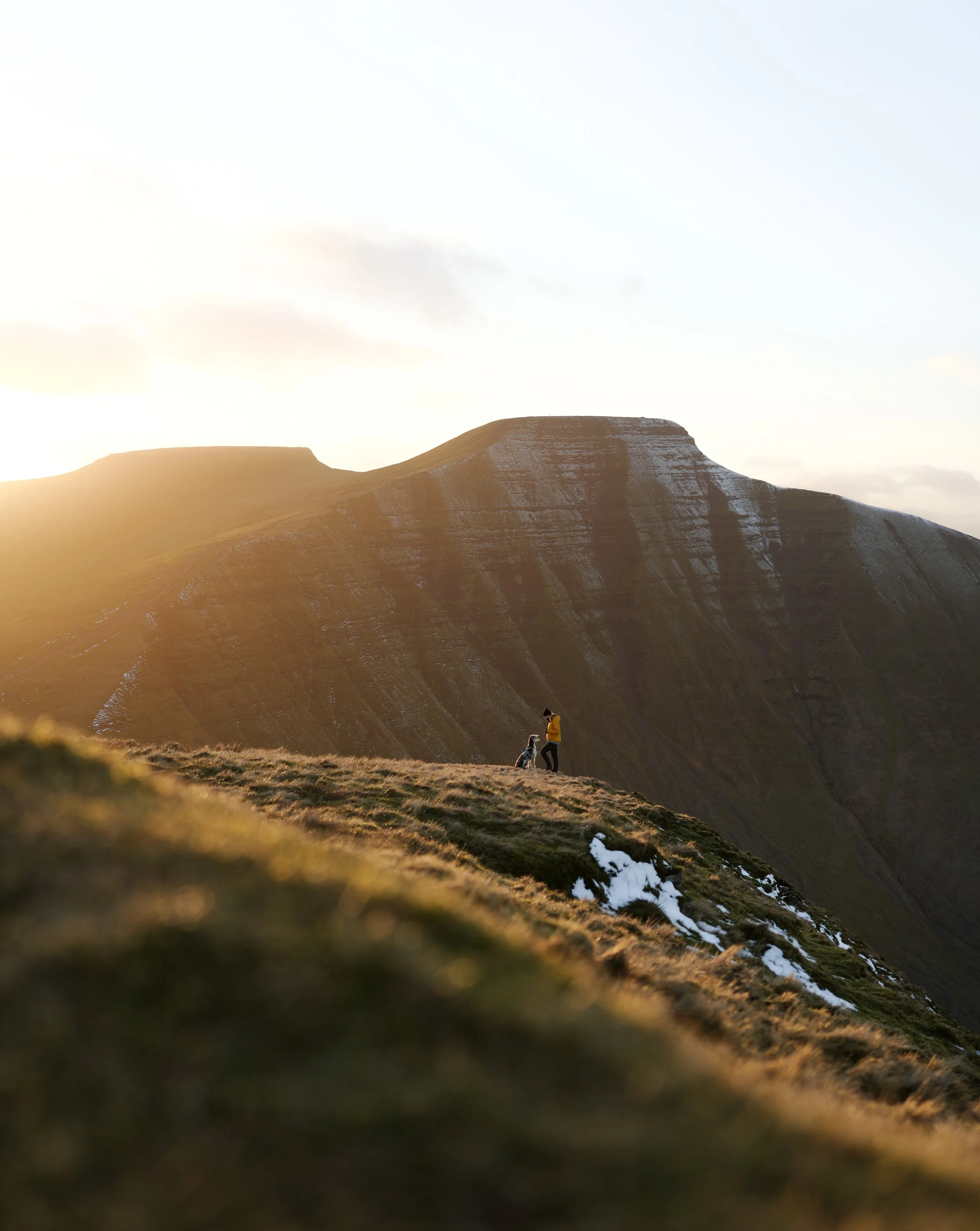
In terms of time of day, sunrise is incredibly beautiful, especially as the sun rises from the east, so you have a view over the ridgelines of the central Beacons. Unfortunately it is incredibly busy at sunrise, with hundreds of people flocking here and the main car park at Pont ar Daf is often full
Because of this I recommend heading up Pen y Fan for sunset, although you dont get as good as a view as sunrise, its still a scenic and beautiful experience. the summit will be significantly quieter (often less than a dozen people) and in my opinion much more enjoyable. Whats more you wont have to get up super early and will easily be able to find a parking space.
If you do head up for sunrise or sunset, pack extra layers and a headtorch.
In terms of seasons, Pen y fan is beautiful year round, however is extra special under a blanket of snow., so hikign it in Winter can be a rewarding experience. Always check the weather forecast on MWIS and Met Office, wear and carry the correct clothing and kit, and consider buying Mini Crampons/ Micro spikes.


-
Pen y Fan stands at 886 m (2,907 ft), and is the highest point in Bannau Brycheiniog (Brecon Beacons) National Park and South Wales
-
In my opinion it would be the Cwm Llwch Horseshoe. Its incredibly scenic, passes a variety of landscapes and is much quieter than other routes.
If you are looking for the best out and back route then that would be Pen y Fan from Cwm Gwdi via Cefn Cwm Llwch.
If you want to summit multiple peaks (such as Cribyn and Fan y big) then I would recommend the Pen y Fan Horseshoe or the Circuit of the Central Beacons.
-
That would be Pen y Fan from Pont ar Daf.
It is the shortest route with the least elevation gain. It is 3,2km one way, climbs steadily to the summit via well built path and involves 454 m of elation gain.
Active children can manage it and should take between 45-90 minutes one way.
-
The hardest direct route to the summit of Pen y Fan is from Nant Cwm Llwch, as this has the most elevation gain.
However, the Pen y Fan horseshoe is considered more challenging (14km / 800m of elevation) as it involves summiting other peaks.
If you want a tough day in the hills consider hiking the Circuit of the Central Brecon Beacons (21km / 1,086m of elevation) or the Pen y Fan Six Ways ( 32km, 1,800m Elevation)
-
There are National Trust car parks at Pont ar Daf Car Park and Storey Arms (west), Cwm Gwdi National Trust or Nant Cwm Llwch Car Park (noth); You can also park at the Neuadd car Park in the Taf Fechan Forest for the horseshoe.
-
Allow 3–8 hours, depending on the route and your fitness. The gentle path from Storey Arms or Pont ar Daf is 4 mi/6.5 km involves 454m of elevation gain and takes 3–4 hours; longer circuits via Cwm Llwch or the Horseshoe Ridge take 5–8 hours
-
You can hike Pen y Fan alone. The peak is so busy there will always be another person hiking it. The most popular route is from Pont ar Daf.
-
There are no toilets on the mountain or summit; the only toilets are at Pont‑ar‑Daf car park.
-
Yes, dogs are welcome but must be on a lead and under control.
-
Yes. Pen y Fan is significantly easier than hiking Yr Wyddfa (Snowdon). The routes are musch shorter, less rugged and involve less elevation gain.
-
In dry conditions you can hike up Pen y Fan in trainers, especially if you are hiking from Pont ar Daf However in the wetter conditions and winter I would recommend hiking shoes/boots or trail runners with better grip.
-
Brecon is the nearest town (about six miles north of the main trailheads), offering shops, cafés and accommodation.
Help support what I do
I created and I run this website in order to help inform, amaze, inspire people (for free) to get outside and explore the adventurous side of the UK and beyond.
Although I do run some google ads, I have limited them in order to make your experience on this website far more enjoyable.
If you’d like to support this website, you can use the affiliate links below to book your accommodation or transport. These come at no extra cost to you, but help keep this site running.
Book your car using Discover Cars
Book your accommodation using Booking.com and Sykes Cottages
If you are feeling generous you can also Buy me a Coffee to say thank you, and give me a follow on social media.
Thank you, and if you have any questions, leave them in the comments below or drop me an email!
For more hiking inspiration check out my other guides to the Brecon Beacons below.
Central Brecon Beacons
Cwm Llwch Horseshoe
Western Brecon Beacons
Waterfall Country
Eastern Brecon Beacons
