
Waun Fach via the Dragons Back | the best day hike in the Eastern Brecon Beacons
Waun Fach via the Dragons Back is a delightful 7.5 mile circular hike located in the Black Mountains of the Eastern Brecon Beacons. The moderately hard hike isn’t at all technical and offers stupendous 360 panoramic views over three counties and the rest of the national park.
On route you’ll pass over the site of the highest castle in Britain before ascending the majestic dragons back ridgeline up to Waun Fach (811m), the highest peak in the Black mountains and the second highest in the Brecon Beacons.
It’s a superb hike and one which should definitely to be on your to do list if you are planning on visiting the National Park. As well as this blog I have also made a vlog outlining the hike below.
Key information
Summits: Waun Fach (813)
Route Length: 7.5 miles / 12 km
Hike Duration: 3.5 to 5.5 hours
Elevation Gain: 550m / 1,800 ft
Route Difficulty: Moderate
Technical elements - None
Parking & Start point: Dragons Back Hotel

Where to Park
Parking is available in a small car park on the side of the A479 just outside of Pengenffordd in the eastern section of the Brecon Beacons national park. It’s private land owned by the Dragons Back Hotel and costs £5 to park all day. You pay cash at an honesty box and there is no obligation to go and visit the hotel or pub.
The Route
The route is a moderate 7.5 mile loop which encompasses 650 meters of elevation gain. Depending on your fitness levels It should take between 3-5 hours to complete and can be hiked in a clockwise or anticlockwise direction. The route guide below guide outlines it in a clockwise fashion, ascending up the dragons back.
You can also view this hike on Komoot here
The Start
From the car park, take the path next to the large map down into the lane behind the car park. Once in the lane, turn right and after 20m there will be a stile on the left hand side next to a tree, pass over that, head through the farmers field and over over a second style. Cross the river and begin to climb the steep grassy slope, passing over two further stiles, up towards Dinas Castle.

The path which starts your walk

The first of four stiles you have to go over to reach Castle Dinas
Castell Dinas
Translated from Welsh to "Castle Fortress", this location was originally an Iron Age hillfort which was then turned into a fortified Norman Castle at the end of the 11th Century.
Situated on a steeply sloped foothill of the Black Mountains at a height of 450m above sea level, it was once the highest castle on mainland Britain. However very little of this castle actually remains and the site is now marked by several grassy mounds which overlay the masonry remains of this once proud structure.
Although there isn’t much to see at the site the views are mightily impressive, especially as you look up the ridge of dragons back.
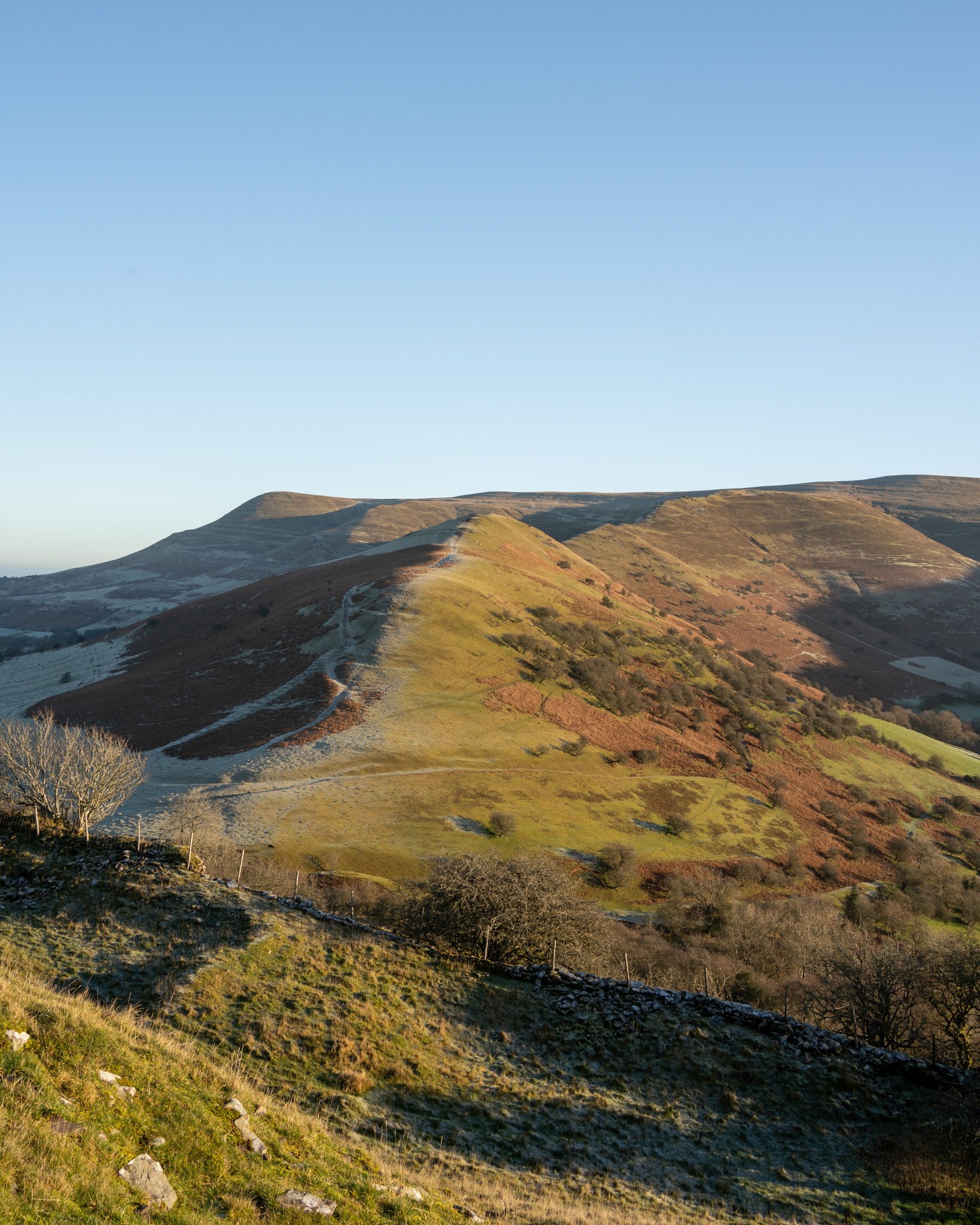
The Dragons Back
From the castle drop down north-easterly slope to the saddle over a stile, and begin ascending up the dragons back. The path is pretty evident and follows the spine of the ridge as it undulates up towards the black mountains. The route is very wide, easy underfoot, and not at all technical so you need not worry about falling of the so called ‘ridge’.

The ridge is split into several distinct sections with steep grassy inclines broken up by sections of flat terrain, giving you a chance to stop for a well earned rest while taking in what will hopefully be some fine views, down the Rhiangoll Valley, over the Wye Valley and back towards the central Brecon beacons.
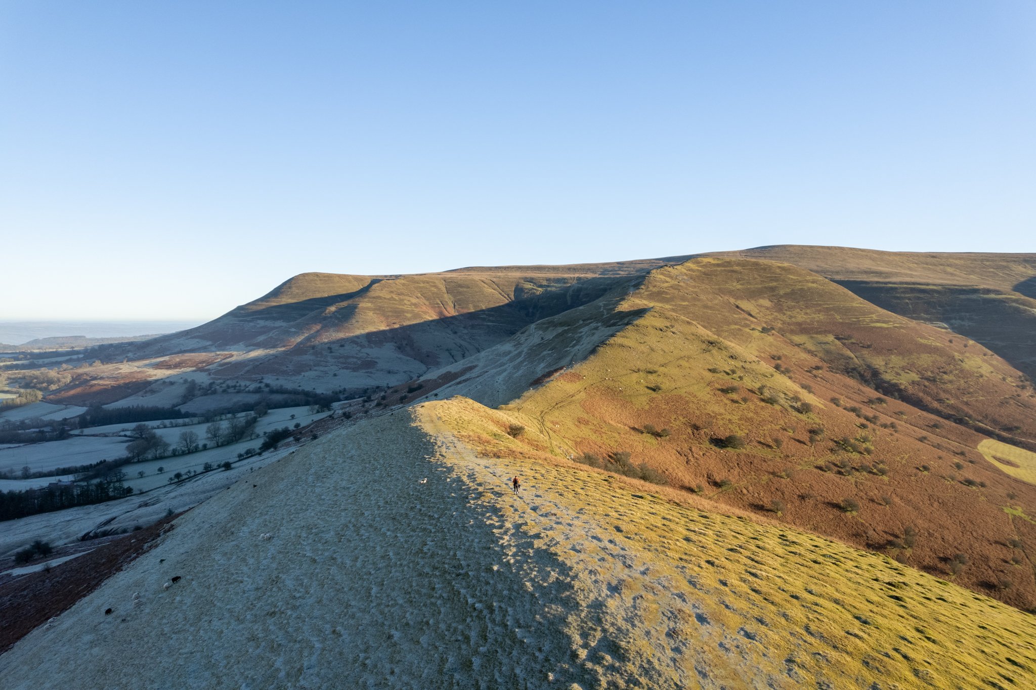

Pen-y-fan will slowly reveal itself from behind Mynydd Troed as you begin to climb the dragons back
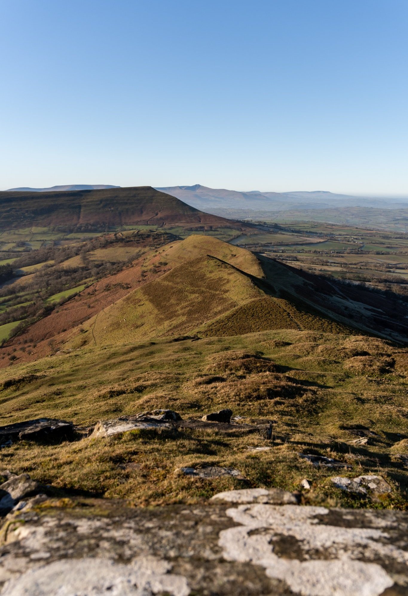
Pen y Manllwyn to Waun Fach
A pointy stone cairn will mark the end of the Dragons back and bring you onto a flat grassy plateau. From here begin the last steep climb up to the summit of of Pen y Manllwyn.

Once you reach the summit you’ll find yourself on another wide flat plateau with views now extending north down the black mountains towards Hay on Wye. Turn right and follow the wide well maintained path as it climbs gently towards the summit of Waun Fach.
As the valley drops away to your right hand side, you will have sensation views over Mynyedd Troed towards the central and Western Beacons. With the Pen-y-fan massif being clearly evident in the distance.

Looking back from Waun fach towards Pen y Manllwyn the Wye Valley

The path from Pen y Manllwyn to Waun Fach
Waun Fach Summit
The summit of Waun Fach is far less dramatic and somewhat bland in comparison to other peaks in the Brecon beacons. In fact I actually walked right past it before realising there was nothing higher around me and I was on the summit.
The trig point is a choad of a stone which sits on top of a very broad flat plateau. Considering it sits at a height of 811m, it is rather underwhelming for the second highest mountain in the Brecon Beacons and southern Britain.

An aerial view of the summit of Waun fach
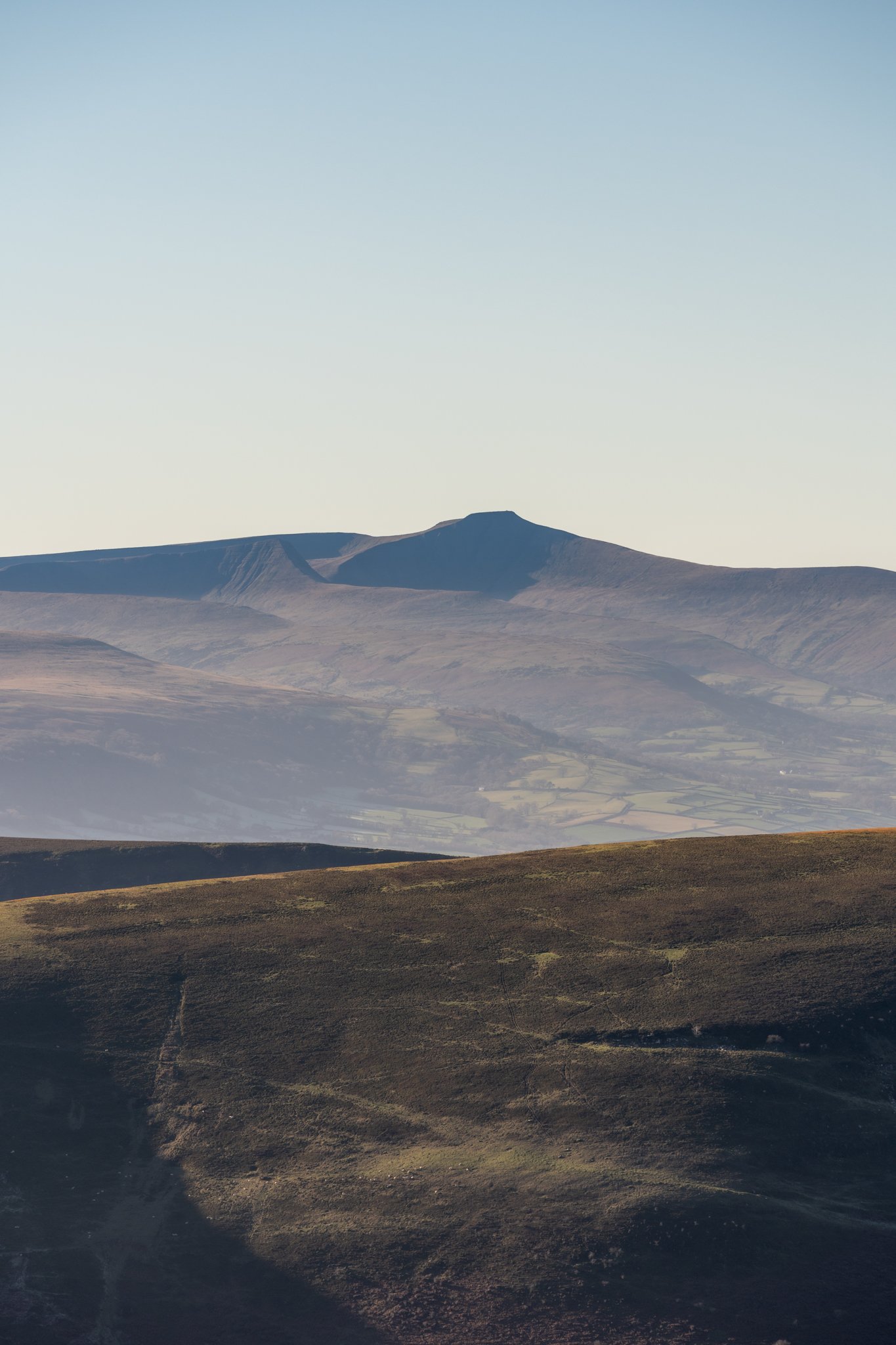
However hat the summit lacks in excitement, and grandeur it certainly makes up for in views, offering tremendous 360 panoramic views over the counties of Powys, Monmouthshire, and Herefordshire. You will be able to spot the wizards hat shaped mountain which is the Sugarloaf.
One benefit of having small flat stone as a trig point is actually makes for a lovely seat to sit and eat your lunch


The rather nonchalant trig point with the central beacons in the distance
The descent past Pen Trumau
From the summit follow the wide path that leads back towards the central beacons & the A479. The path, which is very easy to follow, gently meanders down the mountain until it reaches the lower summit known as Pen Trumau.
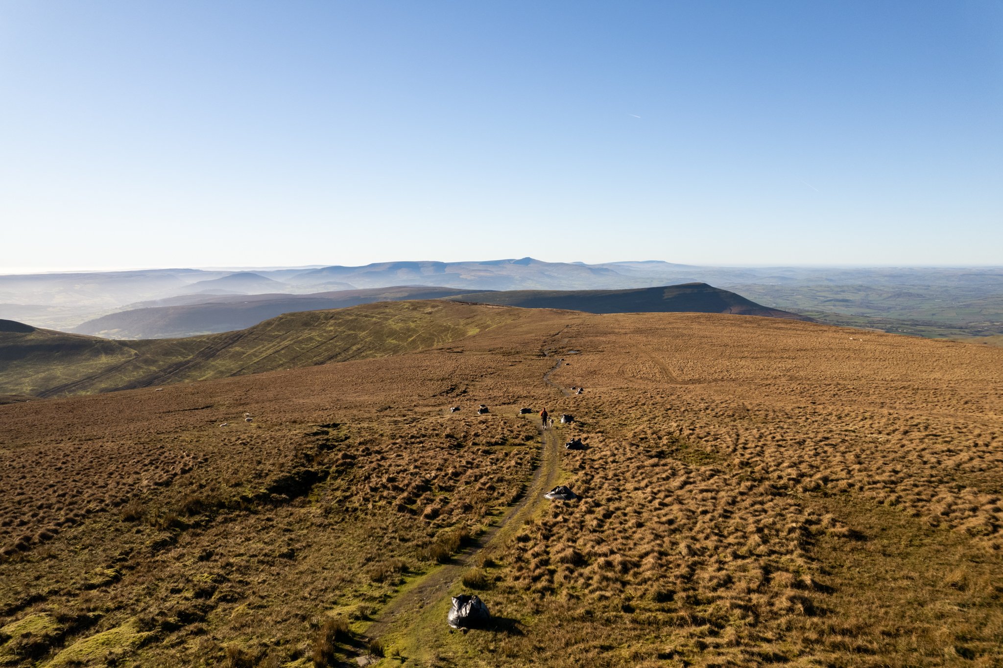
The path from Waun Fach down to Pen Trumau
To the right of the path will be a huge patch of black scarred earth, which is actually peat. This was uncovered after a major fire destroyed the layer of top soil & vegetation back in 1976.
Exposed peat is a huge emitter of Carbon dioxide into the atmosphere, so in a bid to help limit its release and heal the mountains great black wound, the national trust have started a project to try and regrow the top layer of vegetation.

The view towards Sugarloaf from Pen Trumau
From Pen Trumau, the official trail bears left and drops down to a stone cairn on a saddle which connect several routes, from hear turn right and follow the path that cuts down the open moorland, sticking left to link up with a narrower rocky path (with two wheel tracks) which drops down mountain side.

The route down from Pen Trumau

The path down from the saddle
You can also do what I did and just B-line it from Pen Trumau straight down the grassy moorland to the path which skirts around the hillside.
Once the central Brecon beacons drop out of view, the path becomes rather muddy and uninspiring. Pass through a metal gate on your left hand side which takes you between two farmers fields, before descending through a rather muddy lane lined by trees, which has evidently become a channel for excess water to flow down.

The path down the side of the mountain

Once you hit a road, turn right then fork left and follow it for half a mile past trans Wales trails riding centre, until you reach a sharp left bend with a muddy lane in front of you. Head down the lane, cross the stream and follow the path for just under 1km until you get back to the start point.

Head straight down the lane directly in front of you
My thoughts on the walk
Overall I was mightily impressed by this varied route. Having never properly hiked in the eastern Brecon beacons before I was taken back by the stunning panoramic views which the trail offered and the varied terrain which you pass.
Not only do you get treated to magnificent views on route but you will notice the trail is delightfully quieter than other peaks in the Brecon beacons. I hiked this trail on a gloriously sunny Monday in January and only passed 7 other walkers. Later that afternoon I hiked Pen-y-fan for sunset and passed over 10 times that number.
I can imagine that this trail may get busy on weekends in the summer months and as the car park isn’t the largest (it can fit around 20 cars) I’d recommend arriving early to secure a space.
Although the route is steep in sections its not at all technical and the paths were wide and very easy to follow. The ascent up the dragons back is the toughest part of the hike but also the most enjoyable, especially during the flat sections when you can stop to admire the ever improving view towards the central Beacons directly behind you.
The summit is very underwhelming but dont let that put you off, its a fantastic hike which can be tackled by even the most modest of walkers.

Help support my website
So there we have it, my hike guide to Waun Fach via the Dragons back. Did you find the blog useful and will you be wanting to tackle this hike in the future? Let me know your thoughts in the comments below.
I created and run this website in order to help inform, amaze, inspire people (for free) to get outside and explore the adventurous side of the UK.
Although I do run some google ads, I have limited them in order to make your experience on this website far more enjoyable.
If you’d like to support this website, you can use the affiliate links below to book your accommodation or transport. These come at no extra cost to you, but help keep this site running.
Book your vehicle using Discover Cars
Book your accommodation using Booking.com and Sykes Cottages
If you are feeling generous you can also Buy me a Coffee to say thank you, and give me a follow on social media.
You can find more Welsh hiking inspiration in the following blogs
For more hiking inspiration check out my other guides to the Brecon Beacons below.
Central Brecon Beacons
Western Brecon Beacons
Waterfall Country
Eastern Brecon Beacons

Find me on Instagram


