
the Pen Y Fan Six Challenge: A complete guide
If you’ve ever completed the Snowdon six challenge then you’ll know it’s a real slog, three ascents of Yr Wyddfa and 2.8 km of vertical gain aren’t exactly a relaxing day out. After ticking that off my list I decided to invent its Bannau Brycheiniog counterpart: the Pen‑y‑Fan Six.
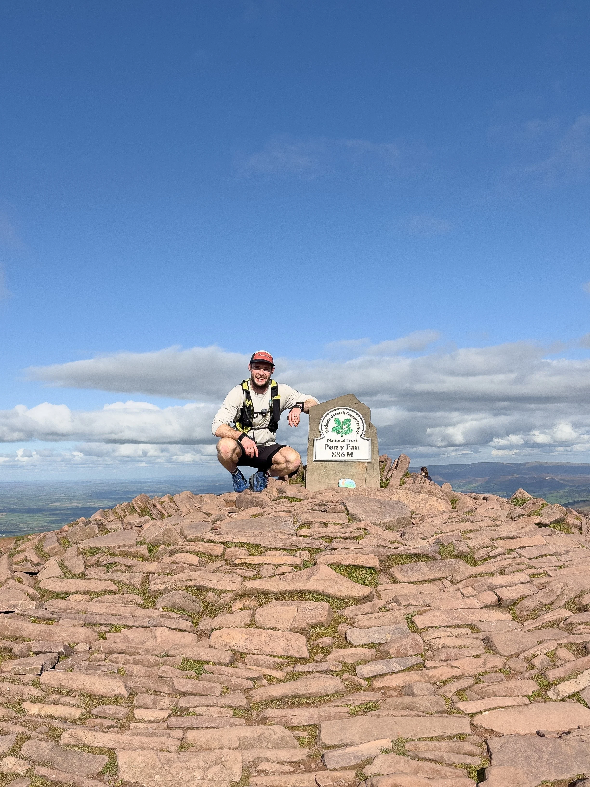
Pen y Fan is the highest point in the Brecon Beacons at 886 m and there six different trails (or three circuits) that lead to the summit.
The idea behind the Pen‑y‑Fan Six is simple: hike up and down the mountain three times in one day, using each of the six main paths as quickly as you can.
It’s not quite as long or steep as the Snowdon Six challenge or Welsh 3000s but it’s still a formidable day out.
You will endure highs and lows but providing you have a good level of hiking fitness and have good weather conditions, the challenge will live long in the memory. Also think about the strava kudos alongside how good that pint will taste after…
What is the PEn y Fan Six Challenge?
The Pen y Fan six challenge involves summitting the mountain three times, via the six main paths as quickly as possible.
The challenging route is 32km in length and involves nearly 1,900m of elevation gain and connects connects the three different horseshoes,
A470 Horseshoe (Storey arms and Pont ar Daf routes from the west)
Cwm Llwch Horseshoe (from the north)
Pen-y-Fan Horseshoe ( from the south)
Depending on your fitness levels the challenged can be hiked or run, with the goal to complete it in under 12 hours. The clock starts when you leave the car park for your first ascent and finishes when you get back.
Pen y Fan Six Challenge Details
Difficulty: Very Hard
Distance: 32km
Elevation Gain: 1,860m
Estimated Time: 5-12 hours
In what order do you complete the challenge?
The Pen y Fan six challenge can be started from one of five different car parks at the base of the mountain and done in a variety of ways.
Of all the ways to complete this challenge, I would recommend parking at Cwm Gwdi National Trust car park and completing the following route;
Ascent 1: Cwm Llwch Valley
Descent 1: Horseshoe western ridge
Ascent 2: The Gap and Jacobs ladder (Pen y Fan horseshoe)
Descent 2: Storey Arms via Corn Du
Ascent 3: The motorway from Pont Ar Daf
Descent 3: Cefn Cwm Llwch ridge to Cwm Gwdi
I recommend this route for several reasons. Firstly, you can start the challenge with the 2.3km of road which connects Cwm Gwdi with Nant Cwm Llwch. In addition, the Cwm Llwch valley ascent has the most elevation gain of the six main routes , so it is best to do complete both of these first while you are fresh and enthusiastic.
The western ridge of the horseshoe is nice and runnable, making it more enjoyable to descend than ascend. Also ascending via the Gap will give you the option to summit Cribyn when you are over half way in.
Finally the motorway from Pont ar Daf is the shortest and easiest route to the summit, so is best to leave this to last when you might be questioning your life decisions.
The best route for those using Public Transprt
If you are completing this challenge using public transport then this would be the best route;
Ascent 1: Storey Arms via Corn Du or the motorway from Pont ar Daf
Descent 1: Cefn Cwm Llwch ridge to Cwm Gwdi
Ascent 2: Cwm Llwch Valley
Descent 2: Horseshoe western ridge
Ascent 3: The Gap and Jacobs ladder (Pen y Fan horseshoe)
Descent 3: The motorway from Pont Ar Daf or Storey Arms via Corn Du

Where to park for the Pen y Fan six challenge?
You can start this challenge at one of the five main car parks located at the base of Pen y Fan.
For the reasons stated above I recommend sparking and starting at Cwm Gwdi National Trust (strangely this isn’t listed on Google).
It fills up quickly on weekends so arrive early or go in the afternoon. The roads to the car park are also single track and very narrow so take care driving them. If that is full you can park at the nearby Nant Cwm Llwch Car Park.
If you are going to complete the challenge using public transport then you can start the challenge at either Pont ar Daf Car Park or the Storey Arms.
Where does the PEn y Fan Six challenge start and end?
The challenge starts and finishes at the car park you decide to begin your first ascent from.
If you decided to start from Cwm Gwdi, you would start the clock when you leave car park, and stop it when you get back. it would be the same if you started at Pont ar Daf, Storey Arms, or Nant Cwm Llwch.
If you are deciding to park at the Horseshoe car park in the Taf Fechan forest, then the start and end point will be the fork in the path several hundred meters up the road (Image below, W3W: humidity.inhabited.tortoises).
This is because the horseshoe car park is the only one of the five car parks which the Pen y Fan Six route does not actually pass through. So for the purpose of fairness, it makes the route the same no matter where you start.
The image below is also where you make the turn around point for the horseshoe ascent and descent. You will come down the concrete road from the reservoir and go back up the gravel bridleway known as the gap (or vice versa).
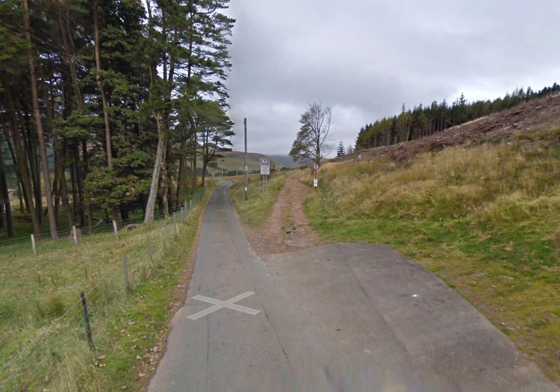
The turn around point for the horseshoe leg of the challenge (or the start and end point if parking here)
Logisitics of the Pen y Fan six challenge
One of the major benefits of the Pen y Fan Six challenge is you only need a single vehicle or public transport to complete it. Also If you aren’t feeling up to the three ascents and descents, you can always call it day after your second (or even first) ascent.
This means it is logistically much easier than both the Snowdon Six challenge or Welsh 3000s and you can easily do it alone.
Unless you use a filtration device then there isn’t any place to refill water on route.
There are food vans at both the Storey Arms and Pont ar Daf car parks which will be selling hot drinks, snacks, and some food but you wont be able to refill water at them. Whats more I am unsure if they are open 7 days a week and year round, so I would not rely on them.
I would recommend stashing some supplies at Pont ar Daf car park (or near the Storey Arms) to save on pack weight and to avoid carrying excess amounts of liquid.
I recommend these car parks as they are the easiest to access (you might even drive past them on the way to Cwm Gwdi). If you are doing the route I have outlined you will pass them when you are around 23 -24km into the challenge, just before you final ascent.
For my attempt, I left 1.5 litres of water, a red bull, chocolate, and a sandwich in a carrier bag at Pont ar Daf. Once I refuelled and topped up my water, I was able to dispose of my rubbish in the bins provided.
There aren’t bins at Cwm Gwdi, Cwm Llwch, or the Horseshoe car park, so if you choose to stash drop supplies here, you will either have to carry anything you have stashed up the mountain, or go back to collect it.
It is also worth noting that the only toilets on this challenge are located in the Pont ar Daf car park.

Pen Y fan six FAQ’s
-
Despite being shorter than the Snowdon Six, this is still a very demanding outing. The full loop is roughly 32 km with about 1 ,860 m of ascent. Essentially you are completing 2/3rds of marathon by repeatedly climbing and descending the highest peak in southern Britain. The repeated ascents test your legs and your resolve. While you don’t need to be a fell runner, you should have a solid aerobic base, strong mental resilience and experience of long mountain days
-
This challenge is ideal for hikers looking to push themselves beyond a regular day walk.
It’s a great choice for anyone wanting a unique way to experience Pen y Fan and its six approaches.
It also provides a gauge of your mountain fitness and serves as excellent training for bigger challenges like the Snowdon Six and Welsh 3000s and
-
No. The Pen y Fan Six is shorter and less technical than both the Snowdon 6 and Welsh 3000s. You’ll cover about 32 km with 1 ,860 m of ascent. Whereas the Welsh 3 ,000s involve around 50 km of walking and 3,600m of elevation gain and the Snowdon six involves around 40km of hiking and 2,800m of elevation gain.
Alongside being shorter and easier that its North Wales alternatives, because all six routes are on a single well‑maintained mountain, navigation and logistics are much simpler. In additon there are no technical or exposed section son the route, making it much safer.
-
That will depend on
Your current fitness levels
The weather conditions
Time of year you are completing it
Whether you choose to walk, hike , r run section of it.
It took me just over 5 hours, of which I was moving for 4:37.
I jogged the flat and slight uphills, ran the downhills, and speed hiked the steep uphill sections. I took 5-15 minute breaks at every summit to admire the views, refuel and capture content. I also had a 15 minute stop before my final ascent to resupply and refuel.
I estimate it should take a moderately fit walker between 8-12 hours.
I have set 12 hours as the bench mark as I want the challenge to be achievable for the everyday hiker.
To complete it under 10 hours you would have to walk at 3.2kmph for 10 hours.

Fuelling & Hydration Tips
The Pen y fan six is effectively two challenges, a hiking one and a fuelling one.
The truth is hydration and nutrition is integral to completing this challenge and shouldn’t be underestimated. Your body is capable of more than you think if you feed it properly. How much fluid and what you will need to eat while undertaking the challenge will depend on a few different factors
The weather
Your physiology and size
How much effort you are putting into each ascent
How much you drink before you start
To make sure you start and stay hydrated, I recommend consuming between 500ml and 1 litre of fluid before you start alongside carrying and consuming between 500ml and 1 litre of fluid per ascent.
I would also consider using some form of electrolytes to replenish what you’ve lost alongside preventing over hydration and cramp. I’d recommend using Precision Hydration electrolyte tablets which you can just drop into a bottle of water and are easy to carry.
Its also important to start the challenge fuelled and keep topping up the energy levels when you are doing the challenge
Although you may not be running it, I would class the Pen y fan Six challenge as an endurance style event which will last anywhere between 5-12 hours.
This article from runners world stated “Research findings support the consumption of 1 gram per kilogram of bodyweight per hour for men, and 0.8 grams per kilogram of bodyweight per hour for women during ultra events”
As an 80kg male I was aiming for around 60-80g of carbs and around 250-300 calories per hour.
What you eat is down to personal preference and should be food that you have tried and tested on hikes before. Don’t rely solely on sugary snacks as your body will just end up crashing. In addition you may end up with stomach issues.
The key for me was eating something every hour, even if didn’t feel like it. This was to keep my energy levels high and prevent hitting the dreaded wall or ‘bonking’.
What i ate and drank for my 5 hour effort
I drank 500ml of pre-mixed electrolytes (I use Precision Hydration 1500 as they are the strongest available) and a 500ml Oasis summer fruits in the car park before I set off.
I then carried 1.5 litres of fluid (80g liquid carbs with two PH 1500 electrolyte tabs), which lasted around 20km.
As I had stash dropped supplies at Pont ar Daf, I was then able to rehydrate and top up my fluids before the last ascent.
To keep my energy levels topped up, I aimed to eat around 50-70g of carbs an hour. This was spread between liquids, gels, and solids.
SIS Beta fuel powder - 80g
SIS Beta Fuel Gel - 40g
2 Cliff bars - 80g
3 Ferrero Roche’s (Cheeky Tesco meal deal)- 45g carbs
Banana - 22g carbs
Oasis Summer Fruits 500ml - 20g carbs
Peanut butter M&M’s and Sour Patch kids - Unlimited energy

-
Plan and understand the Route: Make sure you know all the key Information (Distance, Elevation Gain, Route Profile, Terrain, Technical Aspects, Where to park) and that the hike is suitable for you and any other members of your group
Check the weather: Always check the weather forecast for the specific peaks and mountain ranges you are planning on hiking. I use MWIS and Met Office and focus on the four following factors; Feels like temperature, Chance of Rain, Visibility, and Wind speed
Download the route & Use proper hiking app: I use and recommend OS Maps and have the route downloaded for offline use
Let someone know your plans: What route or mountains you are hiking, where you are parking, and roughly how long the hike will take
Give yourself more time than you need
Group Up: If possible, hike with others or consider hiring a local guide for extra safety
Know Your Limits: If the hike is too difficult, technical, you aren’t feeling up for it, or if the weather changes don’t be afraid to stop or change your plans.
Wear and carry the correct kit: see below
-
This will be dependant on the weather conditions and season you are hiking in, alongside your own physiology.
Always check the weather forecast for mountain you are hiking. I would recommend using the on the Met Office website and MWIS playing close attention to the following things:
Feels like temperature at the summit
Chance of Rain
Visibility/ Chance of cloud free peaks
Wind speed
These four things will dictate what you wear and carry. While it is only a short hike, it will be colder and windier at the top than at the car park, so it’s better to carry extra layers/waterproofs just incase.
Essentials
Grippy and stable footwear:
Layering system: 2-4 layers for your top half and 1-2 for the bottom
Base layer (T-shirt)
Mid layer (hoodie)
Outer shell (Wind breaker or waterproof)
A Hiking/ Navigation app with the route downloaded for offline use: I use and recommend OS Maps
Other things
Fluid + snacks
Backpack to carry your spare layers, water, and snacks
Gloves, beanie, and face buff
Head torch (If heading up at sunrise or sunset)
Portable Power bank and charging cable
Hiking Poles
-
Base layers
Smartwool Active hoodie - My go for spring, summer, and autumn hiking.
Smartwool Intraknit Thermal Merino Base Layer 1/4 Zip - My choice in winter and colder weather.
Mid LayersColumbia Triple Canyon Hooded Fleece Jacket- Lightweight, warm, comfy, and stretchy. Everything you need from a mid-layer. It also has elasticated thumb loops, a close-fitting hood, and three zip pockets.
Rab Men's Microlight Alpine Down Jacket - Essential for the colder months, wildcamping, and when you are soaking in the views up on the summit.
Outer shell
Columbia Ampli-Dry III Jacket - Waterproof, lightweight, functional, and packs down small. It also has breathable stretch shell fabric with underarm zipped ventilation.
Lower Half
Footwear
Columbia Montrail Trinity Ag II - The comfiest summer hiking and trail running shoes I have ever worn.
Adidas Terrex Free Hiker 2 GTX - My go to for the wetter months of the year
Columbia Men's Facet 75 Equinox – My go to in Winter, incredibly comfortable, waterproof and warm
Socks
Darn Tough Vermont Van Grizzle Boot socks – My winter sock of choice
Backpacks

Summary and final pieces of advice
Save it for a good day: If you can, be flexible with dates so you can take this on in the best conditions possible. Poor conditions can be both energy and morale sapping alongside dangerous. One non-negotiable for me would be visibility, It impacts both navigation and views which has a huge impact on motivation.
Make sure you are fit enough: Rack up the mountain miles. You should be comfortable hiking in the mountains on long distance hikes (6+ hours) which have significant amounts of elevation gain (1,000 -1,500m).
Have the route downloaded offline on a proper hiking app: I’d recommend OS Maps premium subscription
Have the correct gear – Essentials include appropriate footwear, waterproof jacket, backpack, extra layers, and a power bank. I recommend wearing trail running shoes and using hiking poles as they will make a world of difference going both up and down.
Take it slowly: It’s over 3/4 of a marathon so don’t go blazing up on your first ascent.
Hike with people on the same level as you: If you’re doing it with a friend or group, make sure they have a similar fitness level, and you all understand what time you aim to complete it in. If one person is significantly faster or slower than the other, it’s going to be frustrating for both people and will take the enjoyment out of the challenge.
Eat little and often: This challenge is an eating one as much as its hiking one. Keeping you energy levels high will make a huge difference to morale and success of the challenge. Eat something before you start, after each descent, alongside eating snacks every 60 minutes.
Enjoy the views from the summit: Make sure you take 10-20 minutes to eat some food and enjoy the views when you are up there.
Stay on top of your hydration: Don’t start dehydrated and look to carry between 0.5-1.5 litres of fluid per ascent. Consume plenty of fluid after each descent and consider using electrolytes and sports drinks to replace salts and keep energy levels up.
Break the challenge down: The scale of the challenge can be overwhelming. Break the hike down into three ascents, give yourself realistic time targets for each, This gives you something to aim for and makes the hike seem more manageable.
Know your limits: Park your ego and don’t be afraid to pull the plug if things aren’t going your way. The mountain will always be there and you don’t want to end up hurting yourself.

Pen y Fan FAQ’s
-
Pen y Fan stands at 886 m (2,907 ft), and is the highest point in Bannau Brycheiniog (Brecon Beacons) National Park and South Wales
-
In my opinion it would be the Cwm Llwch Horseshoe. Its incredibly scenic, passes a variety of landscapes and is much quieter than other routes.
If you are looking for the best out and back route then that would be Pen y Fan from Cwm Gwdi via Cefn Cwm Llwch.
If you want to summit multiple peaks (such as Cribyn and Fan y big) then I would recommend the Pen y Fan Horseshoe or the Circuit of the Central Beacons.
-
That would be Pen y Fan from Pont ar Daf.
It is the shortest route with the least elevation gain. It is 3,2km one way, climbs steadily to the summit via well built path and involves 454 m of elation gain.
Active children can manage it and should take between 45-90 minutes one way.
-
The hardest direct route to the summit of Pen y Fan is from Nant Cwm Llwch, as this has the most elevation gain.
However, the Pen y Fan horseshoe is considered more challenging (14km / 800m of elevation) as it involves summiting other peaks.
If you want a tough day in the hills consider hiking the Circuit of the Central Brecon Beacons (21km / 1,086m of elevation) or the Pen y Fan Six Ways ( 32km, 1,800m Elevation)
-
There are National Trust car parks at Pont ar Daf Car Park and Storey Arms (west), Cwm Gwdi National Trust or Nant Cwm Llwch Car Park (noth); You can also park at the Neuadd car Park in the Taf Fechan Forest for the horseshoe.
-
Allow 3–8 hours, depending on the route and your fitness. The gentle path from Storey Arms or Pont ar Daf is 4 mi/6.5 km involves 454m of elevation gain and takes 3–4 hours; longer circuits via Cwm Llwch or the Horseshoe Ridge take 5–8 hours
-
You can hike Pen y Fan alone. The peak is so busy there will always be another person hiking it. The most popular route is from Pont ar Daf.
-
There are no toilets on the mountain or summit; the only toilets are at Pont‑ar‑Daf car park.
-
Yes, dogs are welcome but must be on a lead and under control.
-
Yes. Pen y Fan is significantly easier than hiking Yr Wyddfa (Snowdon). The routes are musch shorter, less rugged and involve less elevation gain.
-
In dry conditions you can hike up Pen y Fan in trainers, especially if you are hiking from Pont ar Daf However in the wetter conditions and winter I would recommend hiking shoes/boots or trail runners with better grip.
-
Brecon is the nearest town (about six miles north of the main trailheads), offering shops, cafés and accommodation.

Help support my website
There we go, a guide to the Pen y Fan Six challenge. Let me know in the comments if you want to give it a go, if you have any questions and if have completed it, what your time was.
I created and run this website in order to help inform, amaze, inspire people (for free) to get outside and explore the adventurous side of the UK.
Although I do run some google ads, I have limited them in order to make your experience on this website far more enjoyable.
If you’d like to support this website, you can use the affiliate links below to book your accommodation or transport. These come at no extra cost to you, but help keep this site running.
Book your vehicle using Discover Cars
Book your accommodation using Booking.com and Sykes Cottages
If you are feeling generous you can also Buy me a Coffee to say thank you, and give me a follow on social media.
Thank you, and if you have any questions, leave them in the comments below or drop me an email!
For more hiking inspiration check out my other guides to the Brecon Beacons below.
Central Brecon Beacons
Western Brecon Beacons
Waterfall Country
Eastern Brecon Beacons
