
Hike Guide to Pen Yr Ole Wen & The Carneddau | Snowdonia National Park

This monster 15km hike summits Pen yr Ole Wen, before looping around the Carneddau range to the second-highest peak in Wales, Carnedd Llewelyn (1,064 m).
The route offers tremendous views over the Ogwen Valley towards the iconic peaks of Tryfan and the Glyderau. The hike also involves over 3,000 ft of ascent and descent so don’t forget to pop an ibuprofen and strap up those knees.
Key Information
Hike Type: Loop
Hike Distance: 10 miles/ 16km
Hike Duration: 5-7 hours
Elevation Gain: 1,120m
Hike Difficulty: Very Hard
Mountains Summited: Pen Yr Ole Wen (978m), Carnedd Daffyd (1,044m), Carnedd Llewellyn (1,064m), Pen yr Helgi Du (833m)
Parking: Ogwen Valley
What Three Words location of start point: invented.straws.polar
Where to park
I would recommend trying to park in the designated free parking laybys in front of Gwern Gof Uchaf campsite on the side of the A5 in the Ogwen valley.
These can fill up quite quickly so you may have to drive further down the A5 to find a space. As this hike is a loop it doesn’t matter too much where on the A5 you park. It will just determine if you start or end your hike with a walk alongside the A5.
The nearest toilets are available at the Ogwen partnership centre, so I’d quickly stop by them first before parking.
The Route
From the A5, cross the river denau follow the path past Glan Dena cottage at the eastern end of Llyn Ogwen and begin climbing up the right hand side of the river Lloer.
As you you weave your way up the mounatin you will pass over the river and work your way up towards wooden stile on a stone wall.
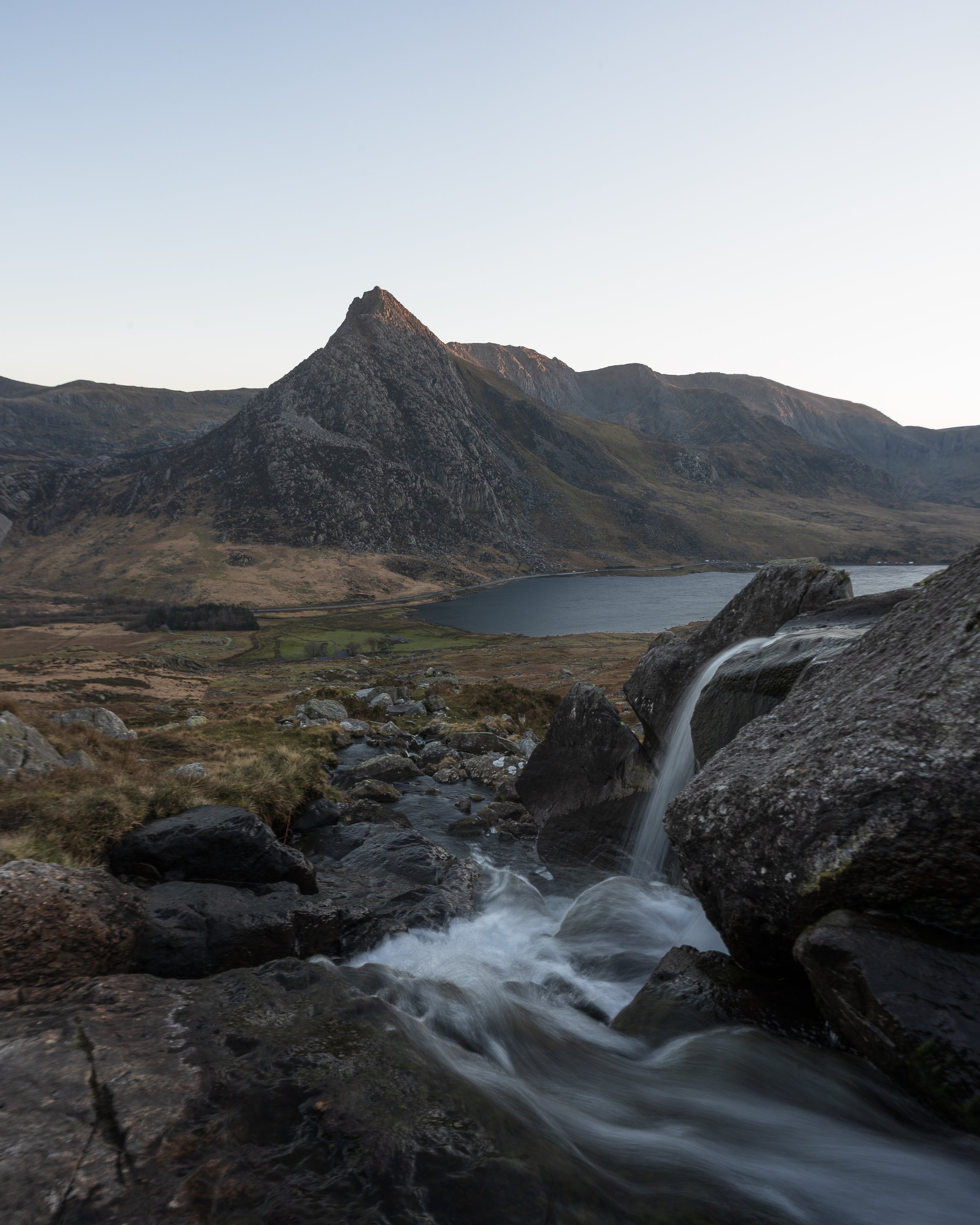
The climb will offer great views (and multiple photo opportunities) back down the Ogwen valley towards Tryfan and if you’re lucky you will spot the wild horses of the Carneddau.
Onceover the stone wall continue to follow the river as it bends up and around towards Ffynnon Lloer.
The path will then briefly level out before beginning to climb steeply up the south east face Pen-yr-Ole Wen.
Within the earlier sections of this climb there are some minor elements of scrambling which aren’t too technical or exposed. Once these are out of the way the path becomes clear and obvious as it climbs relatively steeply up to the summit.
Standing at the same height as England's highest peak, Scafell Pike the 978 m summit of Pen yr Ole Wen is the seventh highest mountain in Snowdonia and Wales.
The pyramidal summit is the most southerly of the Carneddau range and looms large over the Ogwen valley below.
The mountains unique position means it has a sensational panoramic view back towards the Glyderau range and southern Snowdonia. Looking north over the Menai straight you will also be able to see over the majority of Anglesey.

The Glyderau from Pen yr Ole Wen
Once normal breathing has been resumed continue onwards along the ridgeline towards Carnedd Daffyd.
The one mile path is very straight forward and relatively easy underfoot, dropping slightly before gently rising up to the summit of Wales third highest mountain.
Like most of the peaks in the southern Carneddau, the flat, boulder-strewn summit summit is rather unassuming and resembles more of a plateau,

Looking east towards Carnedd Daffyd and Llewellyn from Pen yr Ole Wen

Tryfan from Carnedd Daffyd
From Carnedd Daffyd continue to follow the path for 3km alongside the ridgeline north eastwards towards Carnedd Llewelyn.
Once again the path is very wide and obvious to follow but can be quite rocky underfoot.
Before you make the final short but steep 600m climb to the summit of Carnedd Llewellyn, you will have option to skirt around its base to visit the neighbouring summit of Yr Elen.
The 962 m peak is the ninth highest in Wales and reaching it involves adding and extra 2.5km and 150m of elevation gain onto your route.
Although the views from the summit are impressive, its a detour I wouldn’t bother making unless you are desperate to ‘peak bag’ and to tick it off your list.

The summit of Yr Elen

Looking south from the summit of Yr Elen
Translated to "Llywelyn's cairn" in Welsh, Carnedd Llewelyn Iis the highest point of the Carneddau and the second highest peak in Wales,
It is widely believed that Carnedd Llewelyn and the neighbouring Carnedd Dafydd are named after Llywelyn ap Gruffudd and his brother Dafydd ap Gruffudd, the last independent princes of Wales.
The summit again is wide rocky plateau marked by a small circular stone shelter.


Looking North east towards Carnedd Gwenllian
From Carnedd Llewellyn follow the ridge south east for one mile down towards Ffynnon Llugwy Reservoir.
After one mile you will find yourself in a saddle at a cross road of paths, from here you can make the short 600m climb whic involves 90m of elevation gain up to the 883m summit of Pen yr Helgi Du.
Alternatively you can follow the path which drops down past reservoir south into the Ogwen valley for 4km until you reach the A5.
Once at the roadside, simply follow the road back to your car.

Carnedd Llewellyn summit
HELP SUPPORT MY WEBSITE
I created and I run this website in order to help inform, amaze, inspire people (for free) to get outside and explore the adventurous side of the UK and beyond.
If you’d like to support this website, you can use the affiliate links below to book your accommodation or transport. These come at no extra cost to you, but help keep this site running.
Book your car using Discover Cars
Book your accommodation using Booking.com
If you are feeling generous you can also buy me a coffee to say thank you, and give me a follow-on social media.
Thank you, and if you have any questions, leave them in the comments below or drop me an email.
You can find more Snowdonia and North Wales inspiration in the following blogs
The must-visit photography spots in Snowdonia National Park
The best places to watch the sunrise in Snowdonia National Park
The 10 best places to watch the sunset in Snowdonia National Park & North Wales
Hike Guides
For more Welsh travel inspiration check out my in-depth guides to each of my favourite Welsh regions below.
Thanks for stumbling across my blog.
I’m Chris Knight, a freelance content creator who has a passion for hiking, photography, and seeking adventure at any opportunity.
Within my blogs you’ll find adventurous travel guides to Wales, Lake District, Scotland, Madeira, and the Dolomites.
Hopefully the pages on my site will provide you with some inspiration for your next trip.
If you’d like to support this website, you can use the affiliate links below.
FIND ME ON INSTAGRAM

Find me on Instagram


