
35 of the best hikes in the Lake District National Park - From beginner to expert
With 214 fells, 197 tarns, and thousands of miles of of paths to choose from, hiking is easily the best way to enjoy the incredible landscape that the Lake District National Park has to offer.
Unfortunately the abundance of choice can sometimes make deciding which route to pick seem slightly overwhelming.
In this blog I share 35 of my favourite hikes in the Lake District.
The list includes a huge variety of hikes across all types of terrain which encompass the best that National Park has to offer.
I have grouped the 35 hikes into five categories: very easy, easy, moderate, hard, very hard, with seven hikes in each.
This means no matter your ability or age, there is a hike in this blog for you.
The grading of the hikes is based off those with a moderate level of fitness who have done some hill walking before.
I may have played it safe with some of the hikes and overestimated their difficulty. This means that the fitter and more experienced walkers might find some of the hikes not as challenging as I have suggested.

Four tips to safely enjoy the mountains
A proper navigation App is essential
I advocate that everyone uses a proper hiking app which they understand and is available to use offline.
My app of choice would be Ordnance Survey.
The yearly subscription, which costs £28, gives you digital access to all 607 OS maps which covers the whole of Great Britain.
You can use it on any device, download routes to your phone, and even print of physical to-scale maps as a backup.
Just always make sure your maps and route is downloaded before you set off, as signal in the hills can be very patchy.
I would also recommend downloading the app Maps.Me.
This is a free offline mapping service which helps with both navigation and finding essential locations such as shops, petrol stations, and restaurants.
I use this to navigate by car when I don’t have any signal, which is a common occurrence in the mountainous areas of the UK.
As it also shows topographical features such as mountains and waterfalls alongside displaying hiking trails and contour lines, it also doubles up as a back-up hiking app to OS Maps.
Remember to always carry a power bank and cable just incase your phone does run out of battery.
Always check the weather forecast for the summits
Never assume the weather on the summits will be same as down in the valley.
Cross check and monitor the weather conditions for the summits right up until the morning of your hike. I would recommend using both the Met Office alongside MWIS- Mountain Weather Information Service.
Focus on three things: chance of precipitation, wind speed, and feels like temperature. These will give you a good idea of what the conditions will be like alongside what clothes and gear to wear.

Dress for the conditions and the time of year you are hiking in.
I always recommend a three tier layering system on top (base layer , mid-layer, and waterproof) and having/ carrying the following;
Waterproof coat
Quality walking shoes/boots
Food and water
Backpack
Extra layers - Down jacket/mid layer, hat, gloves
Head torch, power bank, and cable
Know your ability and limits
If you aren’t a competent hiker (Please don’t mistake confidence for competence), avoid hiking a route which might be too hard. If the weather conditions aren’t looking great, then consider a lower level or easier hike instead.
If you do find yourself on an mountain and the weather worsens or the route is tougher than you think, don’t be afraid to cut your hike short or turn around.
Your ego is the enemy and the mountains will always be there.
There’s no point risking injury, possibly your life, and the time and effort of mountain rescue for the sake of a hike or summit selfie.

Very Easy Walks
These walks are characterised by being low level, having minimal elevation gain, and requiring very little effort to complete.
Several of these are wheelchair and pushchair friendly, making them perfect for those with young families or if you are looking to give the legs a break from the mountains.
Friars Crag, Derwentwater
Hike type: Out and back
Hike distance: 2-5km
Elevation gain: 5-50m
Hike time: 45 minutes to 2 hours
Wheelchair Friendly: Yes
Parking: Theatre by the Lake car park
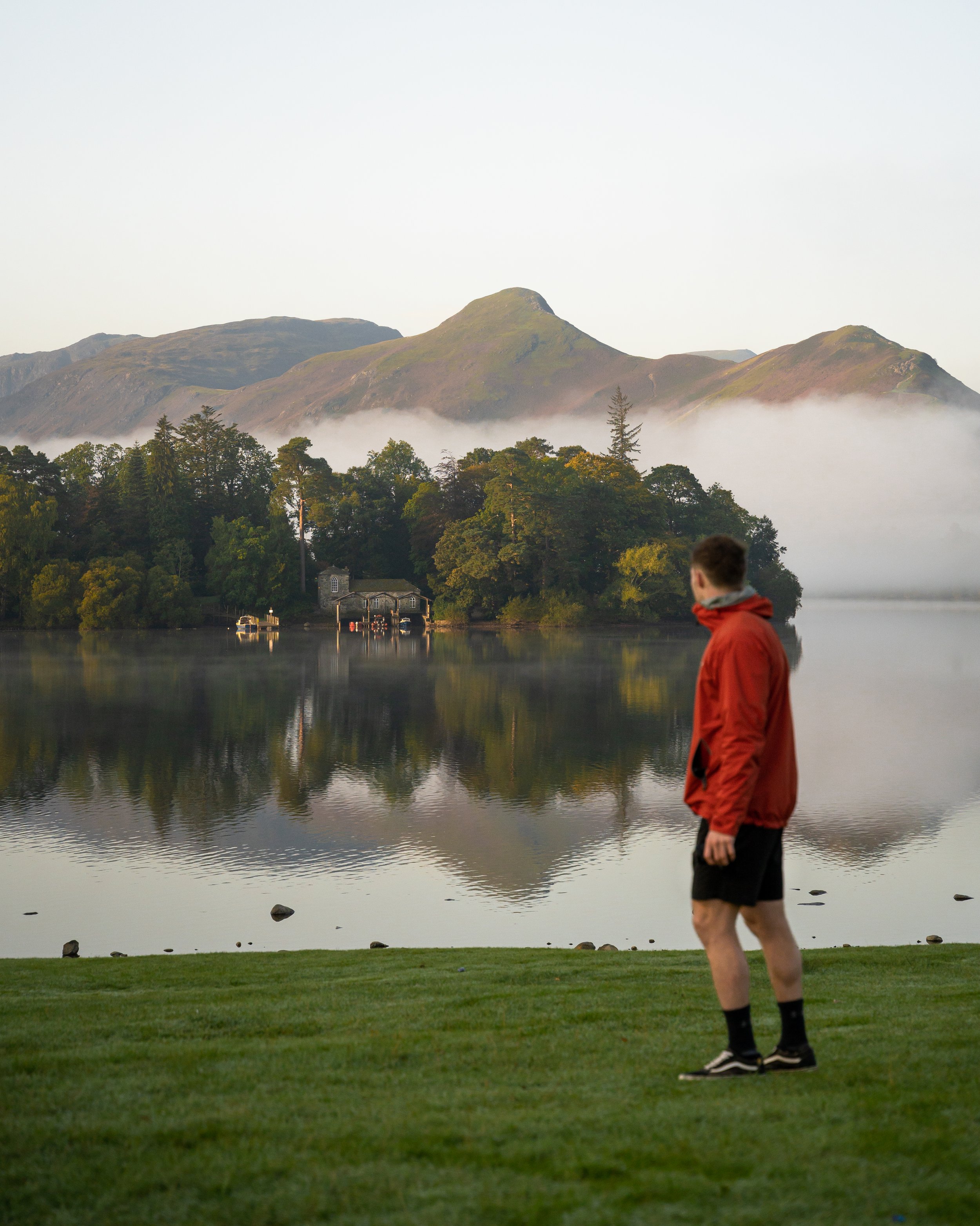
A magical short walk along the Derwentwater foreshore to one of the most accessible and beautiful viewpoints in the Lake District.
The 1km route takes you out to Friars Crag, which looks out over Derwentwater towards Cat Bells and the Jaws of Borrowdale. There’s even a bench positioned at the headland allowing you to sit and enjoy the view.
From Friars crag you can either continue for a further 1.5km around the lake’s foreshore to Calfclose Bay, or retrace your steps back to the car park.
Because of its popularity and accessibility I would recommend heading to this spot for sunrise to avoid the crowds and to get an even more magical experience.

Blea Tarn, Langdale
Hike type: Out and back
Hike distance: 2.75km
Elevation gain: 70m
Hike time: 1 hour
Wheelchair Friendly: Yes
Parking: Blea Tarn National Trust car park
Situated in a hanging valley between Little and Greater Langdale, Blea Tarn is a small but tranquil body of water surrounded by craggy fells.
The mountain lake is extremely popular with landscape photographers due to the mirror-like reflections it produces of the Langdale Pikes. It’s also a great location for stargazing and astrophotography due to its ease of access and dark sky location.
A National trust car park is situated opposite the tarn and is £3 for 2 hours or £5 for all day. Once at the car park you simply cross the road and descend the wheelchair friendly path for 250m until you reach the shoreline.
I'd recommend heading to Blea Tarn for sunrise in order to enjoy it's full beauty.


Tarn Hows, Hawkshead
Hike type: Loop
Hike distance: 3km
Elevation gain: 40m
Hike time: 1-2 hours
Wheelchair Friendly: Yes
Parking: National Trust car park
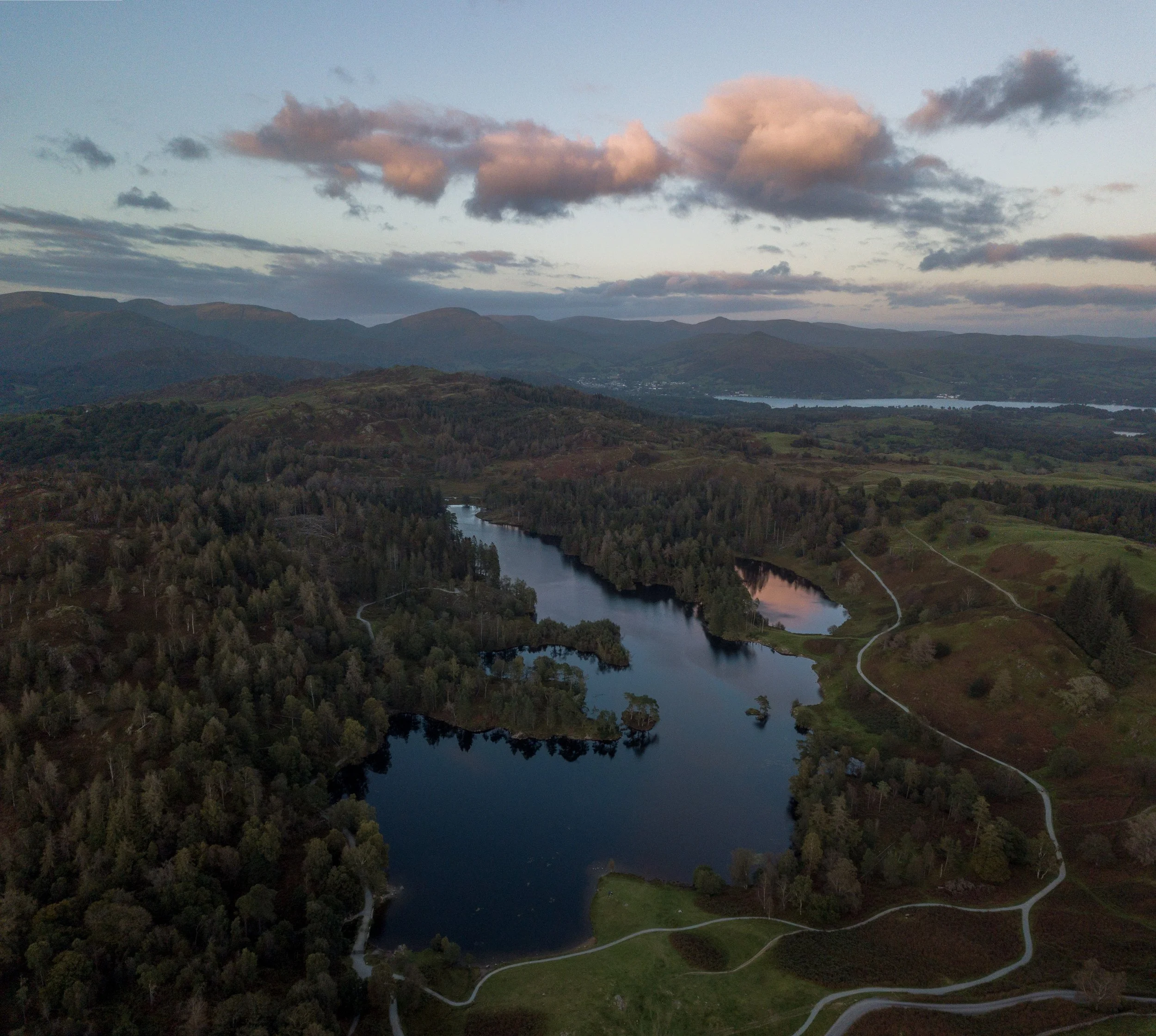
Situated in the low-level hills between villages of Coniston and Hawkshead, Tarn Hows is one of the most visited and easily accessible tarns in Lakeland.
Once owned by children’s author Beatrix Potter, The area is a series of tranquil man made lakes surrounded by beautiful countryside and a thick conifer woodland.
Encircling the Tarn is a 3km wheelchair friendly path which offers mountain views towards the Helvellyn range and the Langdale Pikes.
As it is one of the most popular spots in the Lake District, I would recommend heading here in the early morning or the late afternoon to beat the crowds.

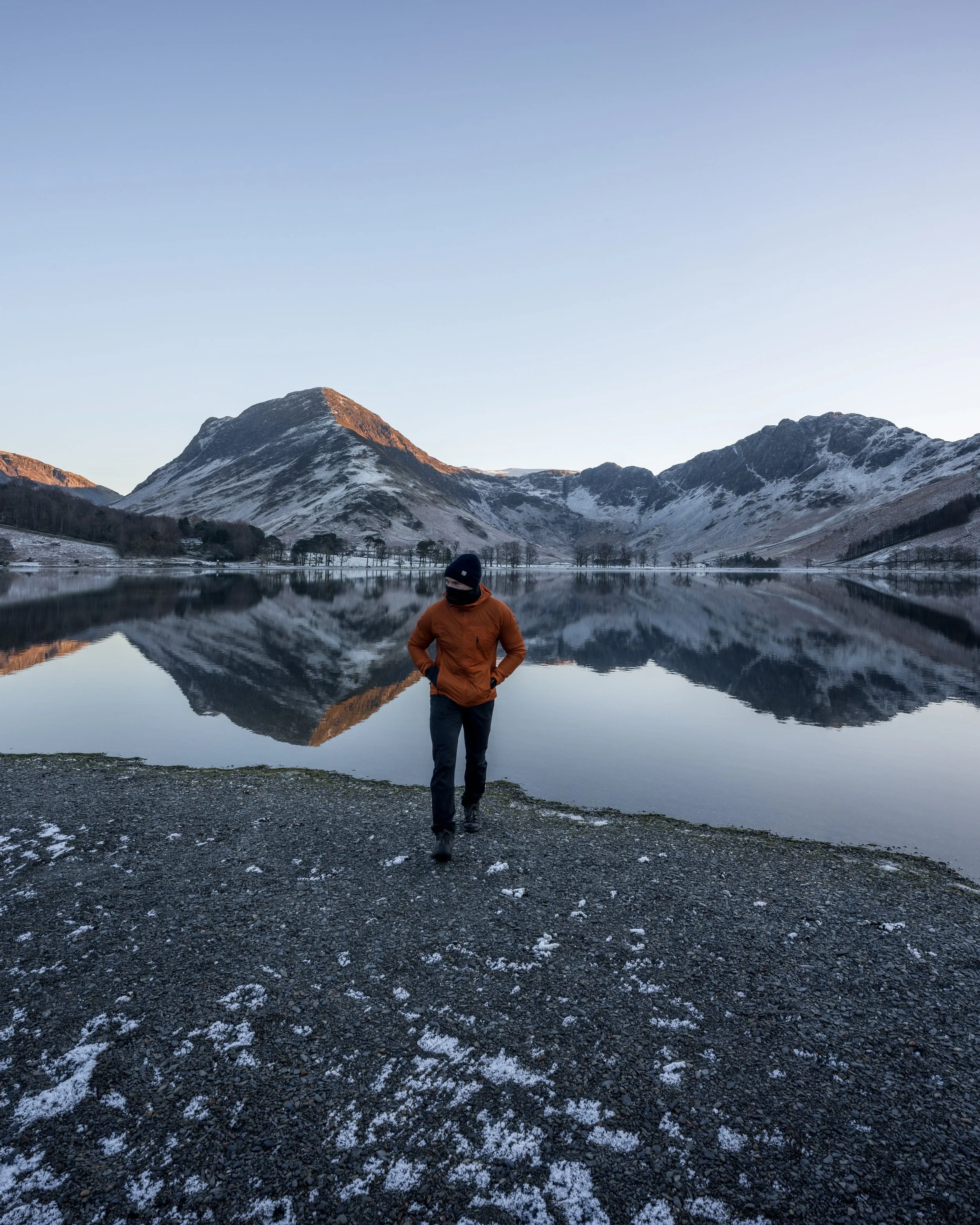
Buttermere Lake
Hike type: Loop
Hike distance: 7.4 km
Elevation gain: 96m
Hike time: 2-3 hours
Wheelchair Friendly: The northern & western shore
Parking: National Trust Buttermere
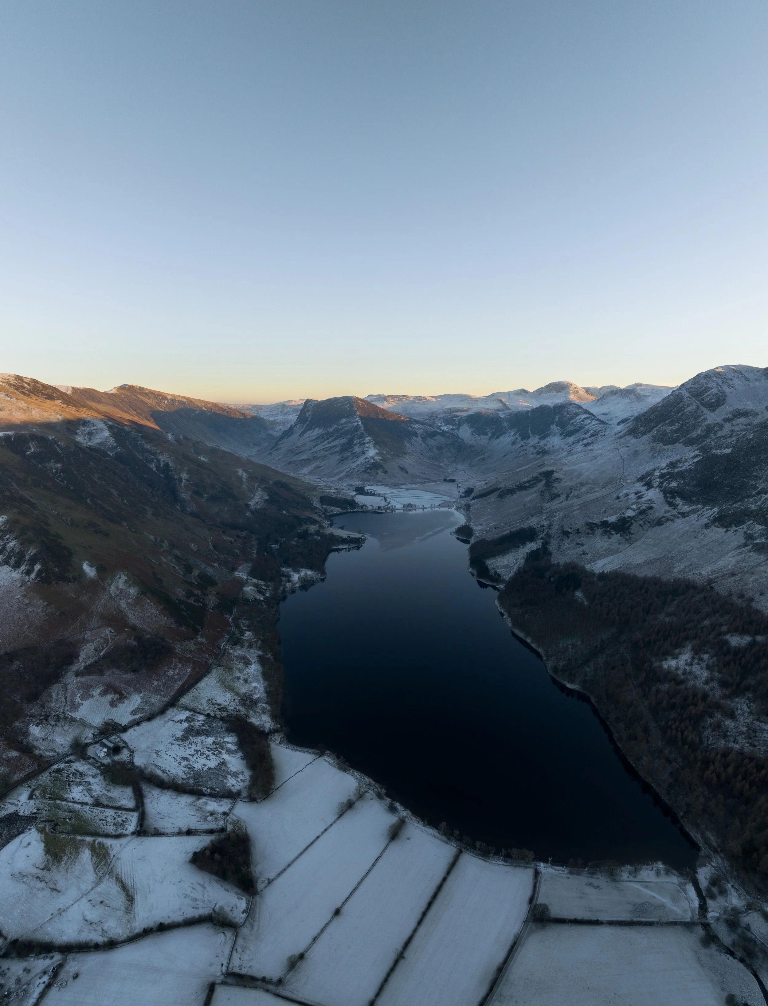
Buttermere valley and lake is consistently voted for as one of the most beautiful landscapes in both the Lake District and the UK.
The lake shoreline is lined with forests enveloped on three sides by craggy fells. On a calm day you will be treated to glorious reflections of the lofty craggy fells which encircle the lake on three sides.
This 6km hike completes a full loop of the beautiful Buttermere lake and although long, is arguably one of the most relaxing and picturesque in the Lake District. The entire trial is pretty much flat and over half of it is wheelchair friendly.
If you didn’t want to complete a full loop of the lake, you can take a short stroll out to the foreshore at the north western end of the lake.
If the weather is glorious I’d recommend packing some swimmers and a towel for a dip and calling by Croft House Farm Café for a hot drink and some food afterwards.
Latrigg Fell, Keswick
Hike type: Out and back
Hike distance: 2km
Elevation gain: 75m
Hike time: <1 hour
Wheelchair Friendly: Yes
Parking: W3W - visitor.whisker.partner
Due to its quick and easy access, Latrigg Fell is the ideal spot for sunrise or if your want mountain vistas when you are short on time or energy.
On a good day, you will have amazing views over Derwentwater and the Borrowdale valley and a full panorama of some of the highest mountains in England including Scafell Pike, Helvellyn, and the Newlands Horseshoe.
There also a appropriately placed bench at the viewpoint so you can sit and enjoy the magnificent view.
The 1km wheelchair friendly path skirts around to the right, and the more direct route leads over the top of the Latrigg Fell.


Rydal Mount and Gardens, Grasmere
Hike type: Loop
Hike distance: <1km
Hike time: <1 hour
Wheelchair Friendly: yes
Parking: Rydal Mount & Gardens
Free to enter, Rydal mount and Gardens was once home to poet William Wordsworth. It has a stunning waterfall with small viewing house which sits at its base.
Originally built in 1668, ‘The Grot’ is regarded as the oldest viewing house in the country and has a large glass panelled side which looks directly towards Rydal falls.
Parking is available on site and the you can pay to enter the building. I would also recommend taking the time to walk down and around Rydal water alongside Rydal caves too.


Aria Force, Ullswater
Hike type: Loop
Hike distance: 1.5km
Elevation gain: 70m
Hike time: < 1 hour
Wheelchair Friendly: No
Parking: Aira Force Car Park
The most popular waterfall in the Lake District for a reason.
Aria force may not be the highest, widest, or most dramatic waterfall in the Lake District, but it’s fairy tale-esqe surroundings make this beautiful waterfall a must visit.
Set within a steep gorge and enclosed by a colosseum of towering nature, the main fall cascades for 70ft from beneath a stone footbridge.
The route isn’t wheelchair friendly and does involve naviating some steps and uneven ground so many not be suitable for everyone.
The waterfall is extremely popular, with the lower car park often full before 10am. To avoid the crowds, plan to visit Aria force as early as possible, ideally around sunrise.


Easy Walks
Characterised by being short or including minimal elevation gain, these hikes are great introduction to the fells of the Lake District, offering magnificent mountain vistas with very little effort.
Although a couple of these hikes involve a steep climb, they aren’t technical and should be achievable for most people, including those with limited levels of fitness and walking experience or those with younger children.
Gummers How, Windermere
Hike type: Out and back
Hike distance: 2km
Elevation gain: 130m
Hike time: 1-2 hours
Parking: Gummers How car park
The short 2km hike up to this mini-mountain only involves 130m of elevation gain and is one of the best introductory Wainwright walks in the Lake District.
Popular with families, it has many of the characteristics of a walk in the higher Lakeland fells, with some steep but short slopes and rocks to negotiate,
The reward for making the short ascent will be stupendous panoramic views over the Lake District, looking north over Lake Windermere and south towards Morecambe Bay.
Because of its ease of access and short distance to the summit, Gummers How is a great option for both sunrise and sunset.

Photo by Jonny Gios on Unsplash
Easedale Tarn via Sourmilk Ghyll, Grasmere
Hike type: Out and back
Hike distance: 7.5km
Elevation gain: 230m
Hike time: 2-4 hours
Parking: Red Bank Road car park, Grasmere
Easedale tarn is situated in a hanging valley above Grasmere and is surrounded by an amphitheatre of craggy fells.
The well signposted route begins in the gorgeous village of Grasmere and follows a well-maintained and scenic path up to the Tarn. On route you will pass through farmland, cross several stone bridges, and walk alongside the plunging falls of Sour Milk Gill.
Upon reaching the tarn you have the option of extending your walk by taking the 2km stroll around the lake’s shoreline. Wild swimming is extremely popular here and you’ll regularly find neoprene clad aquaholics on its rocky shores.
Before you set off make sure you stop by the delectable Lucia’s Bakehouse and treat yourself to one (or three) of the best sausage rolls in the Lake District.


Rydal Water and Caves, Rydal
Hike type: Out and Back
Hike distance: 4.7km
Elevation gain: 162m
Hike time: 2-3 hours
Parking: Pelter Bridge Car Park
A great option if the weather isn’t great or if the higher fells are shrouded in cloud.
Rydal Cave is a large man-made slate cavern above Rydal Water on the north side of Loughrigg Fell.
In order to get into the cavern you have to navigate a series of man made stepping stones over the shallow lake at the entrance.
You can combine this walk with a loop of Rydal Water or continue up to the summit of Loughrigg tarn. If you decide to head up the summit this will add an extra 2km and 200m of elevation gain.
I’d also recommend taking the time to visiting the grot at Rydal Falls which is situated across the road from the car park.


Orrest Head, Windermere
Hike type: Loop
Hike distance: 2.5km
Elevation gain: 120m
Hike time: 1-2 hours
Parking: Windermere Car Park
A short circular route from Windermere to Orrest Head, which was Alfred Wainwright's first fell he climbed.
On a clear day, you are treated to incredible views over lake Windermere and a full panorama looking north west towards Old Man of Coniston, Scafell Pike, Great Gable, Fairfield and the Langdale Pikes.
The walk starts on the A591 by the large 'Orrest Head' sign and follows reinstated Victorian carriageway for just over 1km to the summit.
The path has been redeveloped so it is suitable for those with pushchairs and off-road mobility scooters.


Black Moss Pot and Galleny Force
Hike distance: 6km
Elevation gain: 130m
Hike time: 2-3 hours
Hike type: Out and back
Parking: Stonethwaite Farm
A truly magical low level walk which is perfect for families or those wanting a wild swim.
Black Moss Pot is one of, if not the most popular wild swimming spot in the Lake District.
Located deep in the isolated Langstrath valley, the narrow sided chasm of water is enveloped on both sides by high craggy fells.
The crystal clear turquoise water flows around 30m through through a narrow gorge which is around 1-3m wide and 3-4m high. With a waterfall at the top of the gorge and the water being several meters deep, its the perfect place to jump in and swim through the gorge.
Black Moss pot should take around an hour to reach from the village of Stonethwaite. On route you will slowly meander your way up through an idyllic valley, passing several cascades, including the gorgeous Galleny Force.


Whorneyside Force
Hike type: Out and back
Hike distance: 6km
Elevation gain: 220m
Hike time: 2-3 hours
Parking: National Trust Car Park at Old Dungeon Ghyll


The under-appreciated and under-visited Whorneyside Force is one of the hidden gems of the Lake District.
The 40ft Waterfall, which plunges into a deep green, bowl-shaped pool is tucked away at the head of the Langdale valley beneath impressive peaks of Crinkle Crags.
Its secluded location, beautiful surroundings, and impressive scale makes it my favourite of all the waterfalls I have visited in the Lake District.
From the National Trust Car Park at Old Dungeon Ghyll the route heads through Stool End Farm and follows the river up to the base of the waterfall.
The 3km one way hike has a gentle incline, is slightly rocky underfoot and should take around 45-60 minutes.
Hallin Fell, Ullswater
Hike type: Up and back
Hike distance: One miles
Elevation gain: 163m
Hike time: 1.5 hours
Wainwrights summited:
Parking:
This has to easily be the best hike to view ratio in the Lake District.
Short and sharp, the 800m climb from the car park to the summit involves 160m of elevation gain.
The fitter individuals amongst you will be able to reach the summit in less than 20 minutes, however those who are lacking in fitness will need to take your time and slowly zig zag your way up the steep slope.
Hallin fell is very remote and its car park is located at a dead end. Reaching it involves driving down a narrow country road which culminates with a steep alpine climb, with four hairpin bends up the to the car park.
If wanting to tackle this walk, I would recommend heading there early to secure a parking space.


Moderate Hikes
I would characterise these hikes to be challenging, involving a good amount of elevation gain over steeper sections of terrain. Appropriate footwear and the correct clothing will be needed to tackle these walks.
Rannerdale Knotts, Buttermere
Hike type: Loop
Hike distance: 4.5km
Elevation gain: 300m
Hike time: 2 hours
Parking: National Trust Buttermere
One of the less challenging walks on this list.
This short loop takes you up to the summit of Rannerdale Knotts which affords you terrific views over Crummock Water and down the Buttermere valley towards Fleetwith Pike.
I’d recommend tackling this route in an anticlockwise direction as the climb is more gentle.
You will also finish off your walk off by skirting around the edge of Crummock Water, which is a delightfully tranquil spot to go for a wild swim to cool off.
During the spring there is also a hidden valley of Bluebells situated behind Rannerdale Knotts which you can scramble down from the summit to visit.


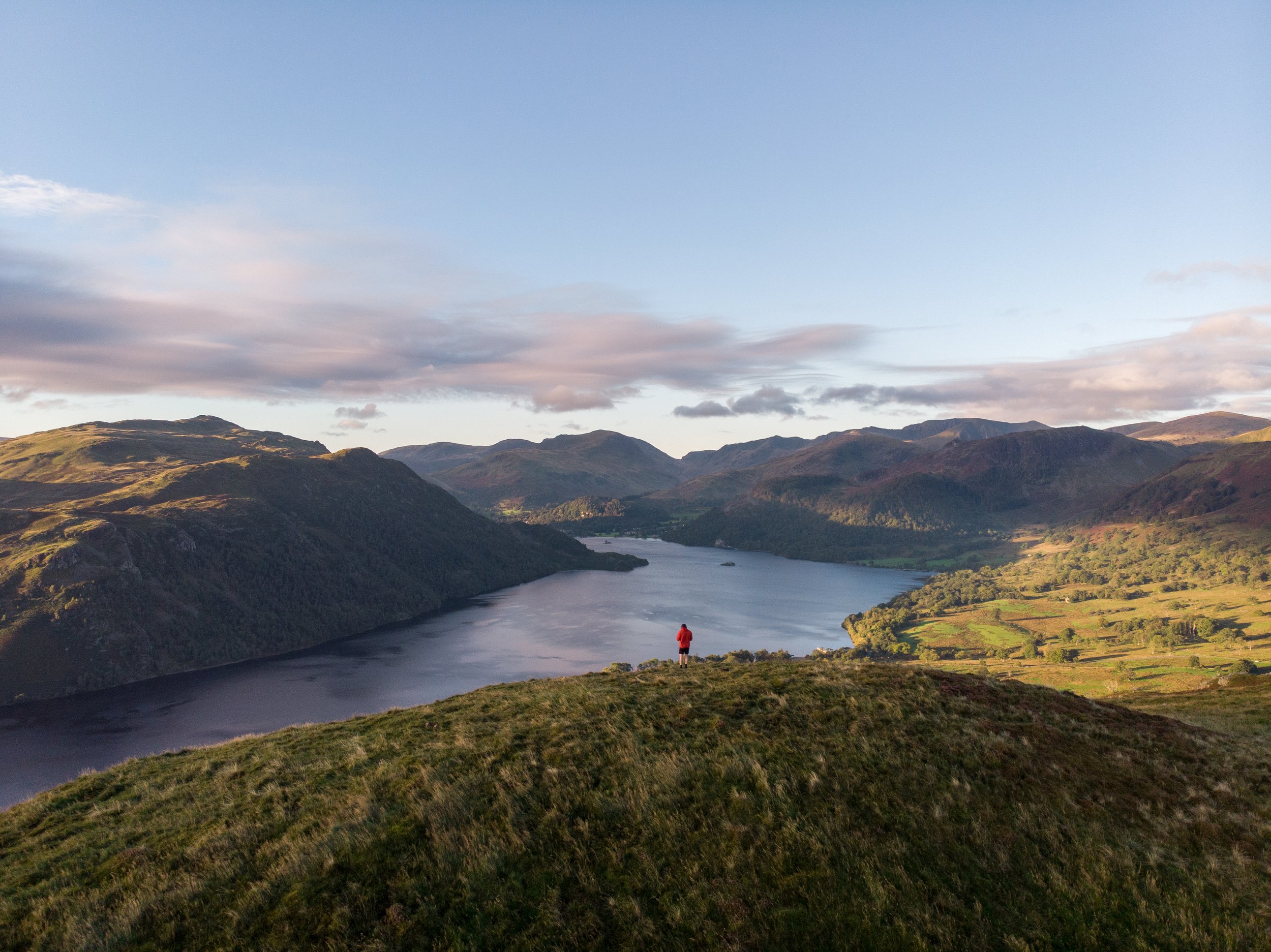
Glenridding Dodd, Ullswater
Hike type: Loop
Hike distance: 5.5km
Elevation gain: 385m
Hike time: 2-3 hours
This peak gives you unprecedented and unobstructed views over the entirety of Ullswater and is a great spot for sunrise
The route starts on the shores of Ullswater from the delightful Glencoyne Bay.
Avoid the mad crowds which can swarm on Glenridding during the summer months, The national trust car park is across the road from a tranquil shoreline which is perfect for a post hike wild swim.
If you have a little more in the legs you can extend this walk by continuing up to Heron Pike and then Sheffield Pike, this will add an extra 2km and 270m of elevation gain.


Raven Crag, Thirlmere
Hike Type: Out (up) and back
Hike distance: 3.2km
Elevation gain: 262m
Hike time: 1.5-2 hours
Parking: Roadside next to High bridge End caravan site
Short but savagely steep, if your in a rush and want epic views then Raven Crag is a sure bet.
The summit affords you a terrific view looking south over Thirlmere and is a great choice for both sunrise or sunset.
The route climbs sharply through the forest from the outset, it levels out briefly for around 100m before kicking again for a short push to the summit.
As the road which leads to the base of the trail is closed due to a landslide, the best place to park is before the temporary barrier just past High bridge End caravan site on Dam Road.


Angle Tarn Pikes, Patterdale
Hike type: Out and back
Hike distance: 8km
Elevation gain: 471m
Hike time: 3 hours
Parking: White Lion Inn, Patterdale
Described by Alfred Wainwright as 'the best of Lakeland tarns', Angle Tarn is an enchanting glacial lake set high above the village of Patterdale.
The tarn is situated at an altitude of 500m, contains two rocky islands, and is enveloped by the Lake Districts majestical mountainous terrain.
The best views of angle tarn come from the 567m high Angle tarn pikes which sits above its northern shoreline.
Parking is available in front of the Patterdale Hotel (£4 for 24 hours) and from here it’s a 4km hike up to the tarn.


Catbells, Derwentwater
Hike type: Out and back
Hike distance: 4km
Elevation gain: 364m
Hike time: 2 hours
Parking: Limited roadside parking - ///sonic.lifestyle.storyline
One of the most popular hikes in the Lake District for good reason.
Situated just outside of Keswick the views from the summit of Catbells over Derwentwater and towards Skiddaw and Blencathra are sensational.
The undulating peak is easy to access and not that difficult to climb, especially when there are several flat sections which allow you to catch your breath and take in the scenery.
As there is limited free roadside parking at the base, I would get here early or late to avoid the crowds. The peak is a great choice for sunrise or sunset.
Catbells is also part of the Newlands Horseshoe, which is one of the very hard hikes on this list.


Green Hill, Gowbarrow Fell, and Aria Force
Hike type: Loop
Hike distance: 5.6km
Elevation gain: 363m
Hike time: 2-3 hours
Parking: Park Brow Car Park or Aira Force Car Park
Another peak on the shores of Ullswater which offers incredible mountain vistas.
Green hill only sits at an elevation of 443m but it certainly packs a punch, offering terrific views over Ullswater alongside some incredible mountain vistas.
Although you don’t get a full view of Ullswater like that from Glenridding Dodd, you are treated to a great view looking east towards Pooley Bridge and south west towards the Helvellyn Range.
There is no trig point for this peak and the terrain of the hill is very undulating and lumpy meaning it can be hard to find. The good news is there are plenty of spots on the hill which offer great views over the lake.
This loop which also ties in a visit to Gowbarrow fell is incredibly varied, calling by both Aria and High Force, which are two of the most popular waterfalls in the Lake District.
I would tackle this walk early, and in an anti clockwise fashion, visiting Aria Force first before heading up Green Hill and a round to Gowbarrow fell

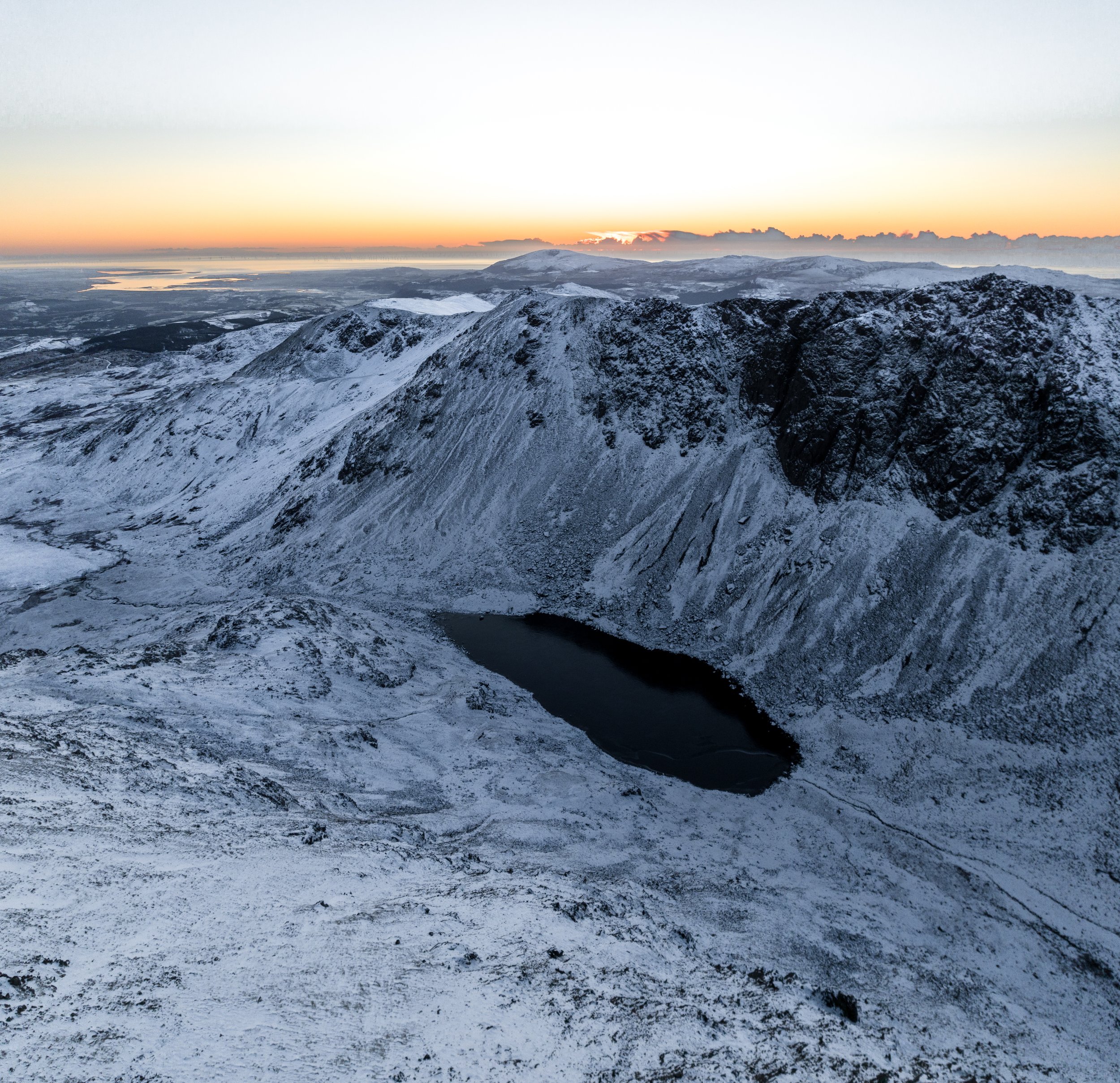
Black Combe, Broughton in Furness
Hike type: Out and back
Hike distance: 7km
Elevation gain: 560m
Hike time: 2.5-4 hours
Parking: St Mary's Church
Situated on the coast in south-west corner of the Lake District, this 600m peak is a bit of an undervisited and under appreciated gem of the National Park.
Because Black Combe stands in some 10 miles away from any other high ground, On a clear day its isolated summit offers a terrific 360 degree panoramic view of land and sea. The Isle of Man can be seen clearly to the west, and the hills of Wales and Scotland seen as shadowy silhouettes to the north and south.
Free parking is available at St Marys church and its a steady 3.5km plod up to the summit.

On the way up to Black Combe
Hard Walks
These walks would be characterised by being relatively long and involve a significant amount of elevation gain.
They will also navigate some sections of steep and possibly technical terrain which may require elements of scrambling, The hikes will usually take several hours to complete so the appropriate gear is needed alongside plenty of food and water.
Apart from Blencathra all of these hikes are dog friendly providing you keep them on a lead at all times.
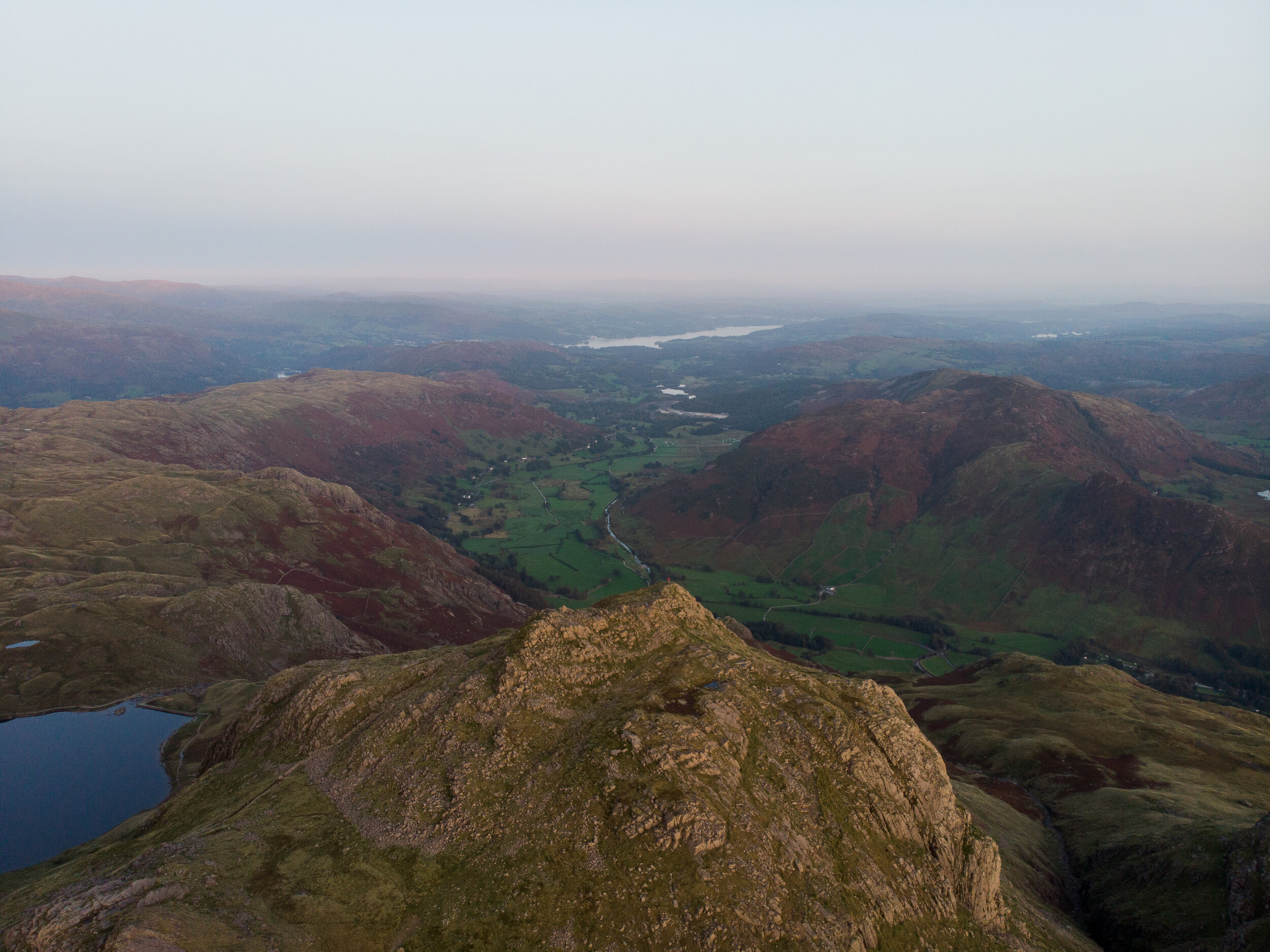
Stickle Tarn and the Langdale Pikes
Hike type: Loop
Hike distance: 9km
Elevation gain: 960m
Hike time: 3-5 hours
Wainwrights summited: Pavey Ark, Thuncar Knott, Pike O Stickle, Loft Crag, Harrison Stickle
Stickle Tarn is another tranquil mountain lake situated in the Langdale valley.
At an elevation of 500m, the tarn sits in a wide mountainous bowl beneath the peaks of Pavey Ark and Harrison Stickle and offers glorious views back down the Langdale Valley towards Lake Windermere.
The route initially follows a well-built path on the east side of Stickle Ghyll for one mile up to Stickle Tarn.
The path is not technical but does get steep in places, gaining 370m in elevation in just under a mile. The trade-off is that there are half a dozen waterfalls on route which provide a great excuse to stop for a breather.
From Stickle Tarn you continue to hike up to Pavey Ark, Thuncar Knott, Pike O Stickle, Loft Crag, and Harrison Stickle, where you will get magnificent panoramic views of the southern and western Fells.

Fleetwith Pike and Haystacks
Hike Type: Loop
Hike distance: 8km
Elevation gain: 768m
Hike time: 3-5 hours
Wainwrights summited: Fleetwith Pike (648m), Haystacks (597m)
Technical aspects: Minor scrambling on Haystacks
Parking: Gatesgarth Car Park
One of the classic walks in the Buttermere valley which summits Fleetwith Pike alongside Alfred Wainwright’s favourite hill – Haystacks.
The loop starts with punchy and steep climb up to Fleetwith Pike. From this summit you will be granted stupendous views back down the Buttermere valley and over the surrounding fells.
You'll then briefly descend past two of the Lake Districts bothies before climbing back up to rocky summit of Haystacks.
On the descent you have the option to extend your hike up to High Crag (745m). This will add an extra 2km and 250m of elevation gain to the route.

The view from half way up Fleetwith Pike

The view of Fleetwith Pike and Haystacks from Buttermere
Blencathra via Sharp Edge
Hike type: Loop
Hike distance: 7km
Elevation gain: 659m
Hike time: 2.5-5 hours
Wainwrights summited: Blencathra (868m)
Technical aspects: Exposed grade 1 scrambling
Parking: Limited parking at Comb Beck ///motoring.terminology.dumps
Blencathra, also known as Saddleback, is an iconic part of the Lake District landscape. Its distinctive table-top shape which towers above the town of Keswick makes it instantly recognisable.
The ascent via the notorious Sharp Edge, one of the Lake District’s most famous Grade 1 scrambles, is a shot but thrilling route which is best saved for a fine day.
People have died falling from this knife edge ridge so treat it with respect and only tackle it if you are confident with heights, have the appropriate footwear and in the right conditions.
Blencathras location and short distance to the summit also makes this a great mountain to ascend for sunrise.


Sharp Edge

Blencathra from Catbells
Old Man of Coniston via Dow Crag
Hike Type: Loop
Hike distance: 10km
Elevation gain: 740m
Hike time: 4-6 hours
Wainwrights summited: Dow Crag (778m) Old Man of Coniston (803m)
Technical aspects: Some minor scrambling
Parking: Walna Scar Car Park - W3W:quote.guides.dent
The highest point of the historic county of Lancashire, the Old Man of Coniston is iconic peak in the eastern Lake district.
The 803m peak towers over the small town of Coniston and Coniston Water and offers extensive views over the southern Lake District, Morecambe Bay, the Pennines, the Lancashire coast, and the Isle of Man.
Best tackled clockwise, this aried and slightly technical route which has a bit of everything -magnificent views, two great mountains, a trip through and old slate mine, and several hidden tarns.
Dow Crag is a lot quieter than the Old Man, however reaching it does involve a little bit of scrambling.
If you dont fancy the technical element, I would recommended skipping out Dow Crag and ascending up to the Old Man via Goats Water instead.
Goats water beneath Dow Crag

The summit of the Old Man above Low Water
Great Gable from Honister Pass
Hike type: Out and back
Hike distance: 9km
Elevation gain: 739m
Hike time: 4-6 hours
Wainwrights summited: Great Gable (899m), Green Gable (801m), Brandreth (715m), Grey Knotts (694m)
Technical aspects: Minor, non exposed scrambling
Parking: Honister Pass - £5 all day
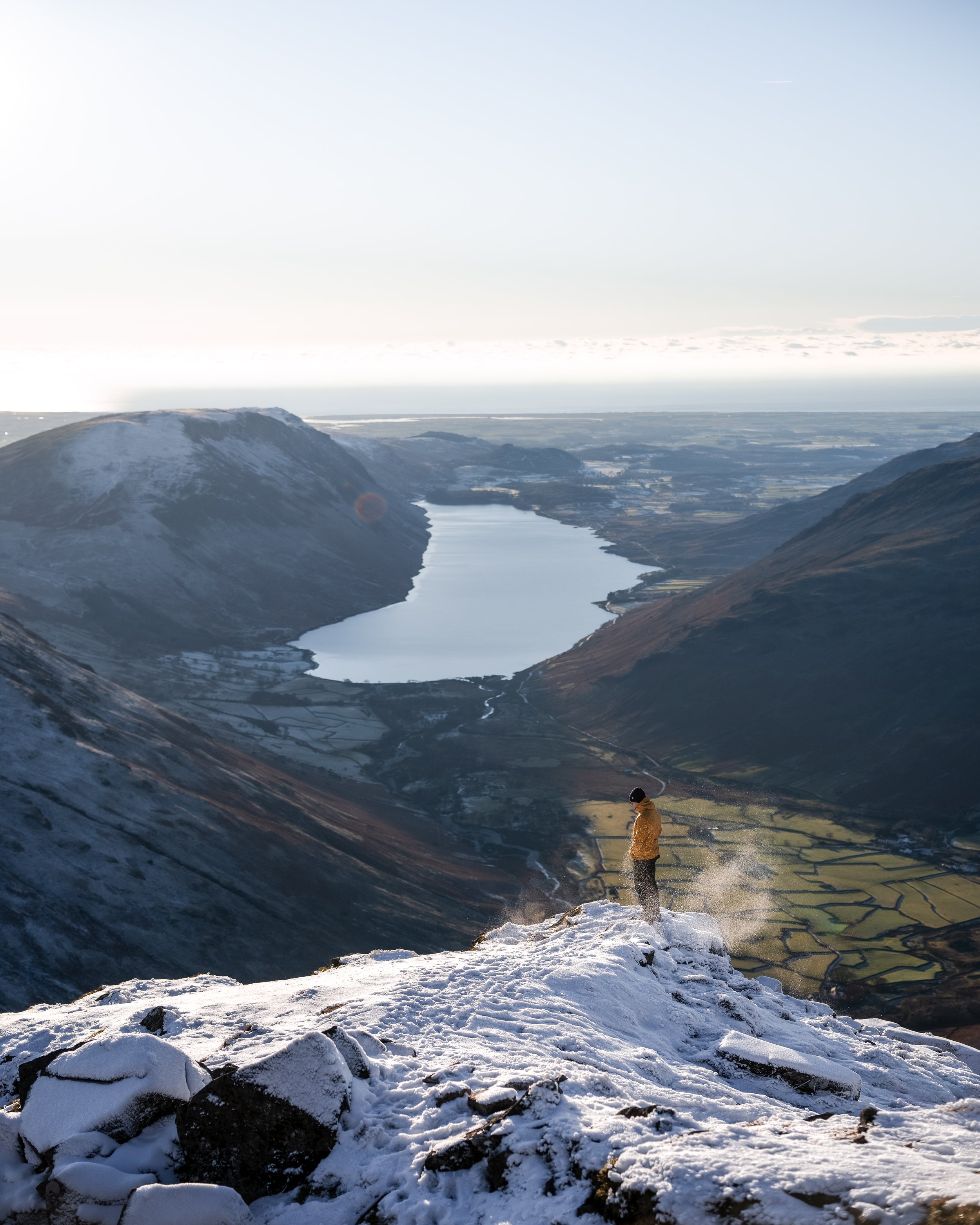
A splendid walk to one of the finest view points in the Lake District.
The summit of Great Gable may not be the highest, but its unobstructed views down the Wastwater valley over the Lake Districts deepest lake are unprecedented.
The route starts at the Honister pass which cost £5 for all day parking.
I'd advise skirting around the wainwrights of Bandreth and Grey Knotts on the ascent and bag them on the way back down. This way you’ll ease yourself into the hike and avoid starting with very steep initial ascent.
Although not technical or exposed, the final climb up to Great Gable is very steep and may require some minor scrambling.

Skiddaw via Longside Edge
Hike type: Loop
Hike distance: 10km
Elevation gain: 925m
Hike time: 4-6 hours
Wainwrights summited: Ullock Pike (691m), Long side (734m), Carl Side (746m), Skiddaw (931m)
Parking: W3W: additives.boil.vines
A cracker of a route in the northern fells which calls by three wainwrights before summiting the monolith which is Skiddaw.
The anticlockwise route (do not tackle this clockwise) takes in some wide and non exposed ridge walking and offers sensational views south over Derwentwater and north back up towards Scotland.
There are some steep sections on the route, especially on the final climb and the descent down from Skiddaw, however it’s nothing technical and the views certainly make up for this.
Parking is in a layby off a narrow road and is very limited, with space for 6 cars, so get there early to snag a space.

Helm Crag and Wythburn Fells
Hike type: Loop
Hike distance: 10km
Elevation gain: 687m
Hike time: 3-5 hours
Wainwrights summited: Steel Fell, Helm Crag, Gibson Knott, and Calf Crag
Parking: Little Town - ///flamed.moon.hikes
A stones throw from the popular village of Ambleside, this 10km loop is one of the Lake District's finest rounds of the less prominent fells.
Of the wainwrights visited, Helm Crag is the most well known due to its unique and prominent rocky summit which offers terrific views over Grasmere and surrounding fells.
Although Helm Crag is worthy of a visit in itself, a full circuit of Steel Fell, Gibson Knott, and Calf Crag is a terrific loop and is needed to get a full appreciation of this incredible area.


Fairfield Horseshoe
Hike type: Loop
Hike distance: 15km
Elevation gain: 1,088m
Hike time: 5-8 hours
Wainwrights summited: Dove Crag, Fairfield, Great Rigg, Hart Crag, Heron Pike, High Pike, Low Pike, Nab Scar
Technical aspects: Some minor scrambling
Parking: Pelter Bridge Car Park, Rydal


This route is a cracking day out in the fells and is definitely a must do hike if you’re staying in the surrounding area.
A combination wide ridges, sweeping scenery, panoramic vistas, and no-less than eight Wainwrights makes this horseshoe one of the best in all of Lakeland.
Although long, the hike isn’t technical and only has one very steep initial climb.
The route I have plotted is a shorter version of the classic which usually starts in Ambleside. I've also modified the route so it calls by Buckstones jump on the way back down.
This is a delightful series of plunge pools situated at the base of the valley which are perfect for a post hike dip so dont forget to pack a towel.
Very Hard Hikes
Characterised by being long days in the hills, these hikes involve over 1,000m of elevation gain, lots of steep climbs, and some technical aspects.
A good level of fitness is needed to tackle these alongside the correct and appropriate hiking gear, knowledge of navigation, and plenty of food and drink.
Kentmere Horseshoe
Hike Type: Loop
Hike distance: 20km
Elevation gain: 1,182m
Hike time: 5-8 hours
Wainwrights summited: High Street, Thornthwaite Crag, Harter Fell , Mardale Ill Bell, Ill Bell, Kentmere Pike, Froswick, Yoke, Shipman Knotts
Parking: Kentmere Institute
One of the longest and most remote walks in the Lake District, the Kentmere Horseshoe is a mega day out in the mountains.
The route traverses all the fells which surround the upper Kentmere valley and its reservoir, summiting nine wainwrights in total.
The route will give you great views back south towards Windermere and looking north towards the Helvellyn range.
I’d recommend tackling this hike if you want to escape the crowds alongside ticking off as many Wainwrights as possible in one walk.
Limited parking is available beside the village hall in the hamlet of Kentmere so get there early to make sure you’ve got a space.


Newlands Horseshoe
Hike Type: Loop
Hike distance: 15km
Elevation gain: 1031m
Hike time: 5-7 hours
Wainwrights summited: Hindscarth, Dale Head, Maiden Moor, High Spy, Catcalls
Parking: Little Town - W3W: receive.professed.craziest
Only a stones throw from Keswick, the Newlands Valley nestles within the fells on the western side of Derwentwater and encompasses an amazing array of mountain scenery.
This walk tackles the skyline crest above the valley and calls by 5 wainwrights in the process. Aside from some steep climbs and elements of scree the route isn’t technical and is relatively easy to follow
Its a cracking day out and offers terrific views back down the valley towards Skiddaw, especially from the highest point on the walk, Dale Head.


Great Langdale Round
Hike Type: Loop
Hike distance: 19km
Elevation gain: 1,694
Hike time: 6-10 hours
Technical aspects: Lots of scrambling
Wainwrights summited: Pike O'Blisco (701m), Crinkle Crags (859m), Bowfell (902m), Pike O'Stickle (709m), Harrison Stickle (720m)
Parking: National Trust - Sticklebarn
A monster hike which traverses the Mickleden valley in Great Langdale, visiting the summits of 6 mountains on the way.
Now I cant comment on how hard this loop is as I’ve never completed it in one go. I have hiked the two halves separately and can tell you they are both cracking routes with epic views, so if you combine them both you’re in for one long but epic day out in the hills
This route starts off climbing Pike of Blisco before heading around and over Crinkle Crags before ascent of the highest peak on the hike– Bow Fell. You’ll then tackle the Langdale Pikes before descending past stickle tarn and back down into the Langdale valley.


Coledale Round
Hike Type: Loop
Hike distance: 15.4km
Elevation gain: 1,302
Hike time: 5-8 hours
Wainwrights summited: Grisdale pike (791m), Hopegill head (770m), Crag hill (838m), Sail (773m), Scar crags (672m), Causey pike
Technical aspects: one steep bastard slope which require some minor scrambling
Parking: Car Park off Winlatter Pass
A proper day out in the mountains, this horseshoe takes in the entire skyline of the Lake District’s Coledale valley, visiting 6 Wainwrights in the process.
The route is incredibly varied with a mixed bag of steep ascents, scrambles, rocky steps, and pleasant soft underfoot grassy lawns.
It is probably my favourite of the all the Lake District horseshoes, mainly because of the incredible ever changing views throughout the hike.
The only negative would be the savagely steep initial climb up to Grisdale Pike. Once you’ve gotten that out of thee way everything else will seem like a breeze.

Helvellyn via the edges
Hike Type: Loop
Hike distance: 13km
Elevation gain: 924m
Hike time: 4-6 hours
Technical aspects: Two exposed ridges which will require scrambling
Wainwrights summited: Helvellyn (950m) Catstye Cam (890m)
Parking: Glenridding
For those who like adventure, there's only one way to climb Helvellyn and that's from Glenridding using Striding and Swirral Edges to form a horseshoe.
This classic route, which tackles two of the Lake districts most iconic ridges, isn't for the faint-hearted and experience of scrambling is required.
The views are exceptional and the full panorama which you are granted from the third-highest point in England is phenomenal.
If you are tackling this hike in peak season or on a weekend I would recommend an early start, otherwise you may encounter a traffic jam on the ridge and the specialness of the hike will be reduced.
Also make sure you pop into Helvellyn café for a hearty bite to eat and a coffee post hike.


Scafell Pike from Seathwaite
Hike Type: Loop
Hike distance: 15.6 km
Elevation gain: 1,143m
Hike time: 5-8 hours
Technical aspects: Some minor scrambling up loose scree
Wainwrights summited: Lingmell (807m), Scafell Pike (978m), Great End (910m)
Parking: Seathwaite Farm
The ascent of Scafell Pike via the corridor route is a classic Lakeland round which provides superb high level hiking on the way up to England’s highest peak.
This is a tough outing covering many miles of stony and difficult terrain where great care is needed. However, this walk has a real mountaineering flavour to it and includes some easy scrambling.
You also have the option to bag two more wainwrights by calling by the lofty viewpoints of Lingmell and Great End.


Mosedale Horseshoe
Hike Type: Loop
Hike distance: 16km
Elevation gain: 1,514m
Hike time: 6-9 hours
Technical aspects: Some scrambling, lots of steep climbs
Wainwrights summited: Kirk Fell, Pillar, Scoat Fell, Red Pike, and Yewbarrow
Parking: Wasdale Head Car Park
A monster of a walk which is one of the finest and difficult mountain days in the Lake District.
The route starts at the isolated Wasdale head, with the drive to the car park requiring nearly a much effort as the hike itself. However the views over the deepest lake in the Lake District are worth the trip in itself.
The hike takes in 8 summits, 5 of which are Wainwrights, with the most iconic of those being the summit of Pillar.
At 892 metres (2,927 feet) it is the eighth-highest mountain in the Lake District. The fell takes its name from Pillar Rock, a prominent feature on the Ennerdale side, regarded as the birthplace of rock climbing in the district.
Alongside being granted incredible views, the difficulty of the hike and its isolated location means you wont encounter very many people on this walk.

Mosedale horseshoe as viewed from Great Gable

Wastwater
Help support my website
So there we have it, my favourite 35 hikes in the Lake District. If I had to pick a favourite it would be Helvellyn closely followed by the Newlands Horseshoe and Coledale round. My choice of the low level walks would be a loop of Buttermere and for easy views Latrigg Fell.
How many of these hikes have you done and which is your favourite? Let me know your thoughts in the comments below
I created and run this website in order to help inform, amaze, inspire people (for free) to get outside and explore the adventurous side of the UK.
Although I do run some google ads, I have limited them in order to make your experience on this website far more enjoyable.
If you’d like to support this website, you can use the affiliate links below to book your accommodation or transport. These come at no extra cost to you, but help keep this site running.
Book your vehicle using Discover Cars
Book your accommodation using Booking.com
If you are feeling generous you can also Buy me a Coffee to say thank you, and give me a follow on social media.
Thank you, and if you have any questions, leave them in the comments below or drop me an email.
You can find more Lake District inspiration in the following blogs;
The best viewpoints in the Lake District - 12 easy to access locations
The hardest hikes in the Lake District National Park - 14 challenging routes
35 of the best hikes in the Lake district - From beginner to advanced
3 must visit Quarries and Caves in the Lake District
You can find more hiking inspiration in the following blogs

Find me on Instagram


